Download
1 / 12
140 likes | 402 Vues
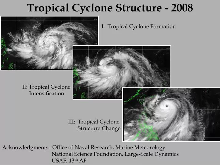
Tropical Cyclone Structure - 2008. I: Tropical Cyclone Formation. II: Tropical Cyclone Intensification. III: Tropical Cyclone Structure Change. Acknowledgments: Office of Naval Research, Marine Meteorology National Science Foundation, Large-Scale Dynamics

E N D
Tropical Cyclone Structure - 2008 I: Tropical Cyclone Formation II: Tropical Cyclone Intensification III: Tropical Cyclone Structure Change Acknowledgments: Office of Naval Research, Marine Meteorology National Science Foundation, Large-Scale Dynamics USAF, 13th AF
Key science questions to be addressed in a program aimed at increased understanding and predictability of tropical cyclone characteristics during formation, intensification, and recurvature over the western North Pacific • Highlights • Incorporates multiple space and time scales • Large scale controls • Global and basin-wide spatial scales • Medium-range and synoptic temporal scales • Mesoscale organization pathways • During formation • During intensification • Primary hypotheses with respect to: • Large-scale role in pre-conditioning • Mesoscale organizational pathways leading to construction of a potential vorticity monolith • Role of low-level convergence associated with deep convective cells • Stratiform regions of mesoscale convective systems • Relative roles of environmental and vortex structures in determining the evolution of the outer wind structure • In tandem with the THORPEX Pacific Asian Regional Campaign (T-PARC)
Tropical cyclone formation, structure and structure change:Challenges to Maritime Operations • Variety of conditions from which a tropical cyclone may form over the western North Pacific Pre-TY Tokage monsoon depression TY Tokage 0000 UTC 14 October 2004 Warning graphics from the Joint Typhoon Warning Center for TY Tokage. The shaded region defines the danger area to be avoided. This area is based on the uncertainty associated with track and outer wind structure over the ensuing five days. Note: The danger area nearly covers the entire East China Sea for a period of at least 5 days. The change in track forecast from straight to recurvature, which may be due to the influence of the outer wind structure TY Tokage: 0000 UTC 14 October 2004 TY Tokage: 1200 UTC 15 October 2004
What are the relative roles of the primary mesoscale mechanisms (bottom-up and top-down) in determining the location, timing, and rate of tropical cyclone formation in the monsoon trough environment of the tropical western North Pacific? http://www.nrlmry.navy.mil/sat_products.html http://www.nrlmry.navy.mil/sat_products.html 10o 19o Pre-Fitow (10W 2007) disturbance Pre-Man-Yi (04W 2007) disturbance Objective: Increased predictability associated with the location, timing, and rate of tropical cyclone formation over the western North Pacific
What are the relative roles of environmentally-induced and vortex-generated mechanisms versus cyclogenesis-determined initial conditions in determining the outer wind structural evolution of western North Pacific tropical cyclones? Synoptic Type: Large Tropical Cyclones Combination type Large and Small Tropical Cyclones Synoptic Forcing Mesoscale type: Small Tropical Cyclones Mesoscale Forcing Objective: Increased understanding and predictability of factors that impact the evolution of the outer-wind structure of an intensifying tropical cyclone over the western North Pacific.
NW NOAA 43 1430-1520Z 10,000’ North TMI 85H 9-22-05 1443Z Satellite – Aircraft Comparisons Hurricane Rita Graphic supplied by J. Hawkins
VALIDATION OF SATELLITE ALGORITHMS WESTERN NORTH PACIFIC TROPICAL CYCLONE STRUCTURE AND STRUCTURE CHANGE INCLUDING INTENSITY CHANGE AF C-130 STEPPED FREQUENCY MICROWAVE RADIOMETER (SFMR) AND DROPWINDSONDES AT ALL STAGES FROM FORMATION TO EXTRATROPICAL TRANSITION IN COOPERATION WITH T-PARC DOPPLER WIND LIDAR ON NRL P-3 VERTICAL PROFILES OF WIND VECTORS TO THE SURFACE (CROSS-CALIBRATION WITH C-130 SFMR) IN CLOUD-FREE SCENES – FIRST TIME IN TROPICAL CYCLONE COHERENT WIND STRUCTURES IN BOUNDARY LAYER OVER OCEAN IN TROPICAL CYCLONES (Emmitt and Foster)
Observing Platforms (1 August – 30 September) • NRL P-3/ NCAR ELDORA/ DWL lidar/ GPS Dropwindsondes • 50/50 funding split between NSF and ONR • Operation from Andersen AFB, Guam, Kadena AFB, Okinawa, Atsugi NAF, Misawa NAF Japan • Total of 150 research hours • 450 dropwindsondes (30 sondes per mission) • USAF Reserve 53rd Weather Squadron (Hurricane Hunter) WC-130J • Funding from ONR and USAF • Operation from Andersen AFB, Guam, Kadena AFB, Okinawa, Yokota AFB, Japan • Dropwindsondes • Stepped Frequency Microwave Radiometer • AXBTs, Drifting Buoys • Other Components • DOTSTAR • Driftsondes • Launch from Hawaii • 20 balloons with dropwindsonde gondolas • 40 dropwindsondes per gondola • Satellite: MTSAT rapid scan, Polar orbiting platforms
Pre- TY 10W (Fitow) Disturbance Combined missions during tropical cyclone formation Use of Eldora to measure characteristics associated with deep convection Use of WC-130 to measure the environmental characteristics
Pre-Pabuk Tropical Wave PGUM Lawnmower Pattern
Tropical Storm WC-130J Survey: BUTTERFLY PA~300-700 mb, IAS~280-240 kt (280 kt transit) Leg radii~110 nm 9.5 hr duration 1.5 hr creep/day GPS Dropsonde: 7 sondes per leg +3 = 24 total (eyewall multi-sonde ~5 per leg = +15; 39 total) AXBTs: 7 AXBTs per leg +2 diagonals x4 = 29 total 1944 UTC 10 July 2007 TMI 85 GhZ H Targeting Option Track PGUM Butterfly Pattern Man Yi
Summary • Much recent national and international attention on TCs • Four Major Weather Forecast Problems in the Pacific • Lack of understanding of storm scale processes is the biggest knowledge gap (basic research common to all four) • Proposing: • First major WESTPAC field experiment since TCM93 • First detailed observations of TC outer winds, genesis & life-cycle (in situ aircraft, radar, dropsondes, lidar, remote sensing) • First measurements. to validate new and advanced satellite obs. of WP TCs • Utilize the post-CBLAST coupled ocean-wave-atmosphere modeling system as a testbed to gain understanding of the processes as informed and constrained by the field data • Expected accomplishments: • Increase the predictability of the environmental forcing, formation, outer wind structure and intensity of TCs over the western North Pacific • Leverage several international efforts • GOAL: to reduce errors in TC structure and intensity forecasts by 50% within a decade • will also increase warning times and improve ocean and wave forecasts