Download
1 / 36
360 likes | 510 Vues
Ch 20: Weather Patterns and Severe Storms. Overview TAKE NOTES ON bullet points!!. Air Masses and Weather. Air Mass – immense body of air that is characterized by similar temperatures and amounts of moisture at any given altitude

E N D
Ch 20: Weather Patterns and Severe Storms Overview TAKE NOTES ON bullet points!!
Air Masses and Weather • Air Mass – immense body of air that is characterized by similar temperatures and amounts of moisture at any given altitude • Because of its size, it may take several days for an air mass to move over an area (giving that area fairly constant weather) • When an air mass moves out of the region over which it formed, it carries its temperature and moisture conditions with it • As it moves, the characteristics of an air mass change, and so does the weather in the area over which the air mass moves
Classifying Air Masses • The area over which an air mass gets its characteristic properties of temperature and moisture is called its source region • Air masses are named according to their source region • Polar (P) air masses (cold air) form at high latitudes, while tropical (T) air masses (warm air) form at low latitudes • In addition to their overall temperature, air masses are classified according to the surface over which they form • Continental (c) form over land (dry air) and maritime (m) form over water (humid air) • The four basic types of air masses in North America: Continental Polar (cP) – cold and dry Continental Tropical (cT) – warm and dry Maritime Polar (mP) – cold and moist Maritime Tropical (mT) – warm and moist
Weather in North America • Much of the weather in North America, especially weather east of the Rocky Mountains, is influenced by continental polar (cP) and maritime tropical (mT) air masses • Continental polar air masses are uniformly cold and dry in winter and cool and dry in summer; lake-effect snow is caused when one of these air masses passes over the moisture of the lake and drops the precipitation down on the leeward side of the lake • Maritime tropical air masses are warm, loaded with moisture, and usually unstable; they are the source of much of the precipitation in the eastern two thirds of the U.S. • During the winter, maritime polar (mP) masses that affect weather in North America come from the North Pacific • Continental tropical air masses have the least influence on the weather of North America • Only occasionally do continental tropical (cT) air masses affect the weather outside their source region
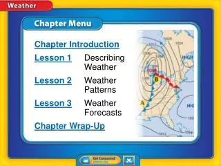
Formation of Fronts • When two air masses meet, they form a front, which is a boundary that separates two air masses • Fronts can form between any two contrasting air masses • In contrast to the vast sizes of air masses, fronts are narrow (~15-200 km wide) • In the ideal case, the front would move in the same direction with warmer air overlying cooler air • However, the distribution of pressure across a front causes one air mass to move faster than the other, causing it to advance into the slow air mass
Warm Fronts • A warm front forms when warm air moves into an area formerly covered by cooler air • The surface position of a warm front is shown by a red line with semi-circles that point toward the cooler air • The first sign of the approaching warm front is the appearance of cirrus clouds • Because of their slow rate of movement and very low slope, warm fronts usually produce light-to-moderate precipitation over a large area for an extended period • A gradual increase in temperature occurs with the passage of a warm front, as does a wind shift from the east to the southeast
Cold Fronts • A cold front forms when cold, dense air moves into a region occupied by warmer air • On a weather map, the surface position of a cold front is shown by a blue line edged with blue triangles that point toward the warmer air mass • As a cold front moves in, it becomes steeper and advance more rapidly than warm fronts • The forceful lifting of air along a cold front can lead to heavy downpours and gusty winds • As a cold front approaches, towering clouds can often be seen in the distance • The weather behind a cold front is dominated by a cold air mass, so weather clears shortly after the front has passed
Stationary Fronts • Occasionally, the flow of air on either side of a front is neither toward the cold air mass nor toward the warm air mass, but almost parallel to the line of the front • The surface position of the front does not move, and a stationary front forms • On a weather map, stationary fronts are shown by blue triangles on one side of the front and red semicircles on the other • Sometimes, gentle to moderate precipitation occurs along a stationary front
Occluded Fronts • When an active cold front overtakes a warm front, an occluded front forms • The weather associated with an occluded front is complex: most precipitation is associated with the warm air’s being forced upward • Remember, fronts, like all aspects of nature, do not always behave as we expect them to
Middle-Latitude Cyclones • The main weather producers in the U.S. are middle-latitude cyclones, denoted by the letter L • Middle-Latitude Cyclones – large centers of low pressure that generally travel from west to east and cause stormy weather • The air in these weather systems moves in a counterclockwise direction and in toward the center of the low • Most middle-latitude cyclones have a cold front, and frequently a warm front, extending from the central area • Forceful lifting causes the formation of clouds that drop abundant precipitation
The Role of Airflow Aloft • Airflow aloft plays an important role in maintaining cyclonic and anticyclonic circulation • The rotating wind systems are actually generated by upper-level flow • Surface convergence must be offset by outflow somewhere higher in the atmosphere • As long as the spreading out of air high up is equal to or greater than the surface inflow, the low-pressure system can be sustained • More often than not, air high up in the atmosphere fuels a middle-latitude cyclone • In an anticyclone, air spreading out at the surface is balanced by air coming together from high up
Thunderstorms • Thunderstorm – a storm that generates lightning and thunder; frequently produce gusty winds, heavy rain, and hail • Thunderstorms may be produced by a single cumulonimbus cloud, or it may be associated with clusters of cumulonimbus clouds along a cold front • At any given time, there are an estimated 2000 thunderstorms in progress on Earth (~45,000 a day and 16 million a year); the U.S. experiences ~100,000 a year • Thunderstorms form when warm, humid air rises in an unstable environment • The life span of a single cumulonimbus cell within a thunderstorm is only about an hour or two, but as the storm moves, it is constantly getting fresh supplies of warm, humid air
Tornadoes • Tornadoes – violent windstorms that take the form of a rotating column of air called a vortex; the vortex extends downward from a cumulonimbus cloud • In the U.S., ~770 tornadoes are reported each year; greatest occurrence between April and June • Most tornadoes form in association with severe thunderstorms • An important process in the formation of many tornadoes is the development of a mesocyclone (see diagram) • Pressures within some tornadoes can be as much as 10% lower than the surrounding area, causing air near the ground to be “sucked” into the vortex • One scale used to measure tornado intensity is the Fujita tornado intensity scale
Hurricanes (2) • Hurricanes – whirling tropical cyclones that produce winds of at least 119 kilometers per hour (also known as typhoons, cyclones, and tropical cyclones) • At sea, they can generate 15-meter high waves capable of destruction hundreds of kilometers away • A hurricane is a heat engine that is fueled by the energy given off when huge quantities of water vapor condense • Hurricanes develop most often in the late summer when water temperatures are warm enough to provide the necessary heat and moisture to the air
Eye Wall – doughnut-shaped wall that surrounds the center of the storm, where the greatest wind speeds and heaviest rainfall occur • Eye – center of the storm where precipitation ceases and winds subside • The intensity of a hurricane is described using the Saffir-Simpson scale • Storm Surge – a dome of water about 65 to 80 km wide that sweeps across the coast where a hurricane’s eye moves onto land • A hurricane weakens when it moves over cooler ocean water and land
Assignment • Read Chapter 20 • Do Ch. 20 Assessment • #1-37 (pg. 583-584) • #1-4 (pg. 585) • Study for Chapter 20 Quiz!