Download
1 / 3
30 likes | 502 Vues
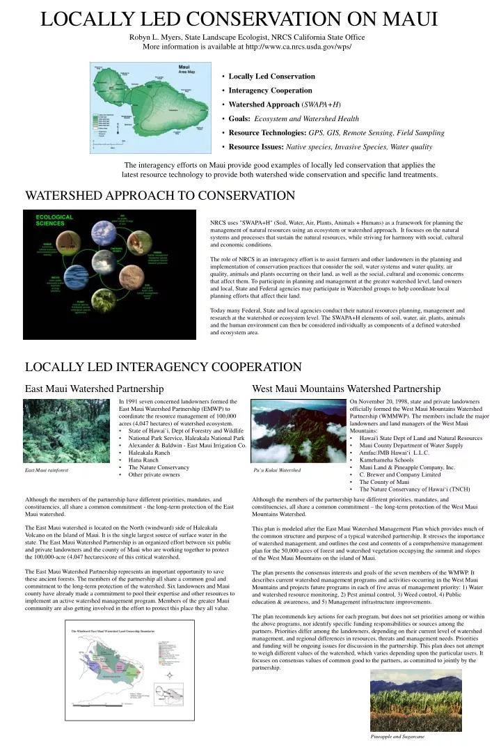
Locally Led Conservation Interagency Cooperation Watershed Approach ( SWAPA+H ) Goals: Ecosystem and Watershed Health Resource Technologies: GPS, GIS, Remote Sensing, Field Sampling Resource Issues: Native species, Invasive Species, Water quality. LOCALLY LED CONSERVATION ON MAUI.

E N D
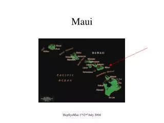
Locally Led Conservation • Interagency Cooperation • Watershed Approach (SWAPA+H) • Goals: Ecosystem and Watershed Health • Resource Technologies:GPS, GIS, Remote Sensing, Field Sampling • Resource Issues:Native species, Invasive Species, Water quality LOCALLY LED CONSERVATION ON MAUI Robyn L. Myers, State Landscape Ecologist, NRCS California State Office More information is available at http://www.ca.nrcs.usda.gov/wps/ The interagency efforts on Maui provide good examples of locally led conservation that applies the latest resource technology to provide both watershed wide conservation and specific land treatments. WATERSHED APPROACH TO CONSERVATION NRCS uses "SWAPA+H" (Soil, Water, Air, Plants, Animals + Humans) as a framework for planning the management of natural resources using an ecosystem or watershed approach. It focuses on the natural systems and processes that sustain the natural resources, while striving for harmony with social, cultural and economic conditions. The role of NRCS in an interagency effort is to assist farmers and other landowners in the planning and implementation of conservation practices that consider the soil, water systems and water quality, air quality, animals and plants occurring on their land, as well as the social, cultural and economic concerns that affect them. To participate in planning and management at the greater watershed level, land owners and local, State and Federal agencies may participate in Watershed groups to help coordinate local planning efforts that affect their land. Today many Federal, State and local agencies conduct their natural resources planning, management and research at the watershed or ecosystem level. The SWAPA+H elements of soil, water, air, plants, animals and the human environment can then be considered individually as components of a defined watershed and ecosystem area. LOCALLY LED INTERAGENCY COOPERATION East Maui Watershed Partnership West Maui Mountains Watershed Partnership • In 1991 seven concerned landowners formed the East Maui Watershed Partnership (EMWP) to coordinate the resource management of 100,000 acres (4,047 hectares) of watershed ecosystem. • State of Hawai`i, Dept of Forestry and Wildlife • National Park Service, Haleakala National Park • Alexander & Baldwin - East Maui Irrigation Co. • Haleakala Ranch • Hana Ranch • The Nature Conservancy • Other private owners • On November 20, 1998, state and private landowners officially formed the West Maui Mountains Watershed Partnership (WMMWP). The members include the major landowners and land managers of the West Maui Mountains: • Hawai'i State Dept of Land and Natural Resources • Maui County Department of Water Supply • Amfac/JMB Hawai‘i L.L.C. • Kamehameha Schools • Maui Land & Pineapple Company, Inc. • C. Brewer and Company Limited • The County of Maui • The Nature Conservancy of Hawai‘i (TNCH) East Maui rainforest Pu`u Kukui Watershed Although the members of the partnership have different priorities, mandates, and constituencies, all share a common commitment - the long-term protection of the East Maui watershed. The East Maui watershed is located on the North (windward) side of Haleakala Volcano on the Island of Maui. It is the single largest source of surface water in the state. The East Maui Watershed Partnership is an organized effort between six public and private landowners and the county of Maui who are working together to protect the 100,000-acre (4,047 hectares)core of this critical watershed. The East Maui Watershed Partnership represents an important opportunity to save these ancient forests. The members of the partnership all share a common goal and commitment to the long-term protection of the watershed. Six landowners and Maui county have already made a commitment to pool their expertise and other resources to implement an active watershed management program. Members of the greater Maui community are also getting involved in the effort to protect this place they all value. Although the members of the partnership have different priorities, mandates, and constituencies, all share a common commitment – the long-term protection of the West Maui Mountains Watershed. This plan is modeled after the East Maui Watershed Management Plan which provides much of the common structure and purpose of a typical watershed partnership. It stresses the importance of watershed management, and outlines the cost and contents of a comprehensive management plan for the 50,000 acres of forest and watershed vegetation occupying the summit and slopes of the West Maui Mountains on the island of Maui. The plan presents the consensus interests and goals of the seven members of the WMWP. It describes current watershed management programs and activities occurring in the West Maui Mountains and projects future programs in each of five areas of management priority: 1) Water and watershed resource monitoring, 2) Pest animal control, 3) Weed control, 4) Public education & awareness, and 5) Management infrastructure improvements. The plan recommends key actions for each program, but does not set priorities among or within the above programs, nor identify specific funding responsibilities or sources among the partners. Priorities differ among the landowners, depending on their current level of watershed management, and regional differences in resources, threats and management needs. Priorities and funding will be ongoing issues for discussion in the partnership. This plan does not attempt to weigh different values of the watershed, which varies depending upon the particular users. It focuses on consensus values of common good to the partners, as committed to jointly by the partnership. Pineapple and Sugarcane
USGS - Biological Research Division, Pacific Island Research Center has biological scientist and research and monitoring programs in Hawaii. They are coordinating much of the research, and the HEAR (Hawaiian Ecosystems at Risk) program with the University of Hawaii. Haleakala National Park is the home of the Haleakala Field Station of the USGS-BRD, and has NPS resource management staff conducting research and applying management techniques throughout the park and the greater East Maui Watershed. University of Hawaii -- The mission of the Hawaiian Ecosystems at Risk (HEAR) project is to provide technology, methods, and information to decision-makers, resource managers, and the general public to aid in the fight against harmful alien species in Hawaii. DLNR is responsible for the management of State-owned forests, natural areas, public hunting areas, and plant and wildlife sanctuaries. Program areas cover watershed protection; native resources protection, including unique ecosystems and endangered species of plants and wildlife. The Maui County NRCS office works with the local Soil and Water Conservation Districts and local lands owners. Through the Hawaii State Office, the California State Office and the Watershed Science Institute NRCS support technology development and transfer for locally led conservation efforts. Resource Conservation and Development (RC&D) provides a way for local residents to work together and plan how they can actively solve economic, environmental and social problems facing their areas. It pulls together communities, various units of government and grassroots organizations to help residents establish direction for their program. The Nature Conservancy of Hawai`i is the only non-profit organization devoted solely to the protection of Hawaii's native forests and wildlife. Using cooperation rather than confrontation, the Conservancy forges effective partnerships with business, government, individuals, and organizations that share a concern about the escalating rate of extinction worldwide. TNCH has protected 51,262 acres on six islands, 24,554 of which it currently manages either directly or cooperatively. The Hawai'i Natural Heritage Program (HINHP) is a non-profit affiliate of The Nature Conservancy of Hawai'i. HINHP compiles and maintains detailed, comprehensive information on Hawaii's rarest biological resources. The HINHP database is the state's largest computerized inventory of endangered, threatened, and rare plants, animals, and ecosystems, extracted from all available sources. It is a philosophy of Maui Land & Pineapple Co., Inc. that in order to be successful in the long term, we must balance our responsibilities equally -- to shareholders, employees, customers, and community; and in that regard, one of the company's objectives is to practice prudent stewardship of our land and water resources. As the parent company of East Maui Irrigation, C&H and Hawaiian Commercial Sugar company, A&B is both a private landowner, and a corporate funder of environmental programs. Conservation Partnerships on Maui Working together to preserve Hawai‘i’s Soil, Water, Air, Plants and Animals, and the Human Cultural and Economic Landscape in which we live. Photos from DLNR’s “A Glimpse of Paradise” The Partners and their Roles And other private land owners
Conservation Issue: Alien Species Invasion MISC - Maui Invasive Species Committee During its 2nd year, the Maui Invasive Species Committee Action Team (a partnership of government, private, and non-profit organizations) will continue actively eradicating and containing major incipient invasive plant species of Maui which threaten the State’s most intact federal, state, and private conservation lands and nearly 80 federally-listed endangered plant species. The unanimous support from state, county, federal and private agencies demonstrates that government, business and the public look toward MISC as the model that can eradicate newly established pests, prevent them from spreading and expanding to other islands, and ultimately preserve the State’s environment and economy. Over the years the program has grown, but it was originally sponsored under Tri-Isle RC and D, and has since evolved into a multi-agency effort. In the last few years, Invasive Species Committees have also been organized on the Big Island, Molokai and Kauai. Tri-Isle RC&D Eradication of Invasive Species - Success Story Miconia calvescens Eradication Project (from the National RC&D Net Web site) Miconia calvescens was introduced on Maui as an ornamental plant from Latin America. It has big beautiful leaves getting as large as three feet long with a purplish color on the underside. The tree grows to a height of 40 feet. It is very invasive, as it produces millions of seeds annually. As it grows, it replaces all other plant species because it grows so tall and has such large leaves. Sunlight can not penetrate to the forest floor. When the various plant species diminish, the animal species depending on the variety of plants also diminish. The result is a monoculture with an unprotected forest floor very susceptible to erosion. The Maui Invasive Species Committee was formed to eradicate Miconia calvescens and other invasive plants. The committee is made up of a group of agencies which is educating the public, removing existing plants, and evaluating the extent of the problem. The lead agency for this project is the Department of Land and Natural Resources, Division of Forestry and Wildlife. Participating agencies include Tri-Isle Resource Conservation and Development, the Nature Conservancy of Hawaii, Hawaii Department of Agriculture, Maui Community College, Maui County Office of Economic Development, University of Hawaii, Maui Land and Pineapple Company, Inc., Haleakala National Park, the United States Department of Agriculture and the USDI Geological Survey. Monitoring Strangers in Paradise: Using Remote Sensing and GIS to Monitor Miconia and Other Plant Species in the East Maui Watershed Under a grant from The Nature Conservancy Ecosystem Research Program, Principal Investigators Dr. Jonathan C. Gradie, TerraSystems, Inc., Honolulu, Hawaii, and Dr. Robyn L. Myers, Natural Resources Conservation Service, Davis, California, are conducting a study to use GIS and remote sensing to locate and map stands of Miconia and other alien species for eradication and long term monitoring. These plants are difficult to identify in standard aerial photography. The goal was to identify the spectral signatures of common native and alien plants on the ground, and then use these to identify these same plants in aircraft based remote sensing imagery. Jonathan C. Gradie, Ph.D. Robyn L. Myers, Ph.D. GPS point locations, spectral signatures, and photographs were taken of various plants as they were identified on the ground. These data are being used to identify these same stands in multi-spectral remote sensing imagery. Aircraft based remote sensing provides 1 meter or better resolution. It can be flown as needed to monitor specific sites of interest, in between Statewide air photo, Digital orthoquad or satellite remote sensing data purchases. Every plant reflects sunlight differently, due to color or leaf texture, and has a unique signature across the color spectrum. Hand held devices and multi-spectral scanners mounted in aircraft or satellites can detect these signatures.