Download
1 / 44
440 likes | 778 Vues
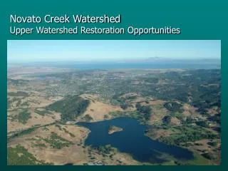
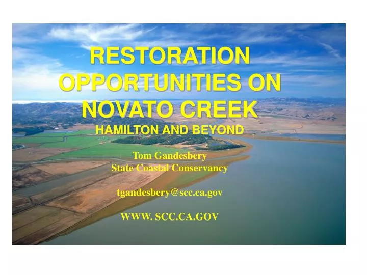
RESTORATION OPPORTUNITIES ON NOVATO CREEK HAMILTON AND BEYOND Tom Gandesbery State Coastal Conservancy tgandesbery@scc.ca.gov WWW. SCC.CA.GOV. H/BMK Who is Involved?. Consulting Firms: PWA and Noble / NHC Marin County Flood Control / Public Works USACOE City of Novato

E N D
RESTORATION OPPORTUNITIES ON NOVATO CREEK HAMILTON AND BEYOND Tom Gandesbery State Coastal Conservancy tgandesbery@scc.ca.gov WWW. SCC.CA.GOV
H/BMK Who is Involved? • Consulting Firms: PWA and Noble / NHC • Marin County Flood Control / Public Works • USACOE • City of Novato • BMK CSD and several members of community • Water District • Sanitary Districts (2) • Home Owner’s Associations • Environmental Community • Trail Advocates • NOAA
Project is 3 Properties = 2600 acres Bel Marin Keys Homes BMK V 1600 ac -Owned by SCC NAF ~200ac Owned by SLC Airfield 622ac -Owned by SCC
LTMS ~ Hamilton Link Partners involved in: Pre-project planning (Since 1993) 1999 Congressional Approval of Hamilton Federal and State Appropriations Stakeholder Involvement (Local Gov and NGO) Fosters Collaboration: Work between agencies Support by Maritime Interest Groups
LTMS Strategy BCDC / USEPA / RWQCB / USACOE LTMS Program EIS/EIR (1994) and ROD (1999) Disposal and Reuse Goal of 40/40/20 20-Year Planning Horizon 40% Ocean Disposal 40% Reuse 20% In-Bay
Multiple Objectives • Marsh Restoration using Dredged Sediment • ( LTMS) • Tidal Marsh Habitat benefiting Endangered Species Part of a Larger Initiative (see map) Habitat Linkages With in USFWS / DGS Refuge System • Well Planned Reuse of Military Lands • BRAC No-Cost Conveyance to SCC
Total Project Conceptual Design • Scan pdf
Design Objectives Creation of 3 habitat types tidal wetlands seasonal wetlands uplands To benefit an array of species endangered (saltmarsh harvest mouse, clapper rail) shorebirds(e.g. greater yellowlegs, long-billed curlew) local wildlife (e.g. marsh hawk, voles, butterflies) With minimal long-term maintenance
Hamilton Wetlands Restoration Project Authorized in WRDA 1999 - $55,200,000 • Purpose: Ecosystem and Wetlands Restoration • Restores approximately 990 acres of habitat including: • 570 Acres of Coastal Salt Marsh • 120 Acres of tidal channels and intertidal habitats • Accommodates approximately 10.6MCY of dredged material • 13 years of Adaptive Management Post Breach • Complete Restoration – 20 Years Regardless of the availability of dredged material, the bay ward levee breach would be completed no later than 8 years after initiation of site preparation to ensure that marsh establishment would not be delayed
(After) Wave – Fetch Berms Pilot Channel (Mosquito Ditch)
Progress3 Major Phases For Airfield Built 3 out of five levee segments Seasonal Wetland Design ~50% complete Trail plan complete DM placement cells for first phase compete Major DM placement - start winter of 2007 2005 rec permits Monitoring required
Antenna Field Status 190 Acres ~ 30 Acres in southeast corner used for: Shooting range Antenna field Burn Pits (fire training, etc) Spot Removals completed in 1990s Clean-up Plans are in a regulatory process After remediation, restored as Phase II or III of the project Cleanup scheduled for 2008
BMKV Status • Awaiting Congressional Approval to Add to Hamilton (WRDA) • Elements completed: • Supplemental EIS/EIR for Bel Marin Keys Unit V • Completed December 2003. • General Reevaluation Report (GRR) a revision to the FS • Draft Chief’ Report written • Revised Cost Estimates
Toxics Remediation This is another Workshop! • Done by Army / Navy BRAC • 1990s - BRAC work within Hamilton • Contaminants typical of an large airport • $70 Million (about) on soil cleanup - no groundwater • Cleanup complete this FY • Cleanup plan adopted 2003 • Low level (residual) DDT in soilwas managed by project
Public Access • Trail will run western parameter of site • To BMK Blvd North and connect to ? South • User –wildlife interaction • Nesting birds most sensitive • Sophisticated Trail Design (Mixture of cable fencing,moat, signage, elevation) Required monitoring • Methods? • Applicable to Adaptive Management
The Project at HAAF Habitat Upland Tidal wetland Seasonal wetland Goal local wildlife endangered species shorebirds migratory species Physicalcorridor tidal action tidal inundation corollaries restricted access sedimentation ppt inputs escape terrain channel network/form high soil salinity Vegetation native overstory Salicornia open pannes, mixed understory stressed Salicornia, matrix of native wetland Challenges weeds design template design w/ man options inund/salinity regime weeds Uncertainty low low to moderate high
HighPrioritiesfor Monitoring Physical Placed sediment elevation (No overfilling!) Levee erosion and stability (flood control) Channel development Hydrology inside and outboard Chemical MeHg (Corps, Calfed) Conventionals and sediment (e.g. redox) Biological Bird use Clapper rail and SMH Mouse Fish use
Strategy Decision Design Design Adaptive Management: Monitoring specific to objectives, uncertainties Evaluation Evaluation Implementation salinity, indundation, veg, birds Monitoring Modified from Sit and Taylor 1998
HAAF ADAPTIVE MANAGEMENT CYCLES resource quality time
AVAILABLE STUDIES • Collins, L July 1998, Sediment Sources and Fluvial Geomorphic Processes of Lower Novato Creek Watershed. • Prunuski Chatham, Inc, April 2001, Novato Creek Watershed, Erosion Inventory and Sediment Control Plan • Phillip Williams and Associates, May 7, 2002, Flood and Sediment Study for Lower Creek (All are reports to or for Marin County Flood or PW) OTHERS?
Results of BMK H&H2 lead to…. • Confirms previous findings • Quantifies some parameters • Poses new questions • Like…. upstream flood routing • Influence of Black Point as tidal basin
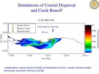
Novato Creek Hydraulic Modeling May 2006 northwest hydraulic consultants
Study Objective • Investigate potential hydraulic impacts to Novato Creek if BMK-V parcel is restored to tidal wetlands • Develop 1-d HEC-RAS model for existing conditions • Develop 1-d HEC-RAS model for project conditions • Conduct comparative simulations of different flooding scenarios with coincident high flow and tide
Study Area Novato Creek North Lock Bel Marin Keys development Bel Marin Keys Unit V (BMK-V) expansion site Pacheco Pond San Pablo Bay South Lock
Inflow Flood Hydrographs • Novato Creek • USACE 100-yr peak flow 6,230 cfs • 100-yr peak flow 8,000 cfs • 10-yr peak flow 3,420 cfs • Arroyo San Jose • 100-yr peak flow 2,403 cfs • 10-yr peak flow 1,340 cfs • Pacheco Creek • 100-yr peak flow 1,041 cfs • 10-yr peak flow 582 cfs
Modeling Scenarios 19 flood and geometric scenarios: • 100-year river flood & 10-year tide • Existing conditions (Baseline/No bridges/Leveroni levee breach/Accreted) • Project conditions (Project/No bridges/Leveroni levee breach) • 10-year river flood & 100-year tide • Existing conditions (Baseline/No bridges/Leveroni levee breach) • Project conditions (Project/No bridges/Leveroni levee breach) • 100-year river flood & 100-year tide • Existing conditions (Baseline/No bridges/Leveroni levee breach) • Project conditions (Project/No bridges/Leveroni levee breach)
Modeling Results –100-year flood & 10-year tide • Flooding pattern Existing Project
Modeling Results –10-year flood & 100-year tide • Flooding pattern Existing Project