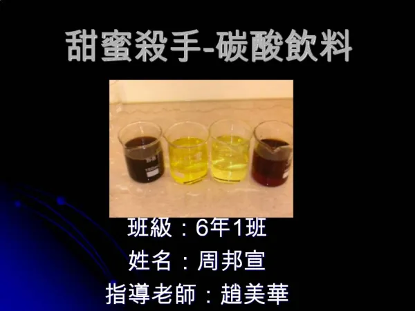
Download
1 / 47
470 likes | 622 Vues
MET 61. Topic 3 Weather Systems. Extratropical cyclones a.k.a. Mid-latitude storms Storms have characteristic: Spatial scales Time scales Speeds (of storm motion) Structures Lifecycles Behavior.

E N D
MET 61 Topic 3 Weather Systems MET 61 topic 03b
Extratropical cyclones • a.k.a. Mid-latitude storms Storms have characteristic: • Spatial scales • Time scales • Speeds (of storm motion) • Structures • Lifecycles • Behavior MET 61 topic 03b
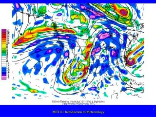
The “Norwegian Cyclone Model” of these storms was developed in the early 1900’s based on observations. http://en.wikipedia.org/wiki/Norwegian_cyclone_model http://en.wikipedia.org/wiki/Extratropical_cyclone MET 61 topic 03b
Object in §8.1 is to use a case study to characterize: • Spatial distributions of: • Winds • Pressures • Temperatures • Fronts • Clouds • “weather” MET 61 topic 03b
characterize: • Temporal variations of: • Parameters as a storm travels west east • Storm’s evolution as it travels west east • Horizontal structure @ surface and aloft • Vertical structure MET 61 topic 03b
Much of this will be seen again in 170A,B and 171A,B Some material will already be familiar to some of you! Material: • Figures in §8.1 • Text • Summary notes (handout) MET 61 topic 03b
Convective storms • Text §8.3 • We are interested in DEEP convection (Cb – rather than simple Cu) • Tends to occur in preferred locations: • E.g., US midwest; ITCZ • associated with frontal systems (provide dynamics for lift) MET 61 topic 03b
influenced by geography (Gulf, Rockies) • e.g., http://www.weather.gov/outlook_tab.php • VIP for summer rainfall over the midwest • e.g., http://www.climate-zone.com/climate/united-states/iowa/des-moines/ MET 61 topic 03b
Smaller-scale phenomena, so depth scale length scale • Strong vertical motions • Compare to synoptic-scale storms! MET 61 topic 03b
We can identify: • Individual convective storms (“single cell storms”) • Multicell storms • Mesoscale convective systems – larger systems MET 61 topic 03b
Required environmental conditions: • Conditionally unstable atmosphere w < d • Boundary layer moisuture available • Mechanism to give low-level convergence → lift MET 61 topic 03b
Conditionally unstable atmosphere • If we can lift an air parcel to the level of free convection (LFC), it will ascend on its own to the equilibrium level (EL) {where T(parcel) < T(environment)} • As air rises, potential energy → kinetic energy {associated with w2/2} MET 61 topic 03b
We define convective available potential energy (CAPE) as follows: MET 61 topic 03b
CAPE is just the area on a skew-T between the sounding and a moist adiabat • Example 8.1 shows typically CAPE value of almost 4000 J kg-1 • See http://en.wikipedia.org/wiki/Convective_available_potential_energy MET 61 topic 03b
CAPE can be computed in multiple ways: • CAPE computed from LFC EL (as defined above) • MLCAPE = Mean Layer CAPE = CAPE calculated using a parcel consisting of Mean Layer values of temperature and moisture from the lowest 100 mb above ground level. • SBCAPE = Surface Based CAPE = CAPE calculated using a surface-based parcel. MET 61 topic 03b
CAPE criteria for severe weather (CAPE computed thru the column): • CAPE < 1000 J kg-1 convection chances marginal • 1000 < CAPE < 2500 J kg-1 moderate convection • 2500 < CAPE < 4000 J kg-1 extreme convection MET 61 topic 03b
CAPE and CIN • CAPE is stored energy • We need large values of CAPE stored up since CAPE kinetic energy (“w”) • Accomplish via a stable layer capping the boundary layer • Inhibits vertical motions until some break through • Thus – allows CAPE to build up (as opposed to “bleeding out”) • These then “eat into” the store of CAPE → deep convection • (see “animations: CAP strength vs CAPE”) MET 61 topic 03b
We can define a “negative CAPE” or “anti CAPE” as CIN = convective inhibition • CIN > 1000 J kg-1 convection unlikely • Daytime heating over land (versus oceans) deep convection more pronounced over land vs. water • Fig. 6.56 = lightning!!! MET 61 topic 03b
Vertical wind profile • From above, we know there must be CAPE • CAPE is associated with vertical profiles of temperature and humidity • There are also wind profile requirements needed for convective activity • More later… MET 61 topic 03b
Storm speed • Storms move at same speed as a vertically-averaged horizontal speed • We talk of a “steering level” but…(p.347) • Storms can move to the left or right of the steering level flow! MET 61 topic 03b
Storm structure vs winds • Weak vertical shear {where V/z is weak} favors airmass thunderstorms (non-severe) – see below • Stronger vertical shear favors multicell and supercell storms – more severe MET 61 topic 03b
Above relates to speed shear • There can also be directional shear • This can contribute to vorticity enhancement • This can aid the development of rotation in a storm • This can be a precursor to tornadoes! MET 61 topic 03b
Ingredients for deep convection in US • Conditional instability…aided by: • Southerly flow of warm, humid low-level air from the Gulf of Mexico • Westerly flow of dry, conditionally unstable air aloft (source = Rockies to the west) • Strong vertical wind shear • Southerly low-level flow; westerly upper-level flow (veering winds) • Mechanism to create lift • Example: frontal approach MET 61 topic 03b
Structure of deep convection • We think of cells of convection • Cells consist of multiple parcels • Cells grow upward, “eating into” CAPE • Eventually bump into the tropopause → anvil structure • Ice clouds at this level (Ci) MET 61 topic 03b
Single cell storms • Also called airmass thunderstorms • Non-severe • Typical of what we might see over western deserts in summer (NV, AZ) • Arise from local convective instability – do not need to be forced by fronts MET 61 topic 03b
A single cell which → distinct lifecycle • See Fig. 8.48 Cumulus stage • Rising warm, moist air plume + entrainment • w 10 m/s @ top • Top of cloud above FZL • Supercooled droplets MET 61 topic 03b
Mature stage • Precipitation drops large enough to fall out have formed • A strong downdraft develops • Rain droplets + air fall out of cloud (frictional drag) • Falling drops evaporate → evaporative cooling • Thus a cold air downdraft develops • Rain + cold downdraft @ base of cloud MET 61 topic 03b
Dissipating stage • Most of the cloud is now occupied by the downdraft • No more updraft = no more cloud & precip development • Storm is “choked off” Duration - about an hour Non-severe (e.g., no large hail) Can/will have lightning/thunder “animations” MET 61 topic 03b
Multi-cell storms • Consist of a series of cells • Develop in sequence • Development of one aids the development of the next one • Hence storms are more long-lived (several hours) MET 61 topic 03b
Vertical wind shear is crucial: • Airmass thunderstorms form in weak/no vertical shear updraft & downdraft are not separated • With vertical shear, the updraft can become tilted in the vertical • And the updraft and downdraft can now coexist MET 61 topic 03b
As one cell develops, there is: • Upward growth • Development of precip in the updraft • Growth of large precip droplets which begin to fall out • Development of a cold downdraft in a separate region from the updraft – see Fig. 8.49 • Cold downdraft → Gust Front of cold air @ surface • This gust front provides additional lifting for the development of the next cell! • Hence – the process can continue! • “animations” MET 61 topic 03b
Note that air rises and exits the system @ upper levels ahead of the storm • Air enters @ mid-levels to the rear of the storm! MET 61 topic 03b
Supercell storms • Characterized by a rotating updraft • Most tornadoes come from these • http://www.weather.gov/glossary/index.php?word=supercell+thunderstorm MET 61 topic 03b
Rotation induces a mesolow … small-scale low pressure center which enhances winds (horizontal and vertical) • These storms are short-lived so Coriolis effects are small and can be ignored • As a result, the force balance is between the pressure gradient force (PGF) and the centrifugal force (CE) cyclostrophic wind with: MET 61 topic 03b
Ex. 8.3 typical p/n of 1 mb/km • Larger pressure gradient stronger winds • Convergence (induced by surface friction) rising motions • Ex. 8.4 vertical acceleration of 0.1 m/s per second 6 m/s vertical motion within one minute! MET 61 topic 03b
Development of storm & rotation • Fig. 8.52 • Assume only SPEED SHEAR • Speed shear {u/z} rotation in a horizontal “tube” of boundary layer air (8.52a) • As this “tube” is fed into the updraft, the rotation becomes oriented about the vertical axis (“vorticity”) MET 61 topic 03b
These induce pressure perturbations (cannot have winds w/o pressure perturbations) associated with each vortex • This makes the storm split into two supercells • Radar example: http://epod.usra.edu/blog/2008/05/splitting-supercell.html MET 61 topic 03b
So we get a right-moving storm (“R”) and a left-moving storm (“L”) • “R” means moving in a direction to the right of the mean wind (and vice versa) • Note the opposite orientations of the two rotating updrafts (clockwise versus CCW) • With only speed shear, they are equally likely • In reality? MET 61 topic 03b
In reality? Depends on wind direction shear with height. • We examine a hodograph to tell us this MET 61 topic 03b
north 700 mb Example… 900 mb 1000 mb west 500 mb Now…connect the ends of the wind “arrows” hodograph MET 61 topic 03b
north 700 mb Resulting hodograph (blue line)… 900 mb 1000 mb west 500 mb General case: speed and direction change with height MET 61 topic 03b
north Resulting hodograph (blue line)… 800 900 west - Special case: speed shear only (straight line hodograph) - Favors splitting into 2 symmetric storms MET 61 topic 03b
north 700 mb Resulting hodograph (blue line)… 900 mb 1000 mb west 500 mb • Winds veering with height clockwise-turning hodograph • Favors right-moving storms (observed…theory???) • This is typical of the southern plains MET 61 topic 03b
Net result: • Right-moving storms favored when winds veer with height (left-moving storms suppressed). MET 61 topic 03b
Storm structure • Fig. 8.54 (right-mover) • Bounded weak echo region (BWER) • Indicates updraft • Heaviest rain “behind” (p.355) MET 61 topic 03b
Storm structure • Fig. 8.55 = surface “map” • Mesocyclone (“L”) • Gust front • Enhances uplift • Also enhances shear and thus “spin” generation MET 61 topic 03b
Tornadic storm structure • Fig. 8.56 = tornadic storm • Difficult to measure!!! • Hook echo • http://en.wikipedia.org/wiki/Hook_echo • Read 8.3.3 (tornados, downbursts, derechos) and 8.3.4 (MCCs) yourselves MET 61 topic 03b