Download
1 / 26
260 likes | 442 Vues
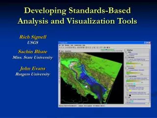
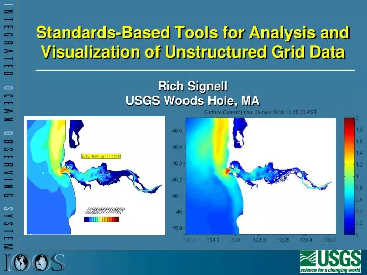
Standards-Based Tools for Analysis and Visualization of Unstructured Grid Data. Rich Signell USGS Woods Hole, MA. US Integrated Ocean Observing System (IOOS ® ). IOOS ® Plan defines: Global Component Coastal Component 17 Federal Agencies 11 Regional Associations .

E N D
Standards-Based Tools for Analysis and Visualization of Unstructured Grid Data Rich Signell USGS Woods Hole, MA
US Integrated Ocean Observing System (IOOS®) • IOOS® Plan defines: • Global Component • Coastal Component • 17 Federal Agencies • 11 Regional Associations
IOOS approved services for Gridded Data and Model Outputs satellite HF radar gridded model outputs Table of Contents Data Provider OPeNDAP/CF OGC WCS (Web Coverage Service) Data Values Quality Control Metadata CF Metadata
Ocean models are often not regularly spaced! Curvilinear orthogonal horizontal coordinates Stretched surface and terrain following vertical coordinates
Climate and Forecast (CF) Metadata Conventions Groups adopting CF: GO-ESSP: Global Organization for Earth System Science Portal IOOS-DMAC: Integrated Ocean Observing System ESMF: Earth System Modeling Framework OGC: Open Geospatial Consortium (via WCS netcdf encoding)
Unidata Common Data Model Data access layer, handles data reading and writing. Coordinate system layer identifies the coordinates of the data arrays. We also identify specialized georeferencing coordinate systems, which are important to the Earth Science community. Scientific feature type layer identifies specific types of data, such as grid, radial, and pointdata
NJ Toolkit for Matlabhttp://njtbx.sourceforge.net • Objective: Make it simple to access CF data • Example function: • [t, geo]=nj_tslice(URL,’temp’,1); • t = 22x120x180 single • geo = • lat: [120x180 single] • lon: [120x180 single] • z: [22x120x180 double] • time: 733582 (matlabdatenum) • nj_tslice works identically for ROMS, POM, ECOM, WRF, Wavewatch3 • URI can be: local NetCDF, remote NetCDF, NcML, OpenDAP Data URL
test_cf_ugrid.m ADCIRC FVCOM SELFE ELCIRC ZIRINO
Comparing Models with Data in Matlab Model 1: UMASS-ECOM Model 2: UMAINE-POM Data: SST 2008-Sep-08 07:32
14 Different Ocean Forecast Models Spanning CONUS Waters in IDV
Successes • Existing Unidata technology allowed for standards-based delivery of aggregated geospatial data from native model grids that put little or no effort on the data provider • Demonstrated interoperability with 17 THREDDS servers in 11 IOOS Regions • What did we get? • Single point of access for regional model results • Interoperable software • More eyes on the model results • More usage of model results • Faster feedback to modelers • Improved models • Increased community support for standards-based access
What Next? • Continue work on a high-level scientific toolbox for standardized access to model data. (Matlab toolbox based on NetCDF-Java) • Develop unstructured grid support: Common Data Model implemented in NetCDF-Java (meeting tomorrow to scope work plan!) • Work on discovery and documentation (harvesting metadata, enabling geospatial and faceted search, returning useful payloads)
What You can do! • Try out and give feedback on the NJ Toolbox: http://njtbx.sourceforge.net • Modify existing applications to read standards-based access via OPeNDAP • Join the dialog on the UGRID Google Group: • http://groups.google.com/group/ugrid-interoperability
Questions, Feedback? Rich Signell (508) 457-2229rsignell@usgs.gov
THREDDS • When people say “THREDDS”, they can mean a catalog or a data server • THREDDS Catalogs are XML files that define metadata, datasets and services • THREDDS Data Server is a Java data server application developed by Unidata, a simple and flexible way for delivering CF-compliant data via OPeNDAP
OPeNDAP • When people say “OPeNDAP”, they can mean protocol, a server, or an organization • OPeNDAP (or just DAP) protocol: a remote data access service protocol with multiple responses • DDS – describes the format of the data • DAS – describes associated attributes • DDX – XML response containing the DDS & DAS • DODS – the actual data • OPeNDAP server: a server capable of serving the DAP protocol (e.g. THREDDS Data Server, Hyrax, Pydap, GrADS Data Server) • OPeNDAP organization: Defines and maintains the DAP protocol, develops servers and clients, provide custom OPeNDAP solutions