Download
1 / 15
160 likes | 415 Vues
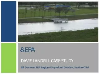
Banu Sizirici. DAVIE LANDFILL. MAPS. Vista View Park (Davie Landfill). Vista View Park (Davie Landfill). Boy Scouts of America campsite. N. Residential properties (Imagination Farms and Riverstone). Residential properties (Imagination Farms and Riverstone ). Landfill. W. E. S.

E N D
Banu Sizirici DAVIE LANDFILL
Boy Scouts of America campsite. N Residential properties (Imagination Farms and Riverstone) Residential properties (Imagination Farms and Riverstone) Landfill W E S Undeveloped land and a telemetry tower owned by the South Florida Water Management District Vista View Park (Davie Landfill)
Davie Landfill Chronology of Events 1964 Incinerator and trash landfill (south mound) operations commence November 1971 - Unlined sludge lagoon created and operations begin June 1975 - Shutdown of incinerator December 1987- Landfills at subject site officially close February 1995 - Solid Waste Post-Closure Permit issued by FDEP July 2003 - Vista View Park was opened the public
Davie Landfill General Information Orange Drive and N.W. 142nd Avenue Davie, Broward , Fl The site is a 209-acre parcel of land a 68-acre Class III landfill (south mound) a 48-acre Class I landfill (north mound) a nature pond (former sludge lagoon) Three borrow pit lakes in the eastern and southern sections of site.
Cap Feature A two-foot thick, compacted, limerock cover Six-inch layers with six inches of vegetative cover soil A total of 31,969 tons of limerock were used as landfill cover material, Two lifts of material, 1-foot thick, were spread and compacted to an in-place density of at least 98%. The final cover was sloped at a 2% Slopes generally 1 to 3%,
Leachate Liner Leachate from the sanitary Landfill Main sump City of Sunrise wastewater treatment plant. Leachate line is monitored at least twice per week for any unexplained pressure drops
Gas collection and monitoring 6 trench well headers 33 gas extraction wells collects gases eliminates them through an enclosed flare inspected and maintained on a monthly basis
Surface water Site is located between North New River Canal and The South New River Canal (C-lI), The east of the landfill drains into the C-ll Canal All surface water runoff is channeled to borrow lakes The southern area drains to lake number 3.
Ground water The well clusters are comprised of three monitoring wells at different depths 7 groundwater monitoring well clusters (numbered 3, 7, 8, 9, 11, 21 and 22) are sampled semiannually. Cluster #22 serves as the background well cluster, and clusters #11 and #21 are down gradient well clusters. Cluster #11, which is comprised of four monitoring wells at different depths
Boy Scouts of America campsite. N Residential properties (Imagination Farms and Riverstone) Residential properties (Imagination Farms and Riverstone) Landfill W E S Undeveloped land and a telemetry tower owned by the South Florida Water Management District End Use The surrounding area is primarily residential, with some commercial uses.