Download
1 / 56
560 likes | 730 Vues
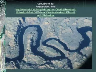
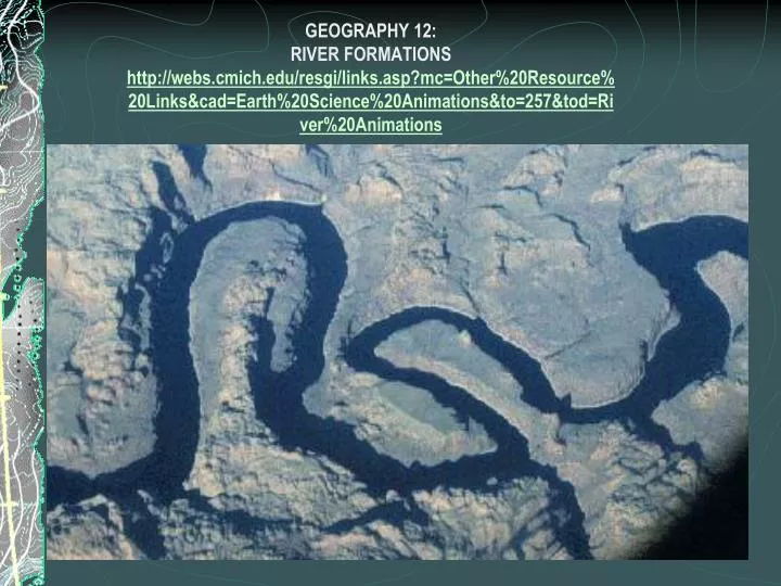
GEOGRAPHY 12: RIVER FORMATIONS http://webs.cmich.edu/resgi/links.asp?mc=Other%20Resource%20Links&cad=Earth%20Science%20Animations&to=257&tod=River%20Animations. All part of the hydrologic cycle. http://polaris.umuc.edu/cvu/envm/hydro/hydro.html `.

E N D
GEOGRAPHY 12:RIVER FORMATIONShttp://webs.cmich.edu/resgi/links.asp?mc=Other%20Resource%20Links&cad=Earth%20Science%20Animations&to=257&tod=River%20Animations
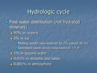
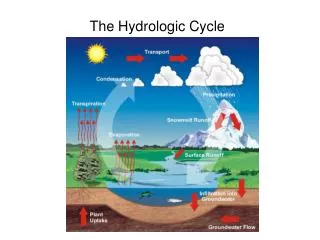
All part of the hydrologic cycle http://polaris.umuc.edu/cvu/envm/hydro/hydro.html `
DRAINAGE BASIN: an area of land from which a stream gets its water supply. It is a region that is grained by a single riverWhat type is seen below?
DendriticA branching treelike drainage pattern. In areas of uniform rock, with little distortion by folding or faulting, the rivers develop a random branching network similar to a tree
TrellisA rectangular drainage pattern. It occurs when the rock structure steers streams into a parallel course, with tributaries joining at almost right angles..
Radial A spokelike pattern of rivers. These tend to flow away from the summit of a dome or volcano in all directions.
Following a river The Rhine River
Youthful River • Youth stage-cuts a deep V-Shaped valley as the fast moving water transports material downstream. Dominated by erosion and very little depositionfeatures: include rapids, waterfalls, and various sizes of boulders along the river bed.
Mature Stage • Mature Stage: Drainage pattern is evident. Vertical erosion is evident, but downstream lateral erosion of banks is evident as meanders and a flood plain take shape. Velocity slows and deposition is common. • Deposition>erosion
Old Stage • Old Stage: Extensive floodplain and meandering occur. River cuts across meanders to create oxbox lakes. Flooding of rich alluvium and natural levees are prominent. The river delta is well developed and continues to grow. • Flooding deposits rich alluvium (sand, silt, and clay for farming) with natural levees along river banks
Rejuvenated River • Rejuvenated Stage-The land has undergone a slow uplifiting and caused the river to return to a period of vertical erosion as was the case in the youthful stage • Deep v-shaped valley prominent • River cuts through the floodplain created until its elevation nears sea level
Work of rivers 3 functions • Erosion • Transportation • Deposition http://www.bbc.co.uk/schools/gcsebitesize/geography/coastal/coastalprocessesrev4.shtml
Transportation http://library.thinkquest.org/28022/transport/index.html
RIVER EROSION AND DEPOSITION: Cut off slope aka cutbank Point bar or slip off slope
Stream Meandering • Graded streams may erode horizontally in process called meandering • Cutbanks form on outside of meanders (fast), while point bars form on the inside (slow) Stream Meandering
Formation:When meander bends become giant loops, there is a thin piece of land left between the beginning and the end of the meander. This is the meander neck.
As the river neck becomes very narrow, the river can break through. For a short time, water flows both round the meander (which is now called a backwater) and across the meander neck.
Eventually the river cuts off the backwater completely and flows across what used to be the meander neck. For a short time, an oxbow lake is left behind.
The oxbow lake lasts until it becomes overgrown with weeds and filled in with soil. This happens quite quickly as it is cut off from the main river and therefore doesn't get any water. This is called a MEANDER SCAR
Oxbow lakes on a topographic map:http://www.sln.org.uk/geography/oxbow/
Levees form by the spill-over of sediment during floods. Next to the channel most of the coarse sediment is deposited and finer muds and clays are deposited farther away. Thus, over time these near-channel sand deposits will rise above the floodplain and form natural levees. Extends into a terrace over time-Let’s watch an animation!
River Deltas • A river carries sediment from its drainage basin toward the seaends up being deposited on the floodplain when the stream flow slows down. • Some deposits are light enough to be deposited in the sea. • They form river deltassand is deposited closest to shore (heaviest), followed by silt and clay (lighter) • Below is an image of the Fraser River Deltaestuarine river delta
ARCUATE DELTA: Has many distributaries that carry water and sediment across a very symmetrical delta that has the shape of an inverted cove ex.NILE RIVER DELTAnumber of distributaries flowing across the delta (eg the Nile delta). An arcuate delta forms when a river meets the sea in a place where the waves, currents, and tides are strong