Download
1 / 1
10 likes | 152 Vues
Objective Boundary Detection in the Eastern United States – Sea-Breeze and Coastal Fronts, and Back-Door and Side-Door Cold Fronts. Joseph J. Charney USDA Forest Service Northern Research Station, East Lansing, MI. Daniel Keyser Department of Earth and Atmospheric Sciences

E N D
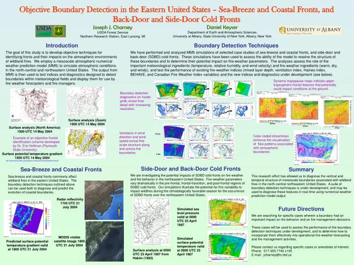
Objective Boundary Detection in the Eastern United States – Sea-Breeze and Coastal Fronts, and Back-Door and Side-Door Cold Fronts Joseph J. Charney USDA Forest Service Northern Research Station, East Lansing, MI Daniel Keyser Department of Earth and Atmospheric Sciences University at Albany, State University of New York, Albany, New York Introduction The goal of this study is to develop objective techniques for identifying fronts and their impacts on the atmospheric environments of wildland fires. We employ a mesoscale atmospheric numerical weather prediction model (MM5) to simulate atmospheric conditions in the north-central and northeastern United States. The output from MM5 is then used to test indices and diagnostics designed to detect boundaries within meteorological fields and display them for use by fire weather forecasters and fire managers. Boundary Detection Techniques We have performed and analyzed MM5 simulations of selected case studies of sea-breeze and coastal fronts, and side-door and back-door (SDBD) cold fronts. These simulations have been used to assess the ability of the model to resolve the structure of these boundaries and to determine their potential impact on fire-weather parameters. The analyses assess the role of the important meteorological ingredients (temperature, relative humidity, and wind velocity) and fire-weather ingredients (warm, dry, and windy), and test the performance of existing fire-weather indices (mixed layer depth, ventilation index, Haines index, BEHAVE, and Canadian Fire Weather Index variables) and the new indices and diagnostics under development (see below). Dynamic tropopause maps indicate upper-tropospheric frontal features that potentially could impact conditions at the ground. Boundary detection diagnostics on model grids reveal finer detail with increasing resolution. Surface analysis (Zoom) 1500 UTC 14 May 2004 36 km 12 km Surface analysis (North America) 1500 UTC 14 May 2004 4 km Variations in wind direction and wind speed reveal fine-scale structure along and across the boundaries. 12 km Color-coded streamlines enhance the visualization of flow patterns associated with atmospheric boundaries. Example of an objective frontal identification scheme developed by Dr. Eric Hoffman (Plymouth State University). Surface potential temperature gradient 1500 UTC 14 May 2004 http://www.atmos.albany.edu/gopher-local/surface/theta/00latest.theta.gif 4 km Side-Door and Back-Door Cold Fronts Sea-Breeze and Coastal Fronts Summary This research effort has allowed us to diagnose the vertical and temporal structure of mesoscale boundaries associated with wildland fires in the north-central northeastern United States. A suite of boundary detection techniques is under development, and may be used to diagnose these features in real time using numerical weather prediction model output. Future Directions We are searching for specific cases wherein a boundary had an important impact on fire behavior and on fire management decisions. These cases will be used to assess the performance of the boundary detection techniques under development, and to determine how to incorporate them effectively into operational fire-weather forecasting and fire management activities. Please contact us regarding specific cases or anecdotes of interest: Phone: 517-355-7740 x105 E-mail: jcharney@fs.fed.us We are investigating the potential impacts of SDBD cold fronts on fire weather and fire behavior in the northeastern United States. Fire-weather parameters vary dramatically in the pre-frontal, frontal-transition, and post-frontal regions of SDBD cold fronts. Our simulations illustrate the potential for this variability to impact wildfires during the climatologically favorable season for the occurrence of SDBD fronts over the northeastern United States. Sea-breeze and coastal fronts commonly affect wildland fires in the eastern United States. The boundary detection techniques outlined above can be used both to diagnose and predict the evolution of coastal boundaries. Radar reflectivity 1745 UTC 21 July 2004 Simulated sea level pressure valid at 0000 UTC 23 April 1987 MODIS visible satellite image 1805 UTC 21 July 2004 Simulated surface potential temperature valid at 0000 UTC 23 April 1987 Predicted surface potential temperature gradient valid at 1800 UTC 21 July 2004 Surface analysis at 0000 UTC 23 April 1987 from Hakim (1992)