Download
1 / 26
270 likes | 560 Vues
Satellite Data Assimilation at the U.S. Air Force Weather Agency JCSDA Science Workshop 2009 John Zapotocny Chief Scientist. Approved for Public Release – Distribution Unlimited. Overview. Mission Overview Products & Services Organization Meteorological Models

E N D
Satellite DataAssimilation at theU.S. Air ForceWeather AgencyJCSDA Science Workshop 2009John ZapotocnyChief Scientist Approved for Public Release – Distribution Unlimited
Overview • Mission Overview • Products & Services • Organization • Meteorological Models • Clouds and Surface Characterization • Regional scale NWP • JCSDA projects
Mission Overview A Global Team for the Global Fight Maximizing America’s Air, Space, Cyberspace, and Land Power by enabling decision makers to exploit relevant environmental information across the full spectrum of warfare. 3
Mission Overview Who We Support National Decision Makers Air Force and Army Warfighters Base and Post Weather Units Coalition Forces 4
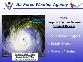
AFWA Organization FOA Commander Offutt AFB, Neb. ~1400 Total Personnel Model Devel & Ops 1st Weather Group Offutt AFB A – Staff Offutt AFB 2nd Weather Group Offutt AFB 2nd WS Offutt AFB 25th OWS D-M AFB, Ariz. 15th OWS Scott AFB, Ill. 2nd SYOS Offutt AFB AF Combat Weather Center Hurlburt Fld, FL 26th OWS Barksdale AFB, La. 14th WS Asheville, N.C.
Meteorological ModelsClouds and Surface Characterization • Clouds • Cloud Depiction and Forecast System (CDFS) II • World-wide Merged Cloud Analysis generated hourly • Global and regional cloud forecasts • Stochastic Cloud Forecast Model (SCFM) - Global • Diagnostic Cloud Forecast (DCF) - Regional • Surface characterization • Land Information System (LIS) • Soil moisture • Snow depth, age, liquid content • Soil temperature
GFS Upper Atmos. Temp Near Surface Temp/RH/Wind Surface Observations Snow Analysis Resolution: 12 nmi Obs: Surface, SSM/I Freq: Daily, 12Z World-Wide Merged Cloud Analysis (WWMCA) Hourly, global, real-time, cloud analysis @12.5nm Total Cloud and Layer Cloud data supports National Intelligence Community, cloud forecast models, and global soil temperature and moisture analysis. Surface Temp Analysis Resolution: 12 nmi Obs: IR imagery, SSM/I Temp Freq: 3 Hourly Global Cloud Analysis SystemCloud Depiction and Forecast System II Geostationary Data Polar Orbiting Data Cloud Height • DMSP • AVHRR • Future NPOESS Supports Visible Cloud Detection Supports IR Cloud Detection 10
Cloud Forecast ModelsStochastic Cloud Forecast Model SCFM • Global cloud cover model developed by 2 WXG (Dr. Dave McDonald) • Pairs GFS Temp, RH, VV, and Surface Press. with WWMCA cloud amounts • 16th mesh Polar Stereographic projection • 5 vertical layers • 3-hr time step • 84 hr forecast • SCFM products: • Total fractional cloud coverage • Layer coverage (5-layers) • 500 meter AGL, 850mb, 700mb, 500mb, 300mb layers 11
Cloud Forecast ModelsDiagnostic Cloud Forecast DCF • Regional cloud cover model developed by AFRL (Don Norquist) • Pairs AFWA WRF output with CDFS-II WWMCA analysis • Statistically “chooses” which clouds best correlate with WRF “predictors” • 45/15/5 km WRF grids & global ½ degree GFS grid • 3-hr time step • 30 to 80 hr forecast (depends on grid) • DCF products: • Total fractional cloud coverage • layer coverage (5-layers) • layer top height & thickness • layer type 12
Satellite Data Land Information System Satellite Data is Primary Input Inputs Physics Outputs Applications Topography, Soils WRF Theater Forecasts Army/AF Tactical Decision AidSoftware Crop Forecasts NCEP Soil Moisture & Temperature Land Surface Models Land Cover, Vegetation Properties Evaporation Meteorology Runoff Data Assimilation Modules Snowpack Properties Snow Soil Moisture Temperature 13
Meteorological ModelsRegional Scale NWP Weather Research and Forecast (WRF) model • Development agent is NCAR • Improved forecast capability over MM5 to better meet warfighter requirements • Implemented for classified support Jul 06 • Unclassified transition to WRF ongoing • AFWA WRF DA system • Currently 3DVAR (WRFVAR) • Transition to GSI underway Surface temperature and heat stress forecasts, 20 Jul 2007, 06Z cycle 10,0000 FT MSL Turbulence forecasts, 20 Jul 2007, 06Z cycle
AFWA WRF WindowsProposed Configuration Central America, North Africa, and South Asia are 20km; all other parent windows are 15km. 15
JCSDA Projects • DoD requirements demand improved cloud, aerosol, and surface trafficability forecasts • JCSDA Projects underway to: • Enhance cloud height and type specification • Improve accuracy of cloud forecasts • Couple land/air model assimilation and forecasts • Improve accuracy/resolution of cloud, land, dust, and regional NWP models • Long-Term Goal is coupled/unified data assimilation and forecast system • AFWA Coupled Analysis & Prediction System
JCSDA Projects High Fidelity Cloud & Aerosol Characterization are Driving Requirements Layers of Model (1 x 1 km grid spacing) Modeled Clouds Modeled Aerosol (Dust) DUST • Spatial resolution: Horizontal: 1 x 1 km, Vertical: # of layers in model (SFC to 10mb) • Temporal resolution: 1hr steps for 0-12hrs, 3hr steps for 12-24hrs, 12hr steps for 24-72hrs • Quantify aerosol/cloud “amount” on 1km grid for each layer of model • Predict slant path (visible/IR) detection by integrating layered cloud/aerosol forecasts • For visual acquisition, output defaults to CFLOS-like product that accounts for aerosols as well as clouds. • For IR acquisition, output defaults to TDA product since we must account for sensor type, target temp, • background temp, etc. in addition to slant path clouds, aerosols. 17
WWMCA vs. CloudSAT Cloud Coverage CloudSat Observed WWMCA Analyzed 18
1557 UTC Wed 5 Jun 05North Pole Summer Snow Ice Water-droplet cloud Ice-particle cloud Cloud Phase, Snow, Ice Mask Visible - near-IR composite Cloud Mask Cloud Optical Properties Essential to EO Targeting 19
AIRS Cloud RetrievalHyperspectral DA for Cloud Specification 300 280 260 240 220 Retrieved vs. measured cloudy AIRS spectra AIRS 11-μm brightness temperature (K) RetrievedObserved Retrieval with CRTM achieves close match with measurements Tracks transition from clear to cloudy 20
RMSE of 36hr Forecastsover SWA w.r.t. Sondes COSMIC Impact in WRF • WGPS_10mb vs. WGPS: • Moving the model top to 10mb decreases the RMSE of U and T forecasts in the stratosphere. • WGPS_250mb vs. WGPS & WGPS_250mb vs. NOGPS: Assimilation of COSMIC data only in troposphere sustains positive impacts in troposphere and decreases the RMSE of T forecasts in stratosphere as shown in WGPS. NOGPS WGPSWGPS_250mb WGPS_damp3 WGPS_10mb • WGPS_damp3 vs. WGPS: The enhanced damping at the model top only marginally changes the RMSE of T(U) forecasts.
Precipitation AnalysisLIS Enhancement Use high resolution climatology (PRISM) to constrain satellite precipitation observations TRMM Estimate High-Resolution Climatology Downscaled precipitation analysis • Increasing reliance upon space-based precipitation observations PRISM Group on the web– http://www.prism.oregonstate.edu 22
LIS-WRF CouplingAFWA, NASA Joint Project LIS initialized runs were able to reduce WRF warm bias LIS affected 0-48 hour fcst variables of surface weather, boundary layer, cloud, and precipitation LIS soil and snow fields capture fine scale surface features, reflecting important role in high resolution NWP • Demonstrate and evaluate using LIS to initialize WRF SE Asia domain • 4 seasonal test case periods • Coupling via ESMF STUDY RESULTS: 23
AF Cloud Profiling Radar: Ka-band AFRL radar Data courtesy of Atmospheric and Environmental Research, Inc. Cloud Optical PropertiesInitial Comparisons AER, Inc. Ice Water Content compared to Radar Returns • New GOES-based algorithms improve cloud top height assignment • AFWA implementing new algorithms in CDFS II • Added benefits • Improved analysis will improve cloud predictions from DCF, SCFM, & ADVCLD 24
Long-Term Conceptual Design Unified Weather Analysis and Prediction System Satellite Data Global Cloud Information Mobility apps Global SnowInformation NWP initialization Target Identification High resolution physics based Cloud forecasts GlobalSurface Albedo Support CFLOS tools More accurate Weather forecasts Directed Energy & TCA support Data Data Forecast Atmospheric Data Assimilation System (4D-VAR) Coupled 25