Download
1 / 11
110 likes | 306 Vues
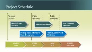
Project Schedule. Project advisory committee meeting. Public Open House. South Beach Study Area. 32 nd Street. From Yaquina Bay Bridge south to SW 62 nd Street. 35 th Street. Ash Street. 40 th Street. 50 th Street (Current alignment). South Beach State Park.

E N D
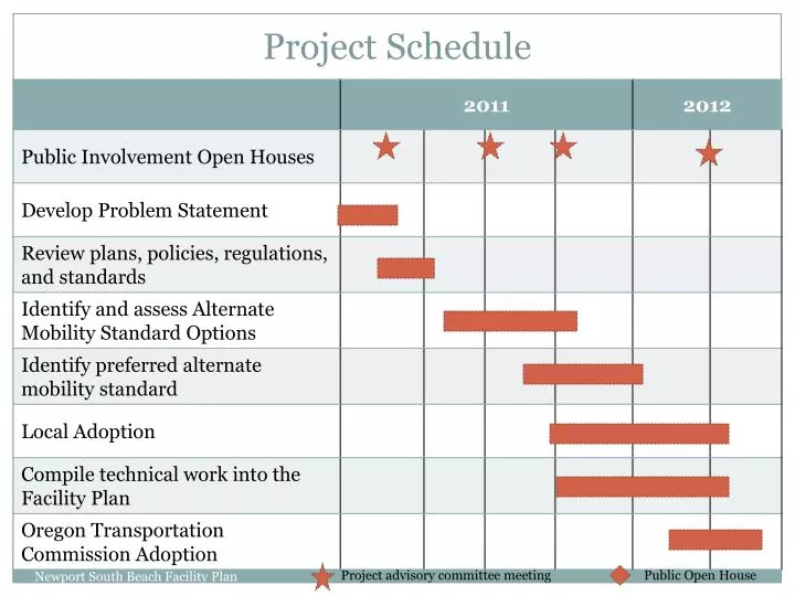
Project Schedule Newport South Beach Facility Plan Project advisory committee meeting Public Open House
South Beach Study Area 32nd Street From Yaquina Bay Bridge south to SW 62nd Street 35th Street Ash Street 40th Street 50th Street (Current alignment) South Beach State Park 50th Street (New alignment) 62nd Street Newport South Beach Facility Plan
Future Traffic Conditions: Year 2030 • The Yaquina Bay Bridge constrains traffic on US 101. Today, on summer weekends and on special fishing seasons such as opening day for halibut. At planning horizon, the bridge will be a constraint much more frequently. • Significant congestion and delays, especially in summer, expected to exceed 2012 ODOT mobility targets. • Conditions closer to the bridge expected to be worse. • Highway traffic demand near bridge could exceed highway capacity up to 8 hours per day during summer. • Even with improvements, traffic would exceed 2012 OHP mobility targets. Newport South Beach Facility Plan
Traffic Growth • Future development adds about 3,900 trips by 2030 • 70% of new trips assumed to head north, 30% south. • Major improvements to US 101 and local system needed to support development. Newport South Beach Facility Plan
Assumed Improvements on US 101 Projections of future traffic conditions assume the following projects will occur (some are funded through the URD, others are unfunded): • Intersection upgrades including new traffic signals • US 101 widening (4 lanes) • Off-highway local roadway connections Newport South Beach Facility Plan
Funding: How will projects be paid for? • South Beach Urban Renewal District • Anticipated $5 Million over 20 years to pay for projects in URD Plan • ODOT/FHWA • No funding is known at this time • Property Developers • Frontage improvements; local network improvements • What about the Yaquina Bay Bridge? • No funds currently identified to address this need Newport South Beach Facility Plan
Alternate Mobility Standards • Management tool to balance land development and traffic congestion on US 101 • Allows more traffic congestion given lack of funds for major highway projects • Provides greater predictability for developers and the City about acceptable level of land development • Creates an agreement among City, County, and ODOT about future growth in South Beach. • Replaces current stop-gap management of S 40th Street. Newport South Beach Facility Plan
Alternate Mobility Standards: Goals & Objectives • Traffic Mobility – Optimize travel reliability • Provides expectation for summertime tourist season and off-season congestion along US 101. • Accessibility • Provides an interconnected network of off-highway streets for local travel and property access. • Land Development Predictability • Provides a common understanding among the jurisdictions, land owners and developers. • Flexibility – adaptable to changing conditions • Allow for monitoring and periodic updates to adjust traffic and population assumptions • Ability to fund • Link facility improvements with property development. Newport South Beach Facility Plan
Location: Where will the standards be implemented? At signalized intersections? Unsignalized intersections? All intersections? A corridor standard? Separate directional standards (north vs. south)? Analysis Period: What time period is to be used? The summer time weekday peak hour (high congestion)? The annual average traffic (comparable to May or October)? Off-season peak? When are the Standards Implemented? At adoption? When roadway projects are completed? When intersections are signalized and upgraded? Allowed Congestion Level: What will the level of congestion be? Extremely congested and over capacity? Somewhat congested? Similar to current standards? Land Use Policy Changes: How can development in South Beach be managed so that it does not exceed the alternate mobility standard? Trip caps? Trip budgets? Overlay zones? Phased development? Alternate Mobility Standards: Common Elements Newport South Beach Facility Plan
Location: Where will the standards be implemented? At signalized intersections. Measured at SE32nd Street now; at S 35th, S 40th and SE 50th /South Beach State Park in the future Analysis Period: What time period is used for analysis? The annual average traffic (shoulder tourist season). It involves fewer analysis assumptions than Off-Season, so less likely to create problematic TIAs. When are the Standards Implemented? At adoption. A single time point rather than multiple points. Allowed Congestion Level: What will the level of congestion be? Dependent upon proximity to the bridge--extremely congested and over capacity near the bridge; somewhat congested further away. Land Use Policy Changes: How to manage development in South Beach? Use trip budgets and reserve fund, and plan for most likely development Alternate Mobility Standards: Decisions Newport South Beach Facility Plan
Alternate Mobility Standards: Implementation • Total trip budget from planned development identified. • Trip Budget for each TAZ created, plus a South Beach Trip Reserve Fund. • Reserve Fund usable in any TAZ after TAZ Budget is exceeded. Reserve Fund is 10% of total trip budget • South Beach Overlay Zone – Implementation mechanism for the trip budget without affecting similarly zoned land elsewhere in Newport • Phased development – Each TAZ to develop to extent projected—this is not full development of South Beach. Newport South Beach Facility Plan