Download
1 / 48
480 likes | 611 Vues
Kitchener Enterprise GIS Case Study. About Kitchener GIS. Geographic Area: 135 sq.km. City Population: 190,000 63,500 Parcels 925 kms. Street Network 93,000 Address Points 60,000 Utility Customers 12 cm Aerial Photos (3 yr update cycle) 9 GIS Staff 300 + Enterprise GIS Users.

E N D
About Kitchener GIS Geographic Area: 135 sq.km. City Population: 190,000 63,500 Parcels 925 kms. Street Network 93,000 Address Points 60,000 Utility Customers 12 cm Aerial Photos (3 yr update cycle) 9 GIS Staff 300 + Enterprise GIS Users
Organizational Business Drivers • Economic Development - providing more information on community resources • Engineering & Utilities – asset management • Customer Service – coordinated response to customers. • Service Improvement – better match services to community needs. • Partnerships – value of spatial information promotes cost sharing with public & private sector partners.
Business Context • Increasing demand for GIS to support operational business needs. • Service Level Agreements with Engineering, Building & Planning. • Corporate DB integrates: • Land Use Planning & Zoning • Parcel Ownership (TerraNet) • MPAC (Tax Assessment) • Amanda (Building / Digging Permits) • Utilities (Asset Management) • Roads (Asset Management) • Growing need for mobile GIS applications.
Land Management System Assessment Management System Complaint Application Asset Management Complaint Database AssessmentDatabase Parcel Database Asset Database “One Stop Shop” Having each of these different departmental systems is not wrong in and of itself, provided they are not left as silos. A strategy is needed to bridge the gap between them, allowing an organization to benefit from their combined value. Manage Complaints Needs (Business Processes) Manage Ownership Manage Assessments Manage Assets Tools (Applications) Resources (Data) Information silos
Enterprise GIS Benefits • Up-to-date, detailed, consistent and accurate records from multiple departments. • Quick access to data from anywhere. • Reduce risk of maintaining multiple data sets in various systems • Integrate data from many business systems
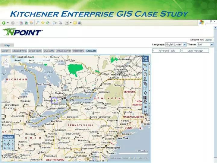
Google Earth Virtual Earth ArcIMS OGC-WFS OGC-WMS ArcGIS-Server GeoMedia WebMap MapPoint OnPoint Business Systems and Databases Map Services Asset Mgmt Oracle Tax DB2 Eco Dev SQLServer Facilities ArcFM Utilities Oracle Document and Drawing Management Systems One Window Application Photograph Repository Single Access Point for End User
Inspiration – Provide a COTS solution Security at multiple levels Support for multiple languages in a SINGLE application Enterprise Integration with Business Systems Edit (spatial and non-spatial) and collaborate All of the foregoing without writing a single line of code (absolutely no programming) with OnPoint’s Administration Tool Ease and speed of deployment Build applications on the fly (with end user sitting next to you) Modify applications as user requirements change