Download
1 / 14
150 likes | 485 Vues
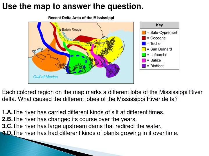
Use the map to answer the question. Each colored region on the map marks a different lobe of the Mississippi River delta. What caused the different lobes of the Mississippi River delta? A. The river has carried different kinds of silt at different times.

E N D
Use the map to answer the question. Each colored region on the map marks a different lobe of the Mississippi River delta. What caused the different lobes of the Mississippi River delta? • A.The river has carried different kinds of silt at different times. • B.The river has changed its course over the years. • C.The river has large upstream dams that redirect the water. • D.The river has had different kinds of plants growing in it over time.
Use the sketch to answer the question. • The sketch represents a map view of an imaginary river delta that formed similarly to the Mississippi Delta. From youngest to oldest, in what order did these delta lobes form? • A.W, X, Y, Z • B.W, Y, X, Z • C.Y, W, X, Z • D.Z, Y, X, W
Use the map to answer the question. • Louisiana has lost and gained land on its coast over the years. The red color on the map shows the land gained in Atchafalaya Bay between the years 1932 and 2000. What caused the new land to form? • A.sediments moved by waves • B.tectonic uplift • C.sediments carried by rivers • D.dropping sea levels
Mass movements • The downslope movement of loose sediments and weathered rock resulting from gravity • Weathering erosion mass movements • Climate controlled • All occur on slopes
Influencing variables • Material’s weight • Resistance to sliding or flowing • A trigger event (ex. Earthquake) • Erosion at the foot of a slope • water
Water and mass movements • Too little prevents sediments from holding together, increasing potential for movement • Too much water increases the weight of the soils; can also act as a lubricant • Not involved as transport agent
Types of mass movements • Classified as: • Creeps • Flows • Slides • Falls • Slumps • Avalanches
Creeps • Slow, steady downhill flow of soils • Noticeable over long periods • Observe structures to identify creeps • Solifluction occurs when layer above permafrost slides downhill
Flows • Flow as if the mass was a thick liquid • Can move fast or slow • Mudflows-swiftly moving mixtures of mud and water • Common in volcanic regions • Also common in semi-arid regions that experience intense short rainstorms (So Cal)
Slumps • When material in a landslide rotates and slides along a curved surface • Occur in areas with think soils and steep to moderate slopes • Common after rains • Leave crescent shaped scars
Avalanches • Landslides that occur in mountainous areas with snow • Usually occur on slopes of at least 35 degrees • 10000 avalanches occur every year in west US alone • Sun melts surface snow refreezes over night loose snow accumulates becomes heavy and slips off • Snow refreezes into crystals vibrations send the layer down slope
Rock Falls • Occur at high elevations, in steep road cuts, and rocky shorelines • Rock breaks and falls downward • Produces a cone shaped pile of debris called talus • Less likely to occur in humid regions
Mass movements and people • Constructing heavy buildings and roads and poor maintenance of sewer systems can result in mass movements • Venezuela 1999 experienced heavy rains which resulted in severe mudflows killing tens of thousands of people • Can be avoided by not building structures on steep slopes • Trenches can be dug to divert water