Download
1 / 40
410 likes | 582 Vues
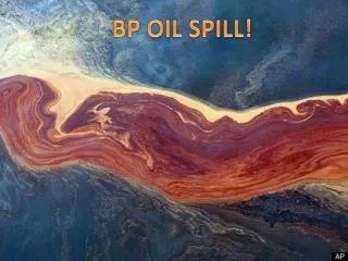
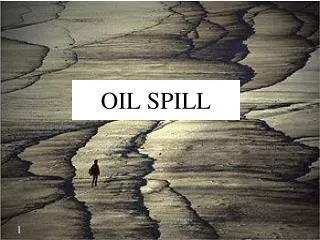
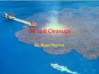
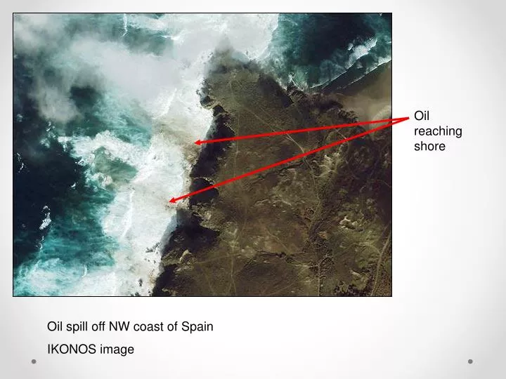
Oil reaching shore. Oil spill off NW coast of Spain IKONOS image. Radar image of oil spill off NW coast of Spain (Black areas = oil). Active Remote Sensing. Radio Detection and Ranging = Radar Light Detection and Ranging = Lidar. Passive vs . Active Remote Sensing.

E N D
Oil reaching shore Oil spill off NW coast of Spain IKONOS image
Radar image of oil spill off NW coast of Spain (Black areas = oil)
Active Remote Sensing Radio Detection and Ranging = Radar Light Detection and Ranging = Lidar
Passive vs. Active Remote Sensing • Passive remote sensing uses the energy from the sun • Active remote sensing sends out its own energy and records how much bounces back • Imaging Radar uses microwave wavelengths • Lidar uses visible wavelength (laser) or sometimes NIR
Side-looking Radar • Most radar systems do look off to the side (off-nadir) • For military applications allows planes to fly over friendly territory and look into enemy territory • More importantly, gives us more info about surface characteristics • Radar is sensitive to surface roughness
Radar Terminology • Swath width = range • Direction of flight = azimuth • Backscatter = reflectance • Angle of view = depression angle • Etc.—unique terminology
Radar Geometry Depression Angle
Radar Advantages • Can penetrate clouds • Active, so can use day or night • Less of a radiance vs. reflectance problem since you know exactly how much energy you send out and can measure what you get back—and atmosphere not a problem • Can penetrate dry soil and get subsurface characteristics (e.g., archaeology)
Radar Disadvantages • Developed by military, less civilian experience so far than passive remote sensing • Difficult to interpret—complicated causes of reflectance • Geometric distortions caused by side looking geometry
Radar bands were originally code names assigned by the military
Polarization • Electromagnetic radiation can be polarized • the plane of the traveling electric fields can be all horizontal or all vertical • Radar uses polarization information to record info about the surface • Rough surfaces tend to depolarize microwave radiation • Buried objects (subsurface inhomogeneity) can also depolarize microwaves From Wikipedia Commons
Polarization (cont) • Transmit Receive Together V H VH H V HV V V VV H H HH
Polarization (cont.) • By recording an HH image and an HV image you can measure the amount of cross-polarization (radiation that changes from horizontally to vertically polarized when it interacts with a surface) • Highlights areas on the ground that tend to depolarize radiation (e.g., rough surfaces, structurally complex materials like plants with leaves oriented various ways)
Interpretation of Radar Data • Surface “smoothness” or “roughness” with respect to radar depends on wavelength and incident angle • A smooth surface reflects in one direction (specular) • A rough surface scatters radiation in all directions (Lambertian or diffuse) • Rough surfaces tend to depolarize radiation
Surface Roughness Shorter wavelength radar can resolve roughness more finely
Type of Backscatter (Reflection) • Diffuse • Vegetation canopies • Cross polarization (use HH and HV) • Specular • Microwaves reflected away (not scattered) (e.g., oil slick) • Corner reflectors • Tree trunks and buildings • can make objects very “bright” or very “dark” depending on orientation
Surface roughness is described as a function of wavelength and the angle of incidence of the incoming radiation
Interpreting Radar Data • Longer wavelength bands (P and L bands) • Penetrate canopy and reflects off of standing tree trunks • Can detect amount of wood in a forest • Estimate forest biomass • Shorter wavelengths (C and X bands) • X band can detect leaves • C (and L) band can detect twigs
Resolving Objects with Radar • Radar resolution determined by… • Size of area “illuminated” by microwaves at one time • Depends on antenna length (longer antenna = better spatial resolution) • But…difficult physically for airplane or satellite to carry a very large antenna. • Depends on length of radar pulse (longer pulse = lower spatial resolution)
Real Aperture vs. Synthetic Aperture Radar (SAR) • Real aperture radar actually uses a single antenna of a given length – resolution limited to what plane or satellite can carry. • Synthetic Aperture Radar (SAR) can simulate a large antenna by taking advantage of the Doppler effect • Doppler shift allows sensor to identify electromagnetic waves from ahead and behind the platform and therefore track an object for longer than it otherwise could, as if the antenna were longer.
Radar Sensors • There are many imaging radar sensors available, both airborne and on satellites • Most aircraft use SAR • All satellites use SAR (to achieve reasonable spatial resolution)
Radar Applications • Forest inventory • Oceanography • Archaeology • Sea ice studies • Digital Elevation Models (DEMs) • Urban mapping • Wildfire studies
Radar Image – Angkor, Cambodia. Purple spots are possible buried ruins
Kamchatka Peninsula – Shuttle Radar Topography Mission (SRTM) (Mission generated detailed topographic data for 80% of earth’s land surface)
Lidar Remote Sensing • Like Radar but sends laser pulses instead of microwave/radio pulses • Can collect extremely accurate elevation data quickly (vs. ground survey) • Typically flown on aircraft
landslides Southern Bainbridge Island