Download
1 / 30
300 likes | 443 Vues
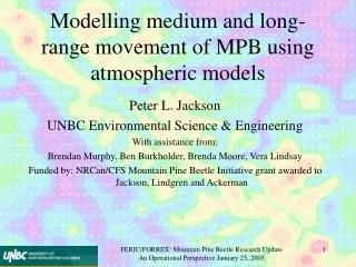
Modelling of MPB Transport and Dispersion using Atmospheric Models. Peter L. Jackson Brendan Murphy UNBC Environmental Science & Engineering With assistance from: Ben Burkholder, Melissa Darney, Brenda Moore

E N D
Modelling of MPB Transport and Dispersion using Atmospheric Models Peter L. Jackson Brendan Murphy UNBC Environmental Science & Engineering With assistance from: Ben Burkholder, Melissa Darney, Brenda Moore Funded by: NRCan/CFS Mountain Pine Beetle Initiative grant awarded to Jackson, Lindgren and Ackerman Mountain Pine Beetle Initiative Research Program Update Session April 8, 2004
Outline • Introduction / Motivation • Objectives / Outcomes • Methods • Synoptic Climatology Results Highlights • Atmospheric Modelling – Test Case (first try) • Information Needs… Mountain Pine Beetle Initiative Research Program Update Session April 8, 2004
Introduction / Motivation • MBP infestation has reached epidemic proportions in central BC affecting 4.2 million ha and 108 million m3 of timber • Emergence and flight in summer after 3 days of Tmax > 18 ºC but < 30°C Mountain Pine Beetle Initiative Research Program Update Session April 8, 2004
Dispersion is • active by flight over short distances / light wind (local scale: within stand over a few km) • passive advection due to winds and turbulence above and within canopy (landscape scale: between stands perhaps 10-100 km) • Passive transport allows epidemic to spread rapidly over great distances little is known about passive transport and this is the focus of our work Mountain Pine Beetle Initiative Research Program Update Session April 8, 2004
MPB fly on hot summer days • Warmest conditions usually occur under slack synoptic weather conditions terrain-induced thermal circulations (e.g. mountain/valley winds, anabatic/katabatic flows) and steering of winds by terrain should determine the above-canopy, and the within-canopy air flow Mountain Pine Beetle Initiative Research Program Update Session April 8, 2004
Objectives • Identify synoptic weather patterns present during periods of MPB dispersal • Identify fundamental relationships between terrain features, atmospheric flows and MPB fallout zones • Assess potential for physics-based meteorological and dispersion models to estimate MPB dispersal from one year to the next Mountain Pine Beetle Initiative Research Program Update Session April 8, 2004
Methods • The premise behind our work is that passive transport of MPB is not unlike transport and dispersion of air pollutants • Techniques exist to model air pollution • Physics-based mesoscale atmospheric models are well-developed and tested • Models have demonstrated skill representing and predicting the circulations in complex terrain that are likely important during times of MPB flight Mountain Pine Beetle Initiative Research Program Update Session April 8, 2004
Objectives 2 &3 will make use of the CSU Regional Atmospheric Modeling System (RAMS) to simulate the atmosphere (wind, temperature, humidity, pressure, etc. on a nested 3D grid) • The meteorological fields from RAMS will then drive a Lagrangian Particle Dispersion Model (HYPACT) that will advect and disperse MPB • Can also calculate forward and backward trajectories from the model wind fields Mountain Pine Beetle Initiative Research Program Update Session April 8, 2004
A basic step prior to modelling is to find the average environmental conditions present during MPB flight • The Synoptic weather pattern determines the atmospheric background conditions in which MPB emerge and move. • Average weather pattern(s) associated with MPB flight are found using compositing • This leads to an understanding of regional wind patterns Mountain Pine Beetle Initiative Research Program Update Session April 8, 2004
Synoptic Climatology • As a surrogate for known dates of MPB flight, we have defined “Heating Cycle 1” (HC1) as at least 4 consecutive days with the Tmax > 20 oC but < 30 oC • We use the weather pattern on day 3 to define the composite • We have identified 3 related map types corresponding to HC1 defining the general weather patterns during emergence and flight Mountain Pine Beetle Initiative Research Program Update Session April 8, 2004
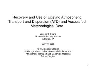
Distribution of HC1 by month for Prince George 1943-2002 (8.9 cycles/y) Heating cycle length Avg length = 5.6 days Max length = 24 days (1979) Mountain Pine Beetle Initiative Research Program Update Session April 8, 2004
Distribution of wind speed by hour at Prince George during HC1 Distribution of temperature by hour during HC1 Mountain Pine Beetle Initiative Research Program Update Session April 8, 2004
Peak Emergence • It is likely that passive transport will be most important when peak emergence is occuring • Peak emergence is associated with higher temperatures • Define HC2 as days with Tmax > 25 C, but < 30 C Mountain Pine Beetle Initiative Research Program Update Session April 8, 2004
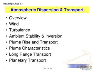
500 hPa July & August climate (all days), HC2 composite, anomaly Sea level July & August climate (all days), HC2 composite, anomaly Mountain Pine Beetle Initiative Research Program Update Session April 8, 2004
July & August Climatology, HC2 composite and anomaly for Temperature at surface, and Relative Humidity at 700 hPa (clouds). Mountain Pine Beetle Initiative Research Program Update Session April 8, 2004
Evolution of 500 hPa composite pattern through HC2 event • as upper ridge passes atmosphere becomes moderately unstable • this would result in increased afternoon “thermals” Mountain Pine Beetle Initiative Research Program Update Session April 8, 2004
Evolution of surface composite pattern through HC2 event • sea level pressure drops as temperature increases • pressure drop seems to be consistent across many cases – does MPB emergence and flight respond to pressure as well as temperature? Mountain Pine Beetle Initiative Research Program Update Session April 8, 2004
Validation of HC2 / Peak Emergence • common features of peak emergence: • as surface temperatures go up • sea level pressure drops • pattern seen in several other cases too…(we need more emergence data at daily resolution) Mountain Pine Beetle Initiative Research Program Update Session April 8, 2004
(mslp – white 500 hPa – yellow) Andrew McLellan /CANFOR; Bugbusters, Mountain Pine Beetle Initiative Research Program Update Session April 8, 2004
Atmospheric Modelling – Test Case (first try) • RAMS run for July 28 -Aug 1 2003 • 5 nested grids at 81,27,9,3,1 km horizontal resolution • 30 levels in vertical starting at 25 m resolution Mountain Pine Beetle Initiative Research Program Update Session April 8, 2004
2003 MPB destinations 2003 MPB source Mountain Pine Beetle Initiative Research Program Update Session April 8, 2004
Time-height cross section from a location west of the Rockies. Wind (arrows), temperature (contours) and potential temperature (colour) Mountain Pine Beetle Initiative Research Program Update Session April 8, 2004
Chetwynd Burnt R. MacKenzie North of Monkman Park Hourly output from RAMS simulation at model level 2 (~40 m AGL), from grid 4 at 3 km horizontal resolution (only every 2nd wind vector shown) Mountain Pine Beetle Initiative Research Program Update Session April 8, 2004
Trajectories • Three scenarios chosen: • Two “endpoints” – 2003 green attack east of Rockies • One “starting point” 2003 red on western slope of Rockies • Foreword Trajectories in RED starting at 11:00 PDT at 1 hour resolution • Backward Trajectories in BLACK from 2003 green attack starting at 16:00 PDT at 1 hour resolution • (there are some problems with the wind simulation that we are working on– so these are far from final results) Mountain Pine Beetle Initiative Research Program Update Session April 8, 2004
2003 MPB destinations 2003 MPB source Mountain Pine Beetle Initiative Research Program Update Session April 8, 2004
40 m 105 m Mountain Pine Beetle Initiative Research Program Update Session April 8, 2004 309 m 1288 m
40 m 105 m Mountain Pine Beetle Initiative Research Program Update Session April 8, 2004 309 m 1288 m
Kwoen – MWLAP weather station in Burnt River – east of Rockies • wind speeds OK • wind directions are poor • we are looking at why… • MacKenzie – EC weather station • wind directions west of Rockies slightly better Mountain Pine Beetle Initiative Research Program Update Session April 8, 2004
Information Needs • More documented MPB flight / emergence periods, ideally at daily resolution • MPB time in flight, height of flight – how many fly above the canopy? – working with new MSC doppler radar at Baldy Hughes – pilots? • More “case studies” of between stand movement for validation (especially isolated populations) – Prince George City Mountain Pine Beetle Initiative Research Program Update Session April 8, 2004
The End Mountain Pine Beetle Initiative Research Program Update Session April 8, 2004