Download
1 / 19
200 likes | 426 Vues
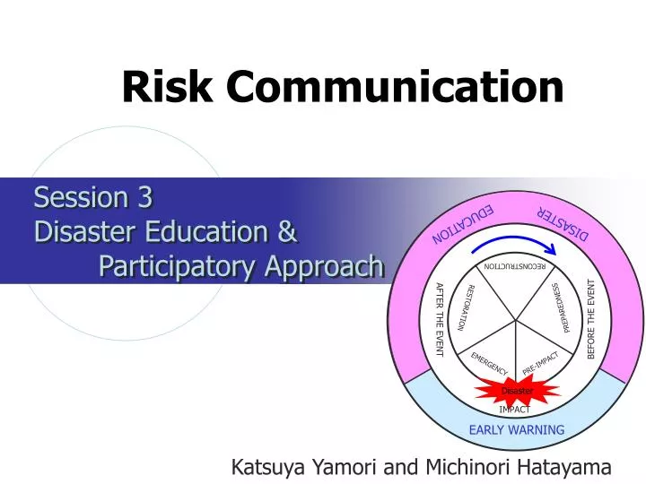
Risk Communication. Session 3 Disaster Education & Participatory Approach. DISASTER. EDUCATION. RECONSTRUCTION. PREPAREDNESS. RESTORATION. BEFORE THE EVENT. AFTER THE EVENT. PRE-IMPACT. EMERGENCY. Disaster. IMPACT. EARLY WARNING. Katsuya Yamori and Michinori Hatayama. Contents .

E N D
Risk Communication Session 3 Disaster Education & Participatory Approach DISASTER EDUCATION RECONSTRUCTION PREPAREDNESS RESTORATION BEFORE THE EVENT AFTER THE EVENT PRE-IMPACT EMERGENCY Disaster IMPACT EARLY WARNING Katsuya Yamori and Michinori Hatayama
Contents 1. Important approaches to disaster education 2. “Active risk” vs. “Neutral risk”:Background of participatory approach to disaster education 3. Basic forms of disaster education 4. Some practical methods and procedures in disaster education and learning
Important approaches to disaster education • One-way / Participatory (Collaborative) • Knowledge / Skill • Desktop / Field • School / Adult (Life-time) • Specific / Comprehensive
“Active (Perceived) risk” • The importance of participatory and collaborative disaster education is explained with respect to risk. • “(Perceived) Risk”: an active attitude towards natural hazards • “Danger” often represents a neutral mind-set concerning hazards • “Risk”: from Italian word “risicare,” which means, “dare to do something.” • The active (perceived) aspect of human beings with respect to danger is an essential part of the meaning of risk
Table 1 Statistical representations of average risk level of various hazards How many people killed for the 100 thousand population? Car accident (3.1) Murder (0.41) Thunder (0.005) Typhoon (0.01)
“Neutral (Actual) Risk” • In table 1, “risk” is interpreted to be almost identical to “danger.” • Objective assessment based on statistical data about hazards considers risks as the ones existing independently of those who receive the data . • No active position to change the statistics, but just to receive the data neutrally as given and accepted as facts. Thus • “Neutral or actual risk”
Both neutral risk communication and active risk communication are needed Neutral risk assessment Active risk taking
Basic forms of disaster education • At elementary schools: Evacuation drills for an earthquake (Fig. 1) • At local communities: Rediscovering what exactly happened in the past (Fig.2) • From mass media: Identifying useful hints about disasters from TV programs (Japan) (Philippine ) Fig.1 Go under the desk during an earthquake Fig.2 A display indicating the height that the last Tsunami reached in a local town in Japan
Some useful methods for disaster education and learning • Workshop • Gaming • Integrated disaster reduction drill • Town walking
Workshop: Disaster Imagination Game (DIG ) • To involve stakeholders such as local residents, local government officials, disaster relief volunteers, and also disaster experts • To co-produce a “DIG map” of their local community • To discuss such issues as what kind of responses are needed for an emergency, how different sectors can cooperate with each other, and what preventative measures can be taken in advance in the community
Integrated disaster reduction drill • A wide variety of participants • School children • Parents • Teachers • Local residents • University professors • Local government officials • A wide variety of contents • Disaster map drawing • Fire extinguisher drill • Simulated earthquake shaking experience • Emergency food cooking • Furniture fixing device set-up training • Emergency toilet set-up training • The next slide shows some snapshots from such a drill conducted at an elementary school in Aichi Prefecture
Integrated disaster reduction drill Fire extinguisher drill Emergency toilet set-up training Furniture fixing device set-up training Disaster map drawing
CrossRoad KOBE Game (1) Example: Suppose you are a member of the local government staff. Your house was seriously damaged by a severe earthquake this morning and your wife and two kids were wounded. Although you are all safe, your family looks very nervous. Your mission is to make relief materials available to disaster victims in the regional disaster prevention plan. Are you going to your office right away, or to stay at home to take care of your family? • A group game • A series of forced-choices between “Yes or No” such as the example shown in the box. • A tough decision which people might face when they prepare for or respond to disasters. • Personal decisions by individual participants, guessing the decisions with each other, and explaining the grounds for individual decisions
CrossRoad KOBE Game (2) • Careful and serious consideration is required taking into account the costs/ benefits of the two choices • If asked to, explain reasonable grounds for the decision • Identify good practices for active risk taking • Work out an appropriate solution depending on a specific situation • Become aware of how differently people could react to the same dilemmatic condition
Town walking program(Outdoor workshop) • Disasterprevention usually done in an explicit way. • Difficult for local community to maintain concern during daily life. • Disaster prevention that does not explicitly talk about preventing disasters.
Town walking program Methodology • NGOs, local volunteer groups, community people (including children) walk and observe the town. • The workshop is less about "Disaster Prevention" explicitly, but more about daily living concerns. • Usually children can lead the workshop. They become interested in hazardous spots, disaster prevention devices, such as fire plugs, evacuation facilities, etc., along with other important elements in their own town.
Community Safety Information Map The purpose of making community safety maps • To summarize local information collected in disaster education and learning activities • To continuously update local information based on repeated disaster education and mutual learning activities, and lessons learned • To promote participatory map making Well Primary School Settlement Area Example (one of the areas in Bangladesh)
The Community Safety Information Map Making Process (1)Start town watching (3)Take pictures (5)Collect information on map Community Safety Map (2)Find useful/dangerous spot (4)Mark the spot on map Contents of Community Safety Information Map Disasters prevention organization information Municipal Office / Police Station / Firehouse and Fire brigade station… Refuge Place / Refuge Direction and Route / Dangerous spot for Refuge… Refuge information Medical institution information Disaster emergency information Fire Hydrant / Temporal Heliport / Rescue Materials Warehouse…. Hospital / Clinic / Drugstore, … Lifeline management organization information Water and Sewerage Office / Phone Company / Electricity Company…. Others Pool / water tank / well … Disaster-vulnerable people information Kinder garden / Elementary School / Welfare Spot…
Flood Earthquake Hazard Map http://www.pref.osaka.jp/kikikanri/crisis/plan/research/research.html#TOP http://www.city.bunkyo.tokyo.jp/service/disaster_prevention/suigai/hazard.pdf By overlaying hazard maps on the community safety map you can develop a better safety map for your town. If you add a lot of information to community safety maps, a GIS( Geographic Information System) is useful as an advanced computer system.