Download
1 / 16
160 likes | 356 Vues
With A bright 3.5 inch sunlight-readable LCD display, this new stand-alone device can easily installed in your panel, and connected to the aircraft pitot and static systems, and the included GPS.

E N D
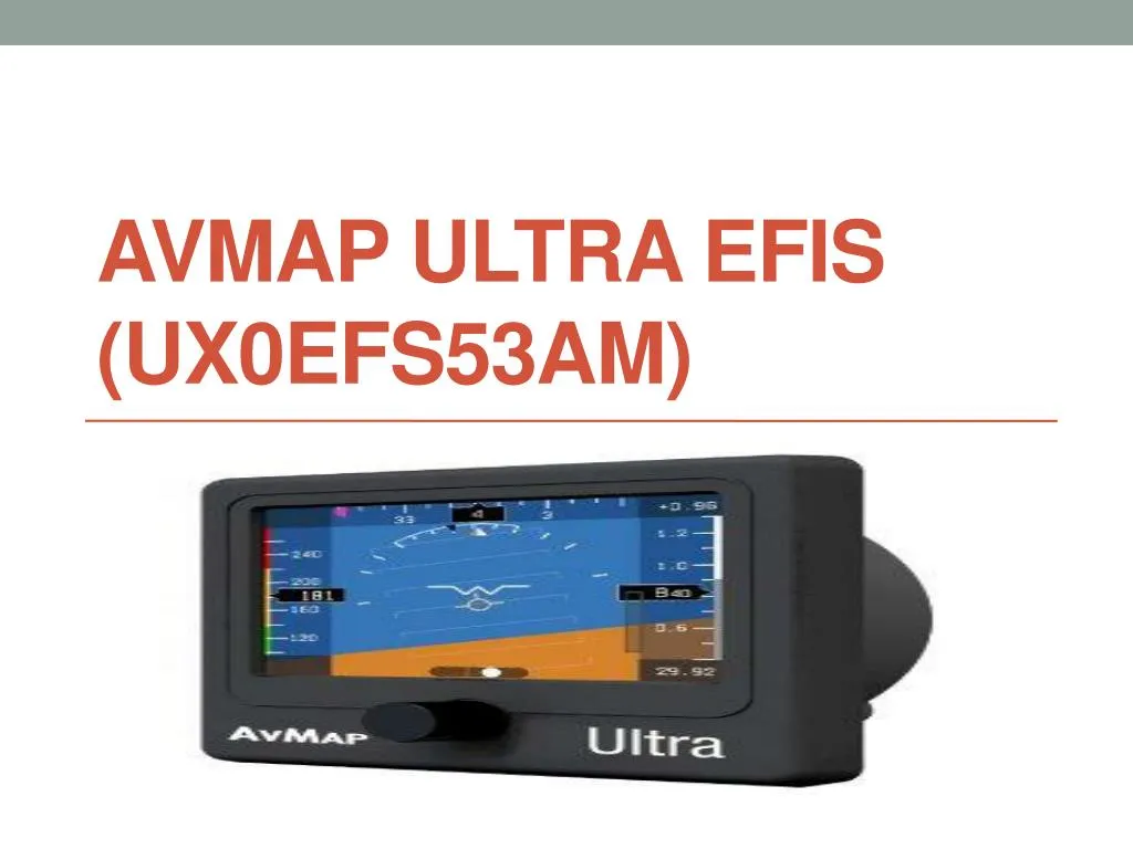
**NEW VERSION** Avmap ULTRA EFIS. With A bright 3.5 inch sunlight-readable LCD display, this new stand-alone device can easily installed in your panel, and connected to the aircraft pitot and static systems, and the included GPS.
Compact, light and easy to install, providing reliable and advanced ADAHRS and provides:• Attitude (Roll, Pitch and Heading)• Airspeed • Altitude
• Vertical Speed• Wind Indicator• Sideslip Indicator• HSI with Course Deviation Indicator
The Ultra EFIS is lightweight, at only 230g , requires less than 3 inches of panel depth, and is installed in an 80mm (3 ⅛ inch) panel hole.
Designed for light-sport, ultra light and experimental aircraft, the AvMap Ultra EFIS contains solid-state gyros, accelerometers, magnetic field sensors, air data sensors and UAV Navigation motion processor
Technical specifications: • Dimensions: 95 x 95 x 63.3 mm (3.74” x 3.74” x 2.49”)• Diameter: 77.5 mm (3.05”); Installing diameter: 79.5 mm (3.125”)• Weight: 230 g (8.1 oz)
• Display: 3.5”; 320 x 240 pixels, brightness 500 cd/m2• Operational Temperature: -20 °C to + 70 °C / -4 °F to +158 °F• 3-axis gyros, accelerometers and magnetometers• Acceleration range (3 axis): +/- 8 g
• Rotation Range: +/- 1600 deg/s• Air data sensors: range 10 to 215 kts, -1000 to 40000 ft• UAV Navigation® Motion processor• Micro SD slot (for data logging)
• 1.5 m (59”) free wires power supply cable (10/35 VDC)• 3 serial ports RS-232• Consumption @ 12 V DC: 100 mA nominal
Included accessories: • GPS receiver U-Blox NEO 6Q with 1.5 m (59”) cable• Blank MicroSD Card• Mounting KIT (Cutting template, 4x metal washers and 4x screws)• 1x 1A fuse holder• Microfiber cleaner cloth
Software Capabilities: • Advanced data fusion capability• Airspeed and Altitude from pitot-static system• Attitude (roll, pitch and heading) and side slip• Wind indicator
• Clear HSI with Course Deviation Indicator (CDI)• Altimeter reference, Heading reference, Aircraft specific V-speed reference values• Preloaded with Jeppesen Database (APT, VOR, NDB) for navigation back-up
• Exceptional navigation capability in case of loss of GPS signal• Load factor (G-meter)
For more information, visit us http://www.ozpilot.com.au/