Download

1 / 1
10 likes | 102 Vues
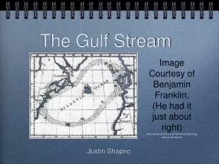
Packing Heat in the Gulf. (G. Goni and J. Trinanes, NOAA/AOML).

E N D
Packing Heat in the Gulf (G. Goni and J. Trinanes, NOAA/AOML) Tropical Cyclone Heat Potential (TCHP) fields are derived from altimetry data for hurricanes Katrina (left) and Rita (right) in 2005. The path of each hurricane is indicated with circles, their size and color representing intensity (see legend), as the storms made their way across the Gulf of Mexico. Both hurricanes rapidly intensified to category 5 as they passed over the Loop Current and a warm ring, then diminished to category 4 and category 3, respectively, by the time they traveled over cooler waters outside the warm ring. NOAA’s Atlantic Oceanographic and Meteorological Laboratory uses blended satellite altimetry data, including those from NASA's TOPEX/Poseidon and Jason-1 missions, to estimate TCHP (a measure of the oceanic heat content from the sea surface to the depth of the 26°C isotherm) in the Gulf of Mexico in near-real time. High values of TCHP may be linked to hurricane intensification. These fields are critical to scientists and forecasters in better understanding the link between the ocean and the intensification of hurricanes. See http://www.aoml.noaa.gov/phod/cyclone/data/ for more information.