Download

1 / 15
150 likes | 234 Vues
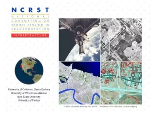
What is NCRST. Funded under TEA-21, 1998 US DOT: Research & Special Programs Administration Philosophy: rapid evolution of research into commercial products, practice User consultation and outreach Partnerships: industry, international. The NCRSTs. Environment — Mississippi State

E N D
What is NCRST • Funded under TEA-21, 1998 • US DOT: Research & Special Programs Administration • Philosophy: rapid evolution of research into commercial products, practice • User consultation and outreach • Partnerships: industry, international
The NCRSTs • Environment — Mississippi State • Chuck O’Hara • Infrastructure — UC Santa Barbara • Raad Saleh (Wisconsin) • Flows — Ohio State • Charles Toth • Disasters — New Mexico • Demin Xiong (Oak Ridge) • 9 Technology Application Partners • Chris Chiesa (Veridian)
NCRST Interest in Centerlines • 3 of 4 consortia have centerline extraction projects • 2 of 9 TAPs are focused on centerline extraction
UCSB Interest in Centerlines • 1970-90 Tobler, Church, Goodchild, etc • Funded by Caltrans, USDOT-FHWA since early 1990s: towards IVHS/ITS models • Modeling of geometric error • GPS, wireless communication • Map rectification • NCRST: remote sensing • ESRI: essential data model for transportation
Why CLEM2001? • Centerlines widely studied • Diverse approaches, each successful in particular domain • To become common practice: • understand niche of each method • faster, cheaper, more accurate • rural vs urban areas • exposed vs canopy, etc • consolidate techniques
Some Centerline Applications • Precision snow plowing ± 0.2 m • ITS messaging … mayday ± 0.1-20 m • Toll by road/lane use ± 2 m • Highway asset management ± 15 m • Elections: right topology • Market research: who uses BrandX toothpaste: ± 500 m
Some Criteria • Cost • Timeliness • Errant counties fail to report • Disaster response • Accuracy • Scope • Neighborhood vs city vs global
Easy Street • New neighborhood • Little or no foliage overhang • Vehicles in garage/driveway
Not so easy • Repairs and surface coats • Paint stripes • Shadows • Parked vehicles • Foliage overhangs
Conclusion • One solution is not necessarily better than the others across all criteria — each has its niche • CLEM2001 is an opportunity to learn from each other
Agenda Structure — Monday • View from the data producers • Don Cooke, GDT — accuracy • Bob LaMacchia, Census — beyond TIGER • Introductory survey of techniques • Raad Saleh
Agenda Structure — Monday • Image analysis techniques • Ed Granzow, Iguana • Demin Xiong, Oak Ridge • Dar Roberts, UCSB • Chris Funk, UCSB • Chris Chiesa, Veridian • Peter Gipps, Quantm
Agenda Structure — Tuesday • GPS/ITS techniques • Christopher Bennett, Montgomery Watson • Charles Toth, Ohio State • Russ Shields, Ygomi • GPS/Photogrammetry demo • Ted Jones/Gay Hamilton Smith, Florida DOT/HSA Consulting
Agenda Structure — Tuesday • Data modeling • Kai Han, U/Manitoba • Terry Bills, GIS/Trans • Kevin Curtin, UCSB • What have we learned, where next (CLEM200x)? • Mike Goodchild, UCSB