Download
1 / 15
150 likes | 245 Vues
An Inventory of Native American Effigy Mounds on the Rock River Trail (North to south). By Frank Schier Rock River Trail founder.

E N D
An Inventory of Native American Effigy Mounds on the Rock River Trail (North to south) By Frank Schier Rock River Trail founder
According to Indian Mounds of Wisconsin, by Birmingham and Eisenberg, when settlers arrived in Wisconsin, 15,000 to 20,000 mounds populated the state, today approximately 4,000 remain. These are protected by the 1985 Wisconsin Burial Site Preservation Law.
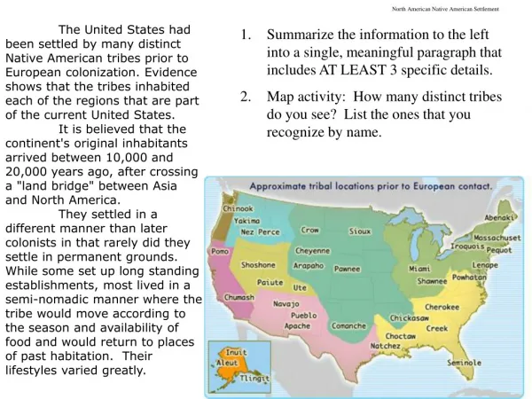
WisconsinFOND DU LAC COUNTY • Lake Winnebago – • High Cliff State Park, Sherwood, Wis. • Fond du Lac? • Brownsville? • Waupun?
WisconsinDODGE COUNTY • HoriconHoricon Marsh, DNR gives Spring and Fall Tours. Was inhabited by Paleo-Indians, Hopewellian people and Mound Builders since the last Ice Age. Effigy Mounds were built by the Mound Builders. http://rockriverarch.blogspot.com/
WisconsinDODGE COUNTY • NitschkeMounds Park contains Effigy Mounds: Panther, Turtle, Canine (Wolf or Fox), Tadpole or Gourd, Buffalo or Bear, and Flying Goose. Largest is the Turtle Effigy that measures 200 ft. long, 57 ft. wide and 4 ft. high. Buffalo effigies, also found around Horicon Marsh, are rocks naturally shaped like a buffalo. Some of the rocks have been changed only slightly by Native Americans and may date back to over 5,000 years. • Hustisford? • Lake Sinissippi? • Watertown?
WisconsinJEFFERSON COUNTY • Milford • Aztalan State Park Pyramids – Wisconsin's most important archaeological site. It showcases an ancient Middle-Mississippian village that thrived between A.D. 1,000 and 1,200. Some of the ancient mounds and stockade have been restored. Archaeologists say the inhabitants had cultural traditions in common with the Cahokia, a large Middle-Mississippian settlement near East St. Louis. Ill. They built large, flat-topped pyramidal mounds and a stockade around their village They hunted, fished, and farmed on the floodplain of the Crawfish River. Portions of the stockade and two mounds have been reconstructed in the park. There are three platform mounds on the site, the largest in the southwest corner of the stockade; one almost as large is located in the northwest corner. The smallest of the three is along the east side of the settlement, near the Crawfish River. The hill in the southeast corner is a natural gravel knoll, not built by the inhabitants. Beginning in the1920s, the site was extensively excavated, and two of the four platform mounds as well as segments of the wall have been reconstructed. To the northeast of Aztalan is a line of large conical mounds that mark the locations of ceremonial posts as well as the burial of a young woman who was probably one of the Mississippian elite. A brochure for a self-guided walking tour is available at the site and at the headquarters of the Department of Natural Resources.
WisconsinJEFFERSON COUNTY • The Aztalan Museum, operated by the Lake Mills-Aztalan Historical Society, Inc., is just north of the park. The Historical Society sponsors a festival on the museum grounds each year. • Jefferson? • Fort Atkinson – Panther Intaglio. Discovered in 1850, it is the only known intaglio Effigy Mound in the wold, excavated for ceremonial purposes by American Indians of the Effigy Mound Culture about 1,000 A.D. • Lake KoshkonongIndian Mounds Park • Altpeter Park is in the North Shore area of Lake Koshkonong. • *(Crossing Dam at Indian Ford, a former fording site for Native Americans.)
WisconsinDANE COUNTY • Madison- Thunderbirds! • Madison – Elmside Park Mounds entered into the National Registry of Historic Places, April10, 1991 (Multiple Late Woodland Stage in Archaeological Region 9 MPS) • Madison – Vilas Circle Bear Effigy Mound and the Curtis Mounds entered into the National Registry of Historic Places, Dec. 30, 1974 • Baum Mound Group, Goodland County Park, Dunn The Baum Mound Group consists of three linear mounds and one conical mound. They are located along both sides of the main park road from the park sign to Lake Waubesa. • Burrows Park, off Sherman Avenue, Madison Burrows Park, a small park on the shore of Lake Mendota, contains a reconstructed bird effigy mound with a wingspan of 128 feet. A second effigy, a fox or canine-like animal, was destroyed. The bird was damaged early by looting, but was restored by workers for the Works Progress Administration under the direction of Charles E. Brown. Charles E. Brown Indian Mounds were entered into the National Registry of Historic Places, Jan. 5, 1984 • Middleton? • Lake Kegonsa – This region contains a total of 26 Indian mound groups, including several of rare effigy species, scattered over an area of 20 square miles, according to a 10-year survey by Dr. W. G. McLachlan of McFarland. Some of the land has been compromised by cultivation practices, gradually encroaching on the lowly monuments of the Indian mounds. The lake was known by the Winenbagos as Na-sa-koo-cha-tel-a, or “hard maple grove” lake. This was derived from the presence of the sugar bush on Sugar Bush point, the site of an early Winnebago village. “Kegonsa,” an Algonkian Indian name given to the lake by Dr. Lyman G. Draper circa1855, is said to be a corrupt form of “GigoAgassinad,” or “small fish.” • McFarland – Has a plan to restore the mounds in Indian Mound Park, about 10 miles south of Madison. The mounds have been obscured by years of vegetation growth and inconsistent maintenance, while unofficial trails have come too close, and in some cases, crisscrossed the historic sites. Now, the McFarland School District, village and state officials hope to remove trees and reroute trails in an effort to restore the mounds closer to their original status. The mounds, which sit on village-owned land, became part of the district's school forest in 2008. Since then, a long-term preservation plan has been developed. • Stoughton? • Albion? • Edgerton?
WisconsinROCK COUNTY • Janesville? • Beloit Turtle Creek, Mouth of Turtle Creek – no documented Native American mounds. • Beloit College stands on the grounds of an ancient Native American civilization of the Mound Builders. The mounds on Beloit's campus have been part of the Rock River Valley landscape for at least 1,500 years. Beloit's mound group once contained 27 mounds in three main shapes: 19 were circular or oval, six were linear and two were effigy mounds. Which group built these particular mounds is open to question. The Ho-Chunk (Winnebago) elders say that their ancestors built them. Some researchers have questioned this claim, but the issue is not settled. Wisconsin mounds may reflect beliefs and traditions of the Ho-Chunk and other tribes, but most mounds are 1,000 to 2,000 years old. Interest in the Beloit College mounds began as early as the founding of the college itself. The mid-19th century was a time of extensive mound mapping and excavation. Much mapping was done carefully, by trained surveyors. Prof. Stephen P. Lathrop's 1852 survey of the College mounds was printed in Increase A. Lapham'sAntiquities of Wisconsin, one of the Smithsonian Institution's earliest books.
IllinoisWinnebago COUNTY • Rockton - Winnebago County: Macktown Forest Preserve Town was started in 1829 by Stephen Mack, Jr., who married Hononegah, a Winnebago woman, and they began one of the first trading posts in the county. The town was first known as Pecatonic. Each year, there is an annual historical re- enactment known as “The Gathering.” • Rockford - Rockford Country Club. No documented mounds. • Rockford - Beattie Park, N. Main St. and Park Ave. “Honor the Mounds Ceremony” Every 2nd weekend in August Beattie Park Mound Group, downtown Rockford, consists of three conical mounds (one outside the park boundaries), an effigy mound in the shape of a turtle, and a linear mound. On its west, the park is bounded by North Main Street and to its east lies the Rock River. The mounds and mound remnants in Beattie Park date from an era during the Late Woodland known as the Effigy Mound Period (circa 300-1100 A.D.) and influenced the Upper Mississippi River Valley in Iowa, Illinois, Wisconsin and Minnesota. The Beattie Park mounds probably date from about 700-1100, when most of the effigy mounds were built. The grouping represents the remnants of an area of nine conical mounds, a linear mound, an earthen embankment and two effigy mounds, a bird and a turtle. Through the years, some of the mounds were destroyed or disturbed. When the Rockford Art Museum constructed a parking lot on North Main Street in the mid-1950s, one of the conical mounds was destroyed. A ruined bird effigy was destroyed while the North Main Manor apartment building was under construction across Park Avenue from the mounds. • Rockford's Tinker Swiss Cottage & Museum– The Museum campus contains one dome burial mound. • *(Crossing,”Rock-ford a former fording site for Native Americans and early settlers.) • Rockford 15th Avenue and South Main St.-One moundat Thatcher Blake Condos, 2400 block South Main. • Rockford Airport, Village of Kishwauskiaat the mouth of KishwaukeeRiver • Undisclosed Village and Multiple Mound Site, just south of Rockford, west side of river, unprotected.
IllinoisOGLE COUNTY • Oregon,One conical mound on the corner of 3rd & Illinois in a private yard. 408 N. 3rd. • The mounds on the bluff have nearly all been opened within the last two or three years by three archaeologists. Most of these mounds contain clay-lined pits with buried bones. Mounds in the Rock River Valley are mostly small, hardly more than 10 or 12 ft. in diameter, and 2 ft. high The plain where the city of Oregon now stands is one of the “terraces” alluded to by Prof. Woodman. The mounds in this locality were generally small, and several can still be seen within the city limits. One which was opened up by street grading near the river bank of the terrace was a sort of rude tomb containing a few bones. About two miles southeast of Oregon, on the high bluffs on the east side of Rock River, a short distance below the railroad bridge “Chimney Rock,” there is a group of mounds arranged in the form of a semicircle. They are all small, and nearly all were opened many years ago, when copper implements and utensils were found. It is said that when the region was first settled, this mound was excavated and walled and covered with trunks of trees, but this was not the work of the original mound builders. • Undisclosed Multiple Mound Site, south of Oregon, east side of river, unprotected • Grand DeTour Potawatomi Indian Village. Was site of NIU archeological dig.
IllinoisLEE COUNTY • Dixon ?
IllinoisWHITESIDE COUNTY • Sterling Lawrence Park and Sinnissippi Park W. C. Holbrook investigated the Sinnissippi Mounds in 1877 and found a large mound, one of several in a row parallel with the river. This mound contained a Dolmen built of flat pieces of fossiliferous limestone. Skeletons and bones inside. Another mound contained an altar of burned rock, oval in shape, 6 ft. in diameter, 4-1/2 ft. wide, made of fossiliferous limestone. Human remains and pottery fragments found around the site, also implements made from antlers. Sterling mounds contained stone scrapers as well. At Sterling is a work thought to be a fortress. The two embankments are parallel, both north and south ones with two gateways each. Construction indicates knowledge of the cardinal points of the compass.
IllinoisHENRY COUNTY • Prophetstown State Park?
IllinoisROCK ISLAND COUNTY • Moline Black Hawk State Park – Referred to Albany. Albany Indian Mounds State Historic Site at South Cherry St. & 12th Ave. This 200-acre site features prehistoric Indian mounds, native prairie, walking and snow skiing paths, picnic shelter& restrooms. Interpretive brochures are on site, and the property is traversed by the Great River Bicycle Trail. Open daily year-round. Free.