Download

1 / 5
60 likes | 658 Vues
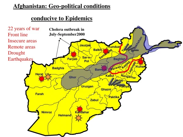
Afghanistan: Geo-political conditions conducive to Epidemics. 22 years of war Front line Insecure areas Remote areas Drought Earthquakes. Cholera outbreak in July-September2000. Badakhshan. Jauzjan. Kunduz. Takhar. Balkh. Samangan. Sar-e- Pol. Faryab. Baghlan. Kapisa. Kunar.

E N D
Afghanistan: Geo-political conditions conducive to Epidemics 22 years of war Front line Insecure areas Remote areas Drought Earthquakes Cholera outbreak in July-September2000 Badakhshan Jauzjan Kunduz Takhar Balkh Samangan Sar-e- Pol Faryab Baghlan Kapisa Kunar Laghman Parwan Badghis Bamyan Herat Kabul Nangarhar Ghor Logar Uruzgan Paktya Ghazni Farah Paktika Zabul Nimroz Kandahar Helmand
Measles Outbreaks 1998-99 1-3/2000 Districts without EPI fixed centers
Afghanistan: current urgent problems Internally displaced populations Cholera outbreaks Badakhshan Jauzjan Kunduz Takhar Balkh Samangan Sar-e- Pol Faryab Baghlan Kapisa Kunar Laghman Parwan Badghis Bamyan Herat Kabul Nangarhar Ghor Logar Uruzgan Paktya Ghazni Farah Paktika Zabul Risk for measles outbreaks, ARI and further spread of cholera! Nimroz Kandahar Helmand
Afghanistan: estimated populations Mazar-I-Sharif has a population of 1,000,000 (half of them are IDPs). Northen Region area(km2) census 97 1996 estimates Herat 38798.8 769 111 967'270 Badghis 21677.8 233 613 334'063 Badakhshan 40885.8 497 758 711'306 Takhar 12325.3 519 752 746'089 Baghlan 17164.7 493 882 706'256 Badakhshan Jauzjan Kunduz Takhar Balkh Samangan Sar-e- Pol Faryab Baghlan Kapisa Kunar Laghman Parwan Badghis Bamyan Herat Kabul Nangarhar Ghor Logar Uruzgan Paktya Ghazni Farah Paktika Zabul Nimroz Kandahar Helmand Source: The 1997 population figures are taken from the UNFPA database. The 1996 estimates are informal estimates
WHO structure and functions in Afghanistan WHO has 9 suboffices inside Afghanistan a nd a support office in Islamabad: 1. office in Jalalabad 32 staff 2. Suboffice in Kabul 12 staff 3. Suboffice in Faizabad 8 staff 4: Suboffice in Kundoz 6 staff 5. Suboffice in Ghazni 6 staff 6. Suboffice in Mazar 7 staff 7. Suboffice in Bamyan 5 staff 8. Suboffice in Herat 9 staff 9. Suboffice in Kandahar 7 staff 10. Support office in Islamabad 27 staff Badakhshan Jauzjan Kunduz Takhar Balkh Samangan Sar-e- Pol Faryab Baghlan Kapisa Kunar Laghman Parwan Badghis Bamyan Herat Kabul Nangarhar Ghor Logar Uruzgan Paktya Ghazni Farah Paktika Zabul • The total number of staff is about 119 • both in and outside Afghanistan. • The WHO suboffices: • provide technical assistance to the local health authorities • MCH, immunization, training, etc..) • serve as epidemiological surveillance stations • supervise and manage WHO projects in their regions. • monitor drug distribution to basic services and hospitals. • represent WHO in all field-based coordination activities • with UN agencies and NGOs • All suboffices regularly report to WR-Afghanistan office. Nimroz Kandahar Helmand