Download
1 / 21
220 likes | 365 Vues
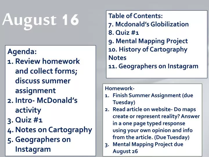
August 16. Table of Contents: 7. Mcdonald’s Globilization 8. Quiz #1 9. Mental Mapping Project 10. History of Cartography Notes 11. Geographers on Instagram. Agenda: Review homework and collect forms; discuss summer assignment Intro- McDonald’s activity Quiz #1 Notes on Cartography

E N D
August 16 Table of Contents: 7. Mcdonald’sGlobilization 8. Quiz #1 9. Mental Mapping Project 10. History of Cartography Notes 11. Geographers on Instagram Agenda: Review homework and collect forms; discuss summer assignment Intro- McDonald’s activity Quiz #1 Notes on Cartography Geographers on Instagram Homework- Finish Summer Assignment (due Tuesday) Read article on website- Do maps create or represent reality? Answer in a one page typed response using your own opinion and info from the article. (Due Tuesday) Mental Mapping Project due August 26
Map the School Reflection • How difficult was this experiment? • Did you feel you and your partner worked well together? Why or why not? • What is one scenario where you think your large scale map would be used? • What is one scenario where you think your small scale map would be used?
1 5 6 2 3 7 4 8
Which type of scale? 1 3 2
Which scale is larger? 4 or 5 or
Which line is this? 8 10. What are the four intermediate directions? 9
Homework Check 11. What is the answer to question #1 on your homework? 12. What is the answer to question #5 on your homework? 13. What is your answer to question #15 on your homework?
Geography • Study of location of people across Earth and activities across Earth and the reasons they are there • “study of the Earth” • 2 types- • Physical- natural features and landforms • Human- where and why human activities take place
Main areas of human geography: • Population • Migration • Culture (language, religion, food, art, etc.) • Politics • Development • Agriculture • Industry • Urbanization
Identify the areas of human geography shown in this film clip!
History of Mapmaking • Cartography- mapmaking • Purpose of maps- • 1. reference tool • 2. communications tool
Emmett’s map of Disney World(okay- it still needs labels to be a TRUE map, but he can’t write!) • This image, drawn by a 4 year old stores both reference material and geographic information. If he could spell, and there were labels, it would be more convincing! • Black = scary ride (Pirates, Peter Pan) • Green= good ride (Tree House, Buzz Lightyear is the largest one, his favorite!) • Trust me, when he drew the rides they were in the right order!
Ga-Sur 2500 B.C. • This is the oldest know map, drawn on a clay tablet in Ancient Babylon. • The line drawing is a clearer image of the map, which explains the position of the town on a river, in a valley.
Early mapmaking: • 600-500 BC- Miletus, a city in modern Turkey- center of mapmaking Some Early Greeks: • Thales- used geometry to measure land • Anaximander- world map made cylinder • Hecateus- first geography book
Aristotle- 1st to demonstrate that the Earth was a sphere • Erastosthenes- 1st to use word “geography”; calculated circumference of the Earth and came up with early map of climates • Ptolemy- created the Guide to Geography that listed basic principles of mapmaking. We used his maps for 1000+ years
Non-Europeans • PheiHsiu (or FeiXiu)- elaborate map of China in AD 267 • al-Idrisi- Muslim world map in 1154
Age of Exploration- world maps get more accurate and more available • Mercator’s Map • Ortelius’s Map