Download

1 / 30
300 likes | 307 Vues
High Performance Wireless Research and Education Network http://hpwren.ucsd.edu/ National Science Foundation awards 0087344, 0426879 and 0944131. Interdisciplinary and multi-institutional collaborative cyberinfrastructure environment for research education, and public safety activities.

E N D
High Performance Wireless Research and Education Network http://hpwren.ucsd.edu/ National Science Foundation awards 0087344, 0426879 and 0944131
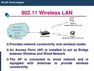
Interdisciplinary and multi-institutional collaborative cyberinfrastructure environment for research education, and public safety activities. Enabled by a National Science Foundation funded high-speed wireless network, which stretches across a vast and diverse geographic region. Allows for real-time data transfers with many hard-to-reach locations. Traffic examples include high-volume bulk data (e.g., astronomy) and the aggregation of continuous traffic generated at many sensors throughout the coverage region (e.g., seismic, weather, cameras).
HPWREN topology, December 2000 Backbone/relay node Astronomy science site Biology science site Earth science site University site Researcher location Native American site First Responder site 155Mbps FDX 6 GHz FCC licensed 155Mbps FDX 11 GHz FCC licensed 45Mbps FDX 6 GHz FCC licensed 45Mbps FDX 11 GHz FCC licensed 45Mbps FDX 5.8 GHz unlicensed 45Mbps-class HDX 4.9GHz 45Mbps-class HDX 5.8GHz unlicensed ~8Mbps HDX 2.4/5.8 GHz unlicensed ~3Mbps HDX 2.4 GHz unlicensed 115kbps HDX 900 MHz unlicensed 56kbps via RCS network dashed = planned Pala Native American Reservation UCSD Mount Laguna Observatory approximately 50 miles:
HPWREN topology, December 2010 Backbone/relay node Astronomy science site Biology science site Earth science site University site Researcher location Native American site First Responder site 155Mbps FDX 6 GHz FCC licensed 155Mbps FDX 11 GHz FCC licensed 45Mbps FDX 6 GHz FCC licensed 45Mbps FDX 11 GHz FCC licensed 45Mbps FDX 5.8 GHz unlicensed 45Mbps-class HDX 4.9GHz 45Mbps-class HDX 5.8GHz unlicensed ~8Mbps HDX 2.4/5.8 GHz unlicensed ~3Mbps HDX 2.4 GHz unlicensed 115kbps HDX 900 MHz unlicensed 56kbps via RCS network dashed = planned WIDC KYVW KNW B081 BDC PFO GVDA Santa Rosa WMC RDM AZRY CRY BZN SND KSW SMER FRD DHL MPO SO P474 SLMS LVA2 BVDA SCS GLRS P478 P486 MTGY MVFD P510 WLA P483 CRRS GMPK RMNA USGC DSME CWC P506 P499 P480 P509 CE MONP UCSD 70+ miles to SCI P497 MLO DESC P494 P473 IID2 SDSU P500 CNM PL P066 POTR NSSS to CI and PEMEX approximately 50 miles: Note: locations are approximate
CDF demonstrationFebruary 2001 http://www.fire.ca.gov/
Coyote Fire HPWREN connection Palomar Mountain relay July 2003 Cuyamaca Mountain HPWREN backbone site Fire operations relay Operations camp
Various real-time network cameras for environmental observations
HPWREN topology, 360 degree cameras Backbone/relay node Astronomy science site Biology science site Earth science site University site Researcher location Native American site First Responder site 155Mbps FDX 6 GHz FCC licensed 155Mbps FDX 11 GHz FCC licensed 45Mbps FDX 6 GHz FCC licensed 45Mbps FDX 11 GHz FCC licensed 45Mbps FDX 5.8 GHz unlicensed 45Mbps-class HDX 4.9GHz 45Mbps-class HDX 5.8GHz unlicensed ~8Mbps HDX 2.4/5.8 GHz unlicensed ~3Mbps HDX 2.4 GHz unlicensed 115kbps HDX 900 MHz unlicensed 56kbps via RCS network dashed = planned WIDC PSAP KYVW COTD KNW B081 BDC PFO GVDA Santa Rosa WMC RDM AZRY CRY BZN SND KSW FRD SMER DHL SO P474 SLMS MPO LVA2 BVDA SCS GLRS P478 P486 MTGY MVFD P510 WLA P483 CRRS GMPK RMNA USGC DSME CWC P506 P499 P480 P509 CE MONP UCSD 70+ miles to SCI P497 MLO DESC P494 P473 IID2 SDSU P500 CNM PL P066 POTR NSSS to CI and PEMEX Red circles: existing cameras Yellow circles: suggested sites approximately 50 miles: Note: locations are approximate
Mount Laguna sensor instrumentation anemometer 3D ultrasonic anemometer solar radiation Pan-tilt-zoom camera tipping rainbucket support equipment temperature relative humidity data logger barometric pressure fuel moisture fuel temperature
HPWREN topology, real-time met sensors Backbone/relay node Astronomy science site Biology science site Earth science site University site Researcher location Native American site First Responder site 155Mbps FDX 6 GHz FCC licensed 155Mbps FDX 11 GHz FCC licensed 45Mbps FDX 6 GHz FCC licensed 45Mbps FDX 11 GHz FCC licensed 45Mbps FDX 5.8 GHz unlicensed 45Mbps-class HDX 4.9GHz 45Mbps-class HDX 5.8GHz unlicensed ~8Mbps HDX 2.4/5.8 GHz unlicensed ~3Mbps HDX 2.4 GHz unlicensed 115kbps HDX 900 MHz unlicensed 56kbps via RCS network dashed = planned WIDC PSAP KYVW COTD KNW B081 BDC PFO GVDA Santa Rosa WMC RDM AZRY CRY BZN SND KSW FRD SMER DHL SO P474 SLMS MPO LVA2 BVDA SCS GLRS P478 P486 MTGY MVFD P510 WLA P483 CRRS GMPK RMNA USGC DSME CWC P506 P499 P480 P509 CE MONP UCSD 70+ miles to SCI P497 MLO DESC P494 P473 IID2 SDSU P500 CNM PL P066 POTR NSSS to CI and PEMEX Red circles: 1/sec wind data Yellow circles: 1/minute wind data approximately 50 miles: Note: locations are approximate
Real-time data based alerts Trigger real-time computer-generated alerts, if: condition “A” AND condition “B” AND condition “C” OR condition “D” exists, in which case several San Diego emergency officers are being paged or emailed during such alert conditions, based on HPWREN data parameterization by a CDF Division Chief. This system has been in operation since 2004. Relative Humidity Wind speed Wind direction Fuel moisture Date: Wed, 4 Aug 2010 09:31:05 -0700 Subject: URGENT weather sensor alert LP: RH=26.1 WD=135.2 WS=1.9 FM=6.8 AT=80.7 at 20100804.093100 More details at http://hpwren.ucsd.edu/Sensors/
Water quality sensor output 172.23.1.221 NPS:Test:Hydro:1:0 1237308123 33.02667 -116.95965 1568 S=1 T=64.8(F) B=28.4("Hg) pH=-15.2 C=952.3(uS/cm) DO=13467(ug/L) 172.23.1.221 sensor origin Internet address NPS:Test:Hydro:1:0 sensor identification 1237308123 time stamp (1237308123 = March 17, 2009 09:42:03) 33.02667 GPS latitude of sensor location (degrees) -116.95965 GPS longitude of sensor location (degrees) 1568 GPS elevation of the sensor location (feet) S=1 data sample number in the current measurement cycle T=64.8(F) obtained temperature in F B=28.4("Hg) obtained barometric pressure in inch-Hg pH=-15.2 pH value (the sensor was not calibrated) C=952.3(uS/cm) conductivity in uS/cm DO=13467(ug/L) dissolved oxygen in ug/L USB-connected wireless network connection for real-time or near-real-time data uploads Serial line-connected multi-parameter water quality probe Small laptop computer/controller USB-connected GPS receiver for geolocation and time tagging
Potential incident management scenario concept operations center Real-time sensor telemetry (video, high resolution stills, …) Perimeter weather station Perimeter weather station command post Incident area Perimeter weather station
Post-incident research concept 3D ultrasonic anemometer
Incident-based sensor alert concept Centralized analysis and automated alert generation Event-deployed networked sensors Raw sensor data Wildland fire incident Configuration of alert parameters Computer-generated alerts Notification to active firefighters about critical environmental changes Command center