Download

1 / 30
710 likes | 1.52k Vues
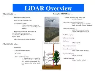
LiDAR. An Introduction and real-world applications. Presented by Steven Menefee Mahinda Abeykoon. LiDAR - Outline. Introduction to LiDAR What is it? History Platforms Major Components Acquisition Resultant Raw Data LiDAR Data Derivatives Real-World Applications

E N D
LiDAR An Introduction and real-world applications Presented by Steven Menefee Mahinda Abeykoon
LiDAR - Outline • Introduction to LiDAR • What is it? • History • Platforms • Major Components • Acquisition • Resultant Raw Data • LiDAR Data Derivatives • Real-World Applications • Sedgwick County LiDAR • How was it collected • Data received • What did we use it for • Q/A Image courtesy ASPRS
LiDAR – So What is it? • LiDAR - Light Detection And Ranging • Light = “Active” Laser • Detection = Laser is reflected and detected by a receiver • Ranging = Distance (Time x Speed of Light/2) • Analogies • Bat • Lightning/Thunder • Drop rock .0001 secs .0002secs 186,282 mi/sec = 18.6 Miles / 2 * .0001 secs Image courtesy DougDraws
Modern LiDAR – A Brief History • Why ? • NASA – Measure Atmospheric properties • When? • 60s – First instruments • 70s – Airborne Profilers • 80s – GPS/INS • 90s – Scanners replace Profilers • 2000s – Heavy commercialization • Why so prevalent now? • Hardware more capable (DGPS, more capable scanners) • Software more capable (handle more points)
LiDAR Platforms • Airborne (Our focus) • Rotary • Fixed wing • Spaceborne • Topography • Atmosphere • Terrestrial • Mobile –Driverless Car • Static • Wind Turbine • Police Images courtesy Penn State, NASA, The Economist, MattersNetwork, Photocop, Geoinformatics
Airborne LiDAR - Components • Global Positioning System • Laser System • Laser Source • Scanning Mechanism (swath) • Laser Detector • Inertial Navigation System (INS) • Computer • Aircraft
Components - GPS • Major hurdle for Airborne LiDAR • Need 4 Satellites • Base Station (known location) • Differential GPS (DGPS) required for accuracy • Provides location of Aircraft to the cm GPS Base Station (Differential Correction)
Components – Laser System • Laser Source • Why laser? • Monochromatic • Directional (unlike flashlight) • Pulse Rate (around 100-150 kHz) • Infrared • Forms cone, not line (misconception) • Scanning Mirror Mechanism • Allows for swath • Types (next slide) • Laser Detector/Receiver Beam Divergence Post Spacing Laser Footprint
Components – Inertial Navigation System • Aircraft not stationary • Records Attitude • Angle the Laser is pointing • Small degrees = Big Impact Image courtesy The Blaze, Remote Sensing Core Curriculum
Components – Computer • Ties together all of components • Records thousands of pts/sec (calculates) • 103 mb to 1.4 gb per Sq Mi (stores) • Allows for on-the-fly (realtime) georeferenced points
Components - Visual GPS Satellites Inertial Navigation System 37.6749,-97.9282,3329 37.5023,-97.0823,3923 37.9234,-97.3523,3866 37.3432,-97.6432,3502 Aircraft Computer Laser/Scanning Mechanism 0.1932,-0.6013,3 0.2230,-0.0301,1 0.4321,-0.6321,5 0.1223,-0.5623,7 Differential Corrections Laser Receiver GPS Base Station (Known Point) 37.3362, -97.6462, 1200
Acquisition – Single Return Point Cloud Posting Density Height Along Track Post Spacing Cross Track Post Spacing
Acquisition –Multiple Returns Beam Divergence 1st Return Height 2nd Return 5km 3rd Return 4th Return 1 km Not always the ground 0.3m 1.5m
Multiple Returns – Real Visual Image courtesy Hans-Erik Anderson
Common Point Data Formats • ASCII (.txt) • Simple Text • Easily Read • Not Proprietary • Long Processing Time • LAS (.las) • Binary file • Not Proprietary • Must have software • Efficient/Fast/Header Image courtesy NOAA
LiDAR Accuracy • Dependent upon • Scan Angle • Flying Height • Pulse Rate • GPS Configuration • Base Station Distance • Elevation ≈ 0.2 to 1 ft • Horizontal ≈ 0.3 to 1.5 ft • Talk with vendor Image courtesy Merchant Circle
LiDAR – Advantages/Disadvantages Advantages Disadvantages • Millions of Points • Day or Night • Quick turnaround • Penetrate Canopy Gaps • Rule of thumb - sunshine • Massive Datasets • Indiscriminate • No Breaklines • Abrupt breaks in elevation • Rivers, buildings, etc
LiDAR Derivatives Digital Elevation Models Contours TIN Hillshade Slope Aspect
Derivatives – Digital Elevation Models • Most common derivatives • Easier than Managing Mass Points • Modeling based on surfaces • Interpolation between points • DTM–Digital Terrain Model • Bare Earth – Points Filtered • Normally Breaklines Enforced • Hydrologic modeling • DSM–Digital Surface Model • First returns • 3D Visualization • Line of Sight Applications • TIN–Triangulated Irregular Network • Vector • Quick rendering TIN Images courtesy Aerometrex and Wikipedia
Derivatives - Contours • Vector Representation • Lines of equal Elevation • Easy to Read • Draws Quickly • Familiarity
Derivatives - Hillshade • Theoretical Light Source • Visualize in 3D • DEM Overlay • Cartographic
Derivatives – Slope/Aspect • Slope • Steepness • Rate of Change • Aspect • Cardinal Direction • “Slope Direction”
LiDAR - Applications Images courtesy Oregon State University
Real-World Applications – Hydrology • FEMA Floodplain Maps • National Research Council, 2007 - ”LiDAR is the most cost effective technology to acquire elevation information over large regions to support floodplain mapping to FEMA accuracy standards” • Green – LiDAR, Red - FEMA • Watersheds • Elevation Key • Drop of water Images courtesy NOAA, John Dorman NC Flood Mapping Program, William & Mary, Directions Mag, N. Carolina Cooperating Technical State
Real-World Applications – Line of Sight • Good use of DSM • Radio/Cell Phone Towers • Planning and Zoning • Event Security Image courtesy ESRI
Real-World Applications – Solar Potential • Gauge Solar Energy Potential • Slope (angle) /Aspect (direction) Image courtesy ESRI
Real-World Applications – Forestry • Canopy Height • $3/acre vs $30/hr • Hours vs Years • Canopy Fuel Capacity • Timber Inventory Images courtesy Oregon State University
Real-World Applications – Utilities • Map Right of Way Corridors • Encroachments • Powerline Curvature/Clearance Images courtesy Penn State, Geoplace, Geoinformatics,
Thank you for your time! Please save all tough questions for Mahinda