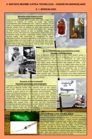
Download
1 / 16
160 likes | 308 Vues
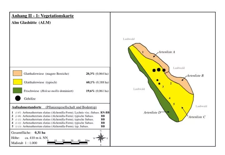
Anhang II - 1: Vegetationskarte. Alm Glashütte (ALM). Laubwald. Artenliste A. 1. Laubwald. Glatthaferwiese (magere Bereiche) 20,3% (0,064 ha). Artenliste B. Glatthaferwiese (typisch) 60,1% (0,188 ha). 2. 3. Laubwald.

E N D
Anhang II - 1: Vegetationskarte Alm Glashütte (ALM) Laubwald Artenliste A 1 Laubwald Glatthaferwiese (magere Bereiche) 20,3% (0,064 ha) Artenliste B Glatthaferwiese (typisch) 60,1% (0,188 ha) 2 3 Laubwald Frischwiese (Holcus mollis dominiert) 19,6% (0,061 ha) 4 Gehölze 5 Laubwald Aufnahmestandorte (Pflanzengesellschaft und Bodentyp) Artenliste D 1(1-07) Arrhenatheretum elatius (Alchemilla-Form); Lychnis visc.-Subass. RN-BB 2(1-09) Arrhenatheretum elatius (Alchemilla-Form); typische Subass. BB Artenliste C 3(1-11) Arrhenatheretum elatius (Alchemilla-Form); typische Subass. BB 4(1-12) Arrhenatheretum elatius (Alchemilla-Form); typische Subass. BB 5(1-13) Arrhenatheretum elatius (Alchemilla-Form); typ. Subass. BB Gesamtfläche: 0,31 ha Höhe: ca. 410 m ü. NN 0 10 20 30 40 50m Maßstab 1 : 1.000
Anhang II - 2: Vegetationskarte Krachwitzwiesen Glashütte (KRW) Artenliste H Laubwald Laubwald Artenliste D Artenliste C Glatthaferwiese (magere Bereiche) 21,3% (0,195 ha) 3 4 Glatthaferwiese (typisch) 58,7% (0,537 ha) Frischwiese (Holcus mollis dominiert) 20,0% (0,183 ha) Laubwald Gehölze Artenliste A Artenliste F Aufnahmestandorte (Pflanzengesellschaft und Bodentyp) Gärten Artenliste B 1(1-01) Arrhenatheretum elatius (Alchemilla-Form); Lychnis visc.-Subass. RN-BB 2(1-02) Arrhenatheretum elatius (Alchemilla-Form); Lychnis visc.-Subass. BB 1 3(1-03) Arrhenatheretum elatius (Alchemilla-Form); Lychnis visc.-Subass. BB 4(1-10) Arrhenatheretum elatius (Alchemilla-Form); typische Subass. BB 2 Artenliste E Gesamtfläche: 0,92 ha Artenliste G Höhe: ca. 420 m ü. NN Laubwald 0 10 20 30 40 50m Maßstab 1 : 1.500
Anhang II - 3: Vegetationskarte Sonnenleite Glashütte (SON) Artenliste A 4 Laubwald Laubwald 1 2 Glatthaferwiese (magere Bereiche) 60,3% (0,254 ha) Glatthaferwiese (typisch) 39,7% (0,167 ha) Artenliste B 3 Gehölze 5 Laubwald Aufnahmestandorte (Pflanzengesellschaft und Bodentyp) 1(1-04) Arrhenatheretum elatius (Alchemilla-Form); Lychnis visc.-Subass. BB 2(1-06) Arrhenatheretum elatius (Alchemilla-Form); Lychnis visc.-Subass. BB 3(1-05) Arrhenatheretum elatius (Alchemilla-Form); Lychnis visc.-Subass. BB Siedlung 4(1-08) Arrhenatheretum elatius (Alchemilla-Form); typische Subass. BB 5(1-14) Arrhenatheretum elatius (Alchemilla-Form); typische Subass. BB Gesamtfläche: 0,42 ha Höhe: ca. 390 m ü. NN 0 10 20 30 40 50m Maßstab 1 : 1.000
Anhang II - 4: Vegetationskarte Wiese an der Bärenfelser Mühle (BÄR) Bergwiese (verschiedene Ausprägungen) 44,6% (0,406 ha) Frischwiese (Holcus mollis dominiert) 24,7% (0,224 ha) Borstgrasrasen 3,4% (0,046 ha) Artenliste B Straße Wiesenbrache anschließend Laubwald Feuchtwiese (Juncus acutiflorus dominiert) 10,1% (0,092 ha) 6 Siedlung (Gärten) 3 Feuchtwiese (Übergänge zu feuchter Bergwiese) 1,9% (0,018 ha) 5 Kleinseggenrasen 6,8% (0,062 ha) 1 4 7 Hochstaudenflur (Filipendula ulmaria dominert) 6,8% (0,062 ha) 2 Gehölze Park Siedlung (Gärten) Aufnahmestandorte (Pflanzengesellschaft und Bodentyp) 1(2-04) Geranio-Trisetetum; Nardus stricta-Subassoziation, typ. Var. BB 2(2-10) Geranio-Trisetetum; typische Subassoziation, typ. Var. BB Artenliste A 3(2-09) Geranio-Trisetetum; typische Subassoziation, typ. Var. BB 4(4-01) Polygalo-Nardetum strictae BB 5 (3-01) Crepido-Juncetum acutiflori GMg 6 (3-18) Caricion fucsae-Calthion-Gesellschaft GMg 7 (5-15) Parnassio-Caricetum fuscae GMg Gesamtfläche: 0,91 ha Höhe: ca. 590 m ü. NN 0 10 20 30 40 50m Maßstab 1 : 1.250
Anhang II - 5: Vegetationskarte Wiese im Becherbachtal (BEC) Aufnahmestandorte (Pflanzengesellschaft und Bodentyp) Bergwiese (Übergänge zu Borstgrasrasen) 31,9% (0,469 ha) 1(2-01) Geranio-Trisetetum; Nardus stricta-Subassoziation, typ. Var. BB (Alopecurus pratensis und Dactylis glomerata dominiert) Bergwiesen-Brache 25,7% (0,378 ha) 2(2-07) Geranio-Trisetetum; Nardus stricta-Subass., feuchtere Var. BB 3(3-17) Chaerophyllum hirsutum-Gesellschaft GGa (Senecio ovatus und Dactylis glomerata dominiert) 15,7% (0,231 ha) Bergwiesen-Brache 4(3-03) Crepido-Juncetum acutiflori HN-GH 5 (5-08) Caricetum fuscae; feuchtwiesenartenreiche Subassoziation HN Bergwiesen-Brache (Holcus mollis dominiert) 4,1% (0,059 ha) ZB1 (zusätzliche Bodenaufnahme)GMn Feuchtwiese (Chaerophyllum hirsutum dominiert) 9,2% (0,135 ha) Gesamtfläche: 1,47 ha Höhe: ca. 710 m ü. NN Feuchtwiese (Juncus acutiflorus dominiert) 6,3% (0,092 ha) 0 20 40 60 80 100m Maßstab 1 : 2.000 Feuchtwiese (Juncus effusus dominiert) 5,9% (0,087 ha) Kleinseggenrasen 1,1% (0,017 ha) Gehölze Artenliste B Nadelwald Artenliste E ZB1 Artenliste A 1 3 Bach, Weg, anschließend Nadelwald 4 5 2 Artenliste D Artenliste F Bach, anschließend Nadelwald Artenliste C
Anhang II - 6: Vegetationskarte Bekassinenwiese Johnsbach (BEK) Weg, anschließend Intensivgrünland Feuchtwiese (Juncus acutiflorus dominiert) 39,1% (0,363 ha) Artenliste B Artenliste A Feuchtwiese (Lysimachia vulgaris dominiert) 4,7% (0,043 ha) Artenliste C Feuchtwiese (Menyanthes trifoliata dominiert) 2,1% (0,020 ha) Feuchtwiese (Scirpus sylvaticus dominiert) 0,6% (0,005 ha) 4 Kleinseggenrasen 14,0% (0,130 ha) 3 Intensivgrünland Bergwiese (Übergänge zu Borstgrasrasen) 1,7% (0,016 ha) 2 (Alopecurus pratensis und Holcus lanatus dominiert) Frischwiese 25,7% (0,239 ha) Intensivgrünland Artenliste D uferbegleitende Vegetation an Graben 12,2% (0,114 ha) 5 ZB1 1 Gehölze Artenliste E Aufnahmestandorte (Pflanzengesellschaft und Bodentyp) 1(3-07) Crepido-Juncetum acutiflori HN-GH 2(3-06) Crepido-Juncetum acutiflori HN-GH 3(5-11) Caricetum fuscae; feuchtwiesenartenreiche Subassoziation HN 4(5-12) Caricetum fuscae; feuchtwiesenartenreiche Subassoziation HN-GH Artenliste F 5(2-02) Geranio-Trisetetum; Nardus stricta-Subassoziation, typ. Var. BB ZB1 (zusätzliche Bodenaufnahme)BB Gesamtfläche: 0,93 ha Höhe: ca. 595 m ü. NN Intensivgrünland 0 10 20 30 40 50m Maßstab 1 : 1.250
Anhang II - 7: Vegetationskarte Artenliste C Böhmische Wiesen bei Rehefeld-Zaunhaus (BÖH) Artenliste E Bergwiese (frisch) 67,4% (3,879 ha) Bach; anschließend Nadelwald, Lichtung (tschechisches Staatsgebiet) Bergwiese (feucht) 10,5% (0,603 ha) Nadelwald (NSG Hemmschuh) Feuchtwiese (Juncus filiformis dominiert) 8,6% (0,496 ha) Feuchtwiese (Übergänge zu Kleinseggenrasen) 9,4% (0,538 ha) Feuchtwiese (Carex gracilis dominiert) 0,3% (0,018 ha) Artenliste D Artenliste A Kleinseggenrasen 1,3% (0,076 ha) 1 2 (Übergänge zu Zwischenmoor, mit Eriophorum vaginatum) 2,5% (0,144 ha) Kleinseggenrasen Aufnahmestandorte (Pflanzengesellschaft und Bodentyp) 5 Artenliste I 1(2-08) Geranio-Trisetetum; Nardus stricta-Subass., feuchtere Var. BB Artenliste H 2(3-15) Juncus filiformis-Gesellschaft GGa Artenliste F 3(3-11) Caricion fuscae-Calthion-Gesellschaft HN 3 4(3-10) Caricion fuscae-Calthion-Gesellschaft GM 5 (5-01) Caricetum fuscae, torfmoosreiche Subassoziation HN Artenliste G Gesamtfläche: 5,75 ha Artenliste B 4 Höhe: ca. 710 m ü. NN 0 50 100 150 200m Maßstab 1 : 6.000
Anhang II - 8: Vegetationskarte 7 Wiese am Sportplatz Hennersdorf (HEN) Bergwiese 14,6% (0,237 ha) (Holcus mollis und Anthriscus sylvestris dominiert) 14,3% (0,231 ha) Frischwiese Feuchtwiese (Juncus acutiflorus dominiert) 35,9% (0,581 ha) Kleinseggenrasen 12,8% (0,208 ha) (mit kleinflächig eingestreuten f euchten Borstgrasrasen) Kleinseggenrasen 8,4% (0,136 ha) Nadelwald (kleinflächiges Mosaik verschiedener Typen, Juncus effusus dominiert) 13,7% (0,221 ha) Feuchtwiese Artenliste G Artenliste A Borstgrasrasen 0,3% (0,006 ha) Artenliste C 1 Zwischenmoor (0,088 ha) 4 5 Artenliste F Aufnahmestandorte (Pflanzengesellschaft und Bodentyp) 3 1(2-06) Geranio-Trisetetum; Nardus stricta-Subass., feuchtere Var. SS 2(3-05) Crepido-Juncetum acutiflori HN 3(5-07) Caricetum fuscae; torfmoosreiche Subassoziation SSm 4(5-09) Caricetum fuscae; feuchtwiesenartenreichere Subassoziation SSm 2 5 (5-10)Caricetum fuscae; feuchtwiesenartenreichere Subassoziation HN Artenliste E 6 (4-07)Violion-Basalgesellschaft SS Artenliste H,I 6 7 (6-01)Eriophorum vaginatum-Oxycocco-Sphagnetea-Gesellschaft HNu Artenliste D Gesamtfläche: 1,62 ha Artenliste B Höhe: ca. 620 m ü. NN Nadelwald 0 20 40 60 80 100m Maßstab 1 : 2.000
Anhang II - 9: Vegetationskarte Wiese Klärwerk Lauenstein (KWL) Laubwald ausgekoppelter Bereich (0,1 ha) 2 1 Klärwerk Laubwald Bergwiese 97,2% (0,599 ha) Kleinseggenrasen (basiphil) 2,8% (0,018 ha) Aufnahmestandorte (Pflanzengesellschaft und Bodentyp) temporäre Nutzung als Viehweide (0,5 ha) 1(5-16) Parnassio-Caricetum fuscae GNg 2(2-18) Geranio-Trisetetum; typische Subassoziation, typ. Var. BB Steinrücke, anschließend Grünland Gesamtfläche: 0, 62 ha Höhe: ca. 470 m ü. NN 0 10 20 30 40 50m Maßstab 1 : 1.000
Anhang II - 10: Vegetationskarte Wiese bei Hartmannsdorf-Neubau (NEU) Bergwiese (verschiedene Ausprägungen) 62,4% (0,833 ha) Artenliste E Feuchtwiese (Juncus acutiflorus dominiert) 13,8% (0,185 ha) 4 Feuchtwiese (Übergang zu Kleinseggenrasen) 2,2% (0,029 ha) 3 Straße, anschließend Intensivgrünland 2 Feuchtwiese (Scirpus sylvaticus dominiert) 0,6% (0,008 ha) Artenliste B Kleinseggenrasen 2,6% (0,035 ha) Artenliste A Artenliste C uferbegleitende Vegetation am Bach 4,2% (0,056 ha) Saumvegetation an Straßenböschung 14,2% (0,190 ha) 5 Artenliste D Artenliste F 6 Gehölze Aufnahmestandorte (Pflanzengesellschaft und Bodentyp) 1 (Bach), anschließend Mischwald 1(2-21) Geranio-Trisetetum; typische Subass., westliche Var. BB 2(2-23) Geranio-Trisetetum; typische Subass., westliche Var. 3(2-22) Geranio-Trisetetum; typische Subass., westliche Var. BB 4(3-08) Crepido-Juncetum acutiflori SS 5 (3-12) Caricion fuscae-Calthion-Gesellschaft SSm 6 (5-13) Caricetum fuscae; feuchtwiesenartenreiche Subassoziation GMg Gesamtfläche: 1,33 ha Höhe: ca. 550 m ü. NN 0 20 40 60 80 100m Maßstab 1 : 2.000
Anhang II - 11: Vegetationskarte Wiese am Phillip-Müller-Lager Altenberg (PML) Artenliste C Bergwiese (Übergänge zu Borstgrasrasen) 46,5% (0,573 ha) Grünland 4 Borstgrasrasen (frisch) 29,4% (0,360 ha) Borstgrasrasen (feucht) 1,5% (0,019 ha) Nadelwald Artenliste D Borstgrasrasen (wechselfeucht) 0,5% (0,007 ha) 3 Artenliste A Feuchtwiese (Juncus acutiflorus dominiert) 17,8% (0,219 ha) bachbegleitendes Weidengebüsch Kleinseggenrasen 4,2% (0,052 ha) 2 Gehölze 1 5 Aufnahmestandorte (Pflanzengesellschaft und Bodentyp) Artenliste B Steinrücke, anschließend Intensivgrünland 1(2-03) Geranio-Trisetetum; Nardus stricta-Subassoziation, typ. Var. BB 2(4-05) Polygalo-Nardetum strictae SS Steinrücke, anschließend Intensivgrünland 3(4-18) Juncetum squarrosi SS 4(3-04) Crepido-Juncetum acutiflori HN 5 (5-05) Caricetum fuscae; torfmoosreiche Subassoziation SSm Gesamtfläche: 1,23 ha Höhe: ca. 725 m ü. NN 0 10 20 30 40 50m Maßstab 1 : 1.500
Anhang II - 12: Vegetationskarte Wiese im Pöbelbachtal (PÖB) Nadelwald Artenliste D Artenliste A 2 ZB1 3 Kleinseggenrasen 46,4% (0,057 ha) 1 Lichtung Feuchtwiese (brachliegend) 50,3% (0,062 ha) Nadelwald Feuchtwiese (Juncus acutiflorus dominiert) 3,3% (0,004 ha) ZB2 Gehölze Artenliste B,C Nadelwald Aufnahmestandorte (Pflanzengesellschaft und Bodentyp) 1(5-03) Caricetum fuscae; torfmoosreichen Subassoziation HN 2(5-04) Caricetum fuscae; torfmoosreichen Subassoziation HN-GH 3(5-02) Caricetum fuscae; torfmoosreichen Subassoziation HN ZB1(zusätzliche Bodenaufnahme)HN ZB2(zusätzliche Bodenaufnahme)HN-GH Gesamtfläche: 0,12 ha Höhe: ca. 685 m ü. NN 0 10 20 30 40 50m Maßstab 1 : 1.000
Anhang II - 13: Vegetationskarte Wiese an der Röthenbacher Mühle (RBM) Nadelwald Artenliste B (hinterer Teil) 4 Artenliste C 5 Bergwiese 87,9% (0,436 ha) Artenliste D Feuchtwiese (Juncus acutiflorus dominiert) 6,4% (0,032 ha) 2 Feuchtwiese (Übergänge zu feuchter Bergwiese) 2,3% (0,012 ha) Böschung mit Laubwald, anschließend Grünland Feuchtwiese (Scirpus sylvaticus dominiert) 1,1% (0,006 ha) Nadelwald bachbegleitende feuchte Hochstaudenflur 2,2% (0,011 ha) 3 1 Gehölze Aufnahmestandorte (Pflanzengesellschaft und Bodentyp) Artenliste A (vorderer Teil) 1(2-19) Geranio-Trisetetum; typische Subassoziation, westl. Var. BB 2(2-20) Geranio-Trisetetum; typische Subassoziation, westl. Var. BB 3(3-09) Crepido-Juncetum acutiflori SGm 4(3-13) Scirpetum sylvatici GGh 5 (3-19) Calthion-Basalgesellschaft BB-GG Gesamtfläche: 0,49 ha Höhe: ca. 435 m ü. NN 0 10 20 30 40 50m Maßstab 1 : 1.000
Anhang II - 14: Vegetationskarte Intensivgrünland Steinrückenwiese Sadisdorf (SAD) (Deschampsia flexuosa dominiert, tlw. Bergwiesencharkter) Borstgrasrasen 46,6% (0,376 ha) Intensivgrünland Borstgrasrasen (feucht) 3,5% (0,028 ha) Borstgrasrasen (frisch, typisch) 3,4% (0,029 ha) 1 Feuchtwiese (Lysimachia vulgaris dominiert) 17,6% (0,142 ha) Feuchtwiese (Scirpus sylvaticus dominiert) 0,9% (0,007 ha) Feuchtwiese (Juncus acutiflorus dominiert) 0,7% (0,006 ha) Acker ZB1 3 Feuchtwiese (Juncus filiformis dominiert) 0,2% (0,002 ha) 4 Frischwiese (Holcus mollis dominiert) 26,9% (0,217 ha) 5 Artenliste A Gehölze 2 Aufnahmestandorte (Pflanzengesellschaft und Bodentyp) Artenliste C 1(4-02) Polygalo-Nardetum strictae SS 2(4-06) Violion-Basalgesellschaft SS 3(4-12) Juncetum squarrosi SS 4(4-17) Juncetum squarrosi SS Artenliste B 5(3-16) Juncetum filiformis SS ZB1(zusätzliche Bodenaufnahme) SS Gesamtfläche: 0,81 ha Höhe: ca. 595 m ü. NN 0 10 20 30 40 50m Maßstab 1 : 1.000 Acker
Anhang II - 15: Vegetationskarte Wiese am (ehemaligen) Sanatorium Altenberg (SAN) Bergwiese 37,7% (0,787 ha) Artenliste B 4 Bergwiesen-Brache 20,8% (0,435 ha) Steinrücke, anschließend Grünland 3 Borstgrasrasen 21,8% (0,456 ha) Feuchtwiese (Juncus acutiflorus dominiert) 7,1% (0,148 ha) 8 Straße (B170), anschließend Nadelwald Feuchtwiese (Juncus filiformis dominiert) 0,4% (0,008 ha) 9 Kleinseggenrasen 1,6% (0,034 ha) 7 Saumvegetation an Straßenböschung 10,5% (0,219 ha) Artenliste D Gehölze Artenliste C 6 Aufnahmestandorte (Pflanzengesellschaft und Bodentyp) 5 1(2-12) Geranio-Trisetetum; typische Subassoziation, typische Var. BB Nadelwald 2(2-05) Geranio-Trisetetum; Nardus stricta Subass., typische Var. BB 3(2-24) Geranio-Trisetetum; Holcus mollis-Brachestadium SS 4(2-25) Geranio-Trisetetum; Holcus mollis-Brachestadium SS 5(4-15) Juncetum squarrosi SS 6(4-14) Juncetum squarrosi SS 2 7(3-02) Crepido-Juncetum acutiflori GM Artenliste A 8(3-14) Juncus filiformis-Gesellschaft SSm 1 9(5-06) Caricetum fuscae; torfmoosreiche Subassoziation GMg Straße, anschließend Nadelwald Gesamtfläche: 2,09 ha Höhe: ca. 785 m ü. NN 0 20 40 60 80 100m Maßstab 1 : 2.000
Anhang II - 16: Vegetationskarte Wiesen am Steinbruch Lauenstein (SBL) Artenliste B Steinrücke, anschließend Grünland Bergwiese 78,6% (0,610 ha) 2 Steinrücke, anschließend Grünland Bergwiesen-Saum (Holcus mollis dominiert) 9,4% (0,073 ha) 3 Laubwald Bergwiesen-Brache 12,0% (0,093 ha) Steinrücke 1 4 Aufnahmestandorte (Pflanzengesellschaft und Bodentyp) 1(2-13) Geranio-Trisetetum; typische Subassoziation, typ. Var. BB 2(2-14) Geranio-Trisetetum; typische Subassoziation, typ. Var. BB 3(2-16) Geranio-Trisetetum; typische Subassoziation, typ. Var. BB 5 4(2-17) Geranio-Trisetetum; typische Subassoziation, typ. Var. BB Artenliste A 5 (2-15)Geranio-Trisetetum; typische Subassoziation, typ. Var. BB Böschung, anschließend Steinbruch Gesamtfläche: 0,78 ha Höhe: ca. 540 m ü. NN 0 10 20 30 40 50m Maßstab 1 : 1.250