Download
1 / 20
200 likes | 208 Vues
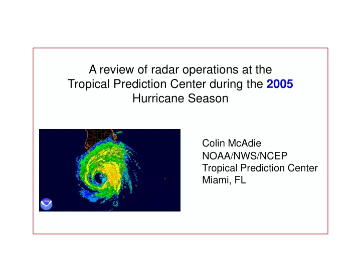
A review of radar operations at the Tropical Prediction Center during the 2005 Hurricane Season. Colin McAdie NOAA/NWS/NCEP Tropical Prediction Center Miami, FL. H. Ophelia 09-15. T.S. Tammy 10-05. T.S. Arlene 06-11. H. Rita 09-24. H. Dennis 07-10. T.S. Cindy 07-15*.

E N D
A review of radar operations at the Tropical Prediction Center during the 2005 Hurricane Season Colin McAdie NOAA/NWS/NCEP Tropical Prediction Center Miami, FL
H. Ophelia 09-15 T.S. Tammy 10-05 T.S. Arlene 06-11 H. Rita 09-24 H. Dennis 07-10 T.S. Cindy 07-15* H. Katrina 08-29 H. Emily 07-20 H. Wilma 10-24 H. Katrina 08-25 H. Rita 09-20 H. Dennis 07-09
2005,AUG,25,1700,26.18,79.51,F,CLOSED CIRCULATION WITH DRY SLOT TO N AND W.,RM,KAMX, 2005,AUG,25,1728,26.19,79.50,F,MAX WND 65 KT S QUAD AT 4730 FT,RM,KAMX, 2005,AUG,25,1801,26.16,79.54,F,MAX WND 77 KT S QUAD AT 5075 FT,RM,KAMX, 2005,AUG,25,1829,26.16,79.63,F,WEAK REF NW SEMICIRCLE...MAX WND 75 KT SE QUAD,RM,KAMX, 2005,AUG,25,1902,26.14,79.67,F,80 KTS S OF CTR AT 3900 FT,RM,KAMX, 2005,AUG,25,1929,26.14,79.74,F,85 KT MAX S QUAD AT 3417 FT JUST S OF CTR,RM,KAMX, 2005,AUG,25,2002,26.07,79.84,F,CENTER RAGGED CMA GOOD ZERO ISODOP,CJM,KAMX, 2005,AUG,25,2030,26.00,79.90,G,INBOUND MAX OVER SE BROWARD 75 KT 2300',CJM,KAMX, 2005,AUG,25,2058,25.98,79.95,G,STRONGEST CONV S EYEWALL KEY BISCAYNE AREA,CJM,KAMX, 2005,AUG,25,2134,25.99,79.96,G,CENTRAL CONV BECOMING MORE SYMMETRICAL,CJM,KAMX, 2005,AUG,25,2204,25.97,80.03,G,- -,CJM,KAMX, 2005,AUG,25,2231,25.96,80.10,G,CENTER OVER COAST BROWARD-DADE COUNTY LINE,CJM,KAMX, 2005,AUG,25,2304,25.96,80.16,G,HIGHEST WINDS OFFSHORE ABOUT 70 KT 1500',CJM,KAMX, 2005,AUG,25,2332,25.89,80.24,G,- -,CJM,KAMX, 2005,AUG,26,0000,25.88,80.31,G,- - ,CJM,KAMX,2005,AUG,26,0034,25.78,80.39,G,TPC IN EYE - CALM OUTSIDE,CJM,KAMX, 2005,AUG,26,0101,25.73,80.46,G,75 KT INBOUND OVER CENTRAL DADE 700 FT ,CJM,KAMX, 2005,AUG,26,0126,25.70,80.53,G,- - ,CJM,KAMX, 2005,AUG,26,0201,25.64,80.60,G,TIGHT VELOCITY COUPLET STILL EVIDENT IN VEL ,CJM,KAMX, 2005,AUG,26,0228,25.61,80.71,G,- - ,CJM,KAMX, 2005,AUG,26,0301,25.58,80.82,G,80 KT AT 900 FT OUTBOUND,CJM,KAMX, 2005,AUG,26,0326,25.56,80.93,G,74 KT AT 1600 FT,HDC,KAMX,
VCP 121 can be effective in reducing range-folding (purple haze) - a well-known problem for 88D tropical cyclone observations. However, problems remain in increasing the velocity measurement increment in VCP 121. 2004 – increasing VMI not possible 2005 – possible, but there appears to be a bug in the VCP 121 code. 2006 – problem should be solved in Build 8
Additional issues – AWIPS display (product legend) should clearly indicate VMI at a glance. Currently, it does not do so. Comms failure at KLIX during landfall emphasized the need for a local (WFO) level II archive.
Significant damage to Unisys dish demonstrated the value of redundancy. In this case, AWIPS remained operational. TDWR provided additional backup.
Conclusions • Central collection of radar data vastly improved, but local backup will ensure that valuable data is not lost during extreme events. • Catastrophic failures are possible. • VCP 121is an effective tool for reducing range-folding (purple haze). A residual bug should be resolved for 2006.