Download
1 / 35
360 likes | 518 Vues
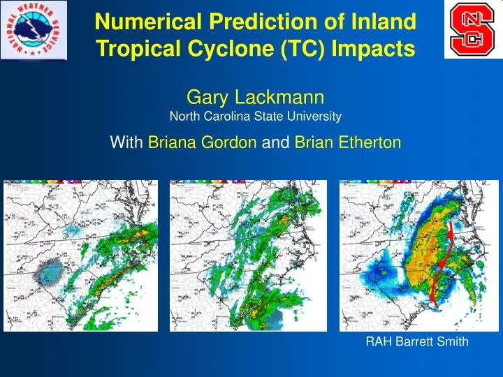
Numerical Prediction of Inland Tropical Cyclone (TC) Impacts Gary Lackmann North Carolina State University With Briana Gordon and Brian Etherton. RAH Barrett Smith. Thank You, NWS! - For providing excellent research topics and ideas - For organizing meeting, being here & participating

E N D
Numerical Prediction of Inland Tropical Cyclone (TC) Impacts Gary Lackmann North Carolina State University With Briana Gordon and Brian Etherton RAH Barrett Smith
Thank You, NWS! - For providing excellent research topics and ideas - For organizing meeting, being here & participating - For helping realize the benefit of applied research - For past and future collaborations
Outline Part I: TC Initialization (Briana Gordon, yesterday) Part II: Research Opportunity (the problem) Part III: Collaboration
Hanna (2008) NWS RAH HPChttp://www.hpc.ncep.noaa.gov/tropical/rain/tcrainfall.html Acknowledgement to RAH (Barrett Smith, Jonathan Blaes), HPC (David Roth), OU NMQ Q2RAD http://nmq.ou.edu/
Hanna (2008) Radar summary Barrett Smith, RAH
Hanna (2008) Rain ahead of Hanna: Evaporational cooling, boundary forms Weak cold-air damming develops, enhanced thermal gradient Boundary hypothesized to aid isentropic ascent
Hanna (2008) Example Inland wind prediction – also related to boundary? Strong surface winds east of boundary (unstable), weaker winds to west (heavier precipitation there) Verifying severe weather reports and wind analyses based on spotter reports and other available data: Boundary location not coincidental
Synoptic Preconditioning - Outer circulation gives rise to boundaries, “preconditioning” - Interactions with boundaries, synoptic flow: PREs - Impact timing for approaching TC related to size of storm Srock and Bosart (2009)
Objective: • Improve numerical prediction of inland TC impacts, including QPF and winds • Potential Benefits: • - Credible TC wind & precipitation prediction (incl. ensemble) • - Resolution of outer-core hazards (e.g., spiral bands) • - Improved prediction of TC-synoptic interactions (e.g, boundaries, PREs) • - Dynamical model output useful in connection with wind project
Obstacle: • Operational TC initial conditions very poor • - Esp. w/ strong TC at initial time, close to landfall • Compromises direct dynamical prediction • May compromise prediction of secondary features • - Synoptic interactions (e.g., PREs) • - CAD and thermal boundary formation • Useful ensemble prediction precluded
Recent Example: Initialization of Earl • Operational GFS, NAM, RUC: • - Strong storm at initial time: model too weak (inner core) • - Poor/no representation of spiral bands, outer wind field • - Not just a resolution issue EARL: TPC Best Track: 948 mb NAM, 9/3/00Z: 990 mb GFS, 9/3/00Z: 982 mb
Hurricane Earl (September 2010) 15-20 kt 40+ kt NAM 33-h forecast valid 09Z 3rd (212)
Prerequisite to credible dynamical prediction of inland TC impacts: Improved TC initialization (both inner- and outer-core features)
Part II: Research Opportunity Towards improved numerical prediction of inland TC impacts
HUR-NC: WRF at RENCI for TC Prediction RENCI computing resources allow high-resolution TC simulations (explicit convection) 27-km outer domain, 9-, 3-km mobile inner grids Utilize large computational domain, moving nest vortex-tracking feature of WRF-ARW model Spin up at high resolution offshore, strength, structure closer to observations at landfall
HUR-NC: WRF at RENCI for TC Prediction “Out-of-box” configuration: Promising (3 years) Differences relative to NAM and GFS? Moving-nest tracks TC (3 km): Explict convection Ocean Mixed Layer: Accounts for wake cooling Effective “dynamical downscaling” Main limitation: Initial conditions, esp. with strong storm at initial time (use 0.5° GFS)
WRF Ocean Mixed Layer Model (OML) Ocean Mixed Layer: simple parameterization Only mixing, no upwelling No ocean currents Initial SST field from GFS Specify thermocline depth (m) Specify temperature lapse rate (deg/m)
Ike: 72-hour Forecast SST (°C) No OML OML, 25 m mixed layer OML, 50 m mixed layer OML, 75 m mixed layer
HUR-NC Examples: Earl, initialized 00 UTC 2 September 2010 Domain 1 composite reflectivity (27-km)
HUR-NC Examples: Earl, initialized 00 UTC 2 September 2010 Domains 1, 2, 3 reflectivity (27/9/3) with D1 SLP
NCSU-RENCI HUR-NC 33-h Forecast, initialized 00 UTC 2 Sep, Valid 09Z Friday 3 Sep: 3-km domain Best Track: 955 mb
NAM (212 grid – 40 km) HURNC 3-km > 70kt 33-h wind speed fcsts valid 09Z 3 Sept
HUR-NC Initial Conditions • - Weak initial TC: Acceptable; Strong initial TC: Problematic • - For strong initial TC, several options for improvement: • - GFDL bogus vortex? Doesn’t help much in test cases • - Ensemble Kalman Filter? Computational expense… • Ryan Torn (U Albany) generates EnKF ICs, available • - HRRR 3-km diabatic initialization? Will try, offshore?? • - Perform our own vortex cycling or DA at high resolution? • BUT FIRST… the “science questions”
Science Questions: Initial Conditions - What features must be captured in IC for “good forecasts”? - At what scale must DA be run to capture these features? - What data are needed to capture these features? Hypotheses: - Inland impacts strongly sensitive to initial circulation size - Inclusion of outer-core features required for prediction of synoptic/mesoscale preconditioning
Wind field related to spiral bands, associated diabatic lower-tropospheric PV 20RH 80RH
Science Questions: Inland Impacts • Mechanisms of formation for boundaries? • - Evaporational cooling, solar sheltering critical • - Terrain, cold-air damming? • - Role of TC, synoptic features in establishing boundary? • Predictability of boundary formation? • - Difficult NWP representation of diabatic, cloud-radiation • - Representation of PBL, moist processes in NWP? • Even with correct boundary: QPF, wind forecasts? • - Importance of boundary to total precipitation? • - Strength of influence on stability, surface winds?
Research Plan: Year 1 • Utilize HUR-NC for retrospective cases (testbed) • Evaluate HUR-NC forecasts from different ICs: • Re-run challenging events • Examine sensitivity to size, outer-core features in ICs • Diagnosis of synoptic preconditioning with landfalling TC • Identify optimal strategy for TC ICs
Research Plan: Year 2 • Identify critical IC features and processes for credible TC and inland impact predictions • Address predictability issues for inland boundary formation • Work with inland wind team, link dynamical with statistical models & observations
Research Plan: Year 3 When available, implement improved ICs in ensemble, HUR-NC (Deliverable) Make ICs available for local modeling (Deliverable) Retrospective & real-time runs, evaluate forecasts with various ICs to measure impact (Deliverable) Work with NWS to identify ways to utilize NWP output in forecast process
Collaboration How can the research plan be improved to optimize results, collaborative benefit? What aspects of project would be most useful to the NWS, and in what form? How often should research updates be shared? What training materials, if any, would be helpful?
Collaborative Opportunities • What cases should we use in testing? • What kinds of dynamical NWP output most valuable? • - parameters? - resolution? • - lead time? - tools for NWP manipulation? • - training materials? - high-resolution example cases? • If specialized TC ICs were available, would they be useful in local modeling efforts? • Help us learn about current forecast processes, how high-resolution NWP might fit in? • How can HMT-SE be leveraged in this effort? • - Perhaps high-resolution EnKF analysis?
Acknowledgements Jonathan Blaes for doing a fantastic job coordinating meeting, CSTAR input, etc. and RAH (Darin Figurskey) for hosting NOAA CSTAR program, Sam Contorno, and USWRP, HMT-SE for support (Tim Schneider, Marty Ralph) Regional CSTAR NWS offices (RAH, GSP, ILM, MHX, CAE, CHS, FFC, RNK, LWX, AKQ) National Center Partners: Dave Novak (SPC), Mike Brennan (TPC), Steve Weiss (SPC) NWS Eastern Region Headquarters – Jeff Waldstreicher Barrett Smith (NWSFO RAH) for Hanna materials NWSFO RAH Case Summary Archive: http://www4.ncsu.edu/~nwsfo/storage/cases/20080906/
NCSU-RENCI HUR-NC 78-h Forecast, initialized 00 UTC 31 Aug, Valid 06Z Friday: 27-km domain
NCSU-RENCI HUR-NC 51-h Forecast, initialized 00 UTC 1 Sep, Valid 03Z Friday: 27-km domain
NCSU-RENCI HUR-NC 27-h Forecast, initialized 00 UTC 2 Sep, Valid 03Z Friday: 27-km domain