Download
1 / 1
10 likes | 154 Vues
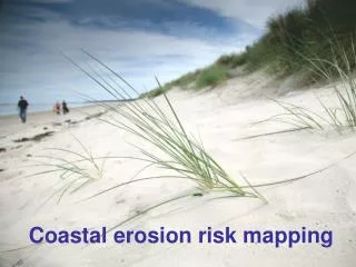
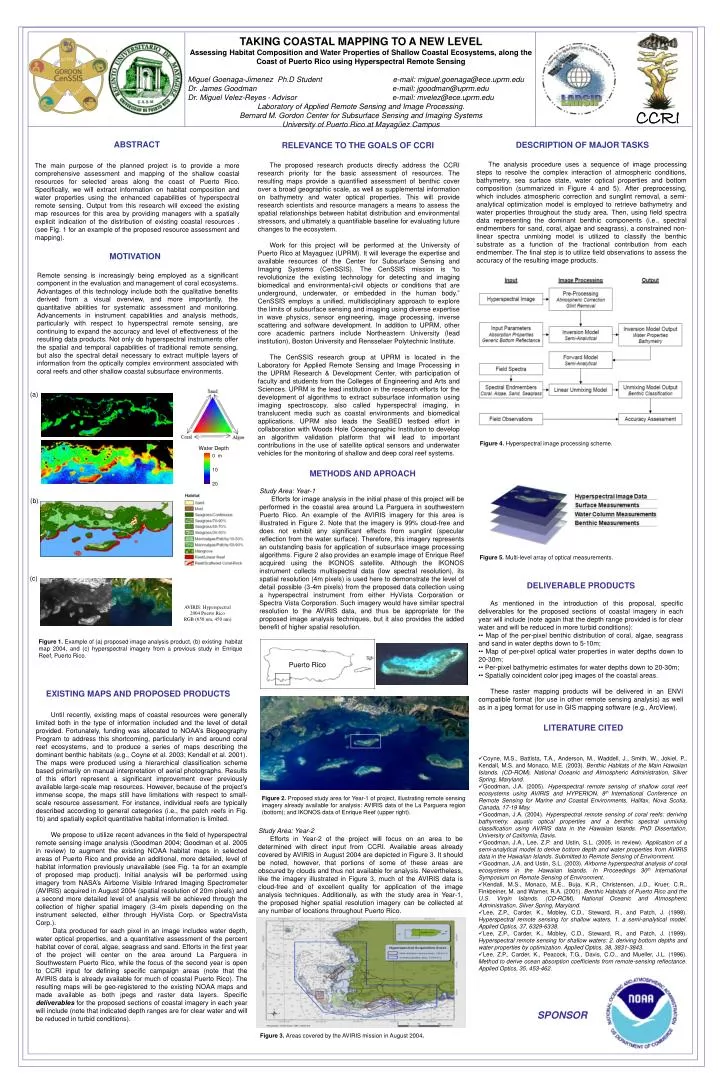
CCRI. Water Depth. 0 m. 10. 20. TAKING COASTAL MAPPING TO A NEW LEVEL Assessing Habitat Composition and Water Properties of Shallow Coastal Ecosystems, along the Coast of Puerto Rico using Hyperspectral Remote Sensing

E N D
CCRI Water Depth 0 m 10 20 TAKING COASTAL MAPPING TO A NEW LEVEL Assessing Habitat Composition and Water Properties of Shallow Coastal Ecosystems, along the Coast of Puerto Rico using Hyperspectral Remote Sensing Miguel Goenaga-Jimenez Ph.D Student e-mail: miguel.goenaga@ece.uprm.edu Dr. James Goodman e-mail: jgoodman@uprm.edu Dr. Miguel Velez-Reyes- Advisor e-mail: mvelez@ece.uprm.edu Laboratory of Applied Remote Sensing and Image Processing. Bernard M. Gordon Center for Subsurface Sensing and Imaging Systems University of Puerto Rico at Mayagüez Campus ABSTRACT DESCRIPTION OF MAJOR TASKS RELEVANCE TO THE GOALS OF CCRI The analysis procedure uses a sequence of image processing steps to resolve the complex interaction of atmospheric conditions, bathymetry, sea surface state, water optical properties and bottom composition (summarized in Figure 4 and 5). After preprocessing, which includes atmospheric correction and sunglint removal, a semi-analytical optimization model is employed to retrieve bathymetry and water properties throughout the study area. Then, using field spectra data representing the dominant benthic components (i.e., spectral endmembers for sand, coral, algae and seagrass), a constrained non-linear spectra unmixing model is utilized to classify the benthic substrate as a function of the fractional contribution from each endmember. The final step is to utilize field observations to assess the accuracy of the resulting image products. The proposed research products directly address the CCRI research priority for the basic assessment of resources. The resulting maps provide a quantified assessment of benthic cover over a broad geographic scale, as well as supplemental information on bathymetry and water optical properties. This will provide research scientists and resource managers a means to assess the spatial relationships between habitat distribution and environmental stressors, and ultimately a quantifiable baseline for evaluating future changes to the ecosystem. Work for this project will be performed at the University of Puerto Rico at Mayaguez (UPRM). It will leverage the expertise and available resources of the Center for Subsurface Sensing and Imaging Systems (CenSSIS). The CenSSIS mission is “to revolutionize the existing technology for detecting and imaging biomedical and environmental-civil objects or conditions that are underground, underwater, or embedded in the human body.” CenSSIS employs a unified, multidisciplinary approach to explore the limits of subsurface sensing and imaging using diverse expertise in wave physics, sensor engineering, image processing, inverse scattering and software development. In addition to UPRM, other core academic partners include Northeastern University (lead institution), Boston University and Rensselaer Polytechnic Institute. The CenSSIS research group at UPRM is located in the Laboratory for Applied Remote Sensing and Image Processing in the UPRM Research & Development Center, with participation of faculty and students from the Colleges of Engineering and Arts and Sciences. UPRM is the lead institution in the research efforts for the development of algorithms to extract subsurface information using imaging spectroscopy, also called hyperspectral imaging, in translucent media such as coastal environments and biomedical applications. UPRM also leads the SeaBED testbed effort in collaboration with Woods Hole Oceanographic Institution to develop an algorithm validation platform that will lead to important contributions in the use of satellite optical sensors and underwater vehicles for the monitoring of shallow and deep coral reef systems. The main purpose of the planned project is to provide a more comprehensive assessment and mapping of the shallow coastal resources for selected areas along the coast of Puerto Rico. Specifically, we will extract information on habitat composition and water properties using the enhanced capabilities of hyperspectral remote sensing. Output from this research will exceed the existing map resources for this area by providing managers with a spatially explicit indication of the distribution of existing coastal resources . (see Fig. 1 for an example of the proposed resource assessment and mapping). MOTIVATION Remote sensing is increasingly being employed as a significant component in the evaluation and management of coral ecosystems. Advantages of this technology include both the qualitative benefits derived from a visual overview, and more importantly, the quantitative abilities for systematic assessment and monitoring. Advancements in instrument capabilities and analysis methods, particularly with respect to hyperspectral remote sensing, are continuing to expand the accuracy and level of effectiveness of the resulting data products. Not only do hyperspectral instruments offer the spatial and temporal capabilities of traditional remote sensing, but also the spectral detail necessary to extract multiple layers of information from the optically complex environment associated with coral reefs and other shallow coastal subsurface environments. (a) Figure 4. Hyperspectral image processing scheme. METHODS AND APROACH (b) Study Area: Year-1 Efforts for image analysis in the initial phase of this project will be performed in the coastal area around La Parguera in southwestern Puerto Rico. An example of the AVIRIS imagery for this area is illustrated in Figure 2. Note that the imagery is 99% cloud-free and does not exhibit any significant effects from sunglint (specular reflection from the water surface). Therefore, this imagery represents an outstanding basis for application of subsurface image processing algorithms. Figure 2 also provides an example image of Enrique Reef acquired using the IKONOS satellite. Although the IKONOS instrument collects multispectral data (low spectral resolution), its spatial resolution (4m pixels) is used here to demonstrate the level of detail possible (3-4m pixels) from the proposed data collection using a hyperspectral instrument from either HyVista Corporation or Spectra Vista Corporation. Such imagery would have similar spectral resolution to the AVIRIS data, and thus be appropriate for the proposed image analysis techniques, but it also provides the added benefit of higher spatial resolution. (c) Figure 5. Multi-level array of optical measurements. AVIRIS: Hyperspectral 2004 Puerto Rico RGB (650 nm, 450 nm) DELIVERABLE PRODUCTS As mentioned in the introduction of this proposal, specific deliverables for the proposed sections of coastal imagery in each year will include (note again that the depth range provided is for clear water and will be reduced in more turbid conditions): • • Map of the per-pixel benthic distribution of coral, algae, seagrass and sand in water depths down to 5-10m; • • Map of per-pixel optical water properties in water depths down to 20-30m; • • Per-pixel bathymetric estimates for water depths down to 20-30m; • • Spatially coincident color jpeg images of the coastal areas. These raster mapping products will be delivered in an ENVI compatible format (for use in other remote sensing analysis) as well as in a jpeg format for use in GIS mapping software (e.g., ArcView). Figure 1. Example of (a) proposed image analysis product, (b) existing habitat map 2004, and (c) hyperspectral imagery from a previous study in Enrique Reef, Puerto Rico. Puerto Rico EXISTING MAPS AND PROPOSED PRODUCTS Until recently, existing maps of coastal resources were generally limited both in the type of information included and the level of detail provided. Fortunately, funding was allocated to NOAA’s Biogeography Program to address this shortcoming, particularly in and around coral reef ecosystems, and to produce a series of maps describing the dominant benthic habitats (e.g., Coyne et al. 2003; Kendall et al. 2001). The maps were produced using a hierarchical classification scheme based primarily on manual interpretation of aerial photographs. Results of this effort represent a significant improvement over previously available large-scale map resources. However, because of the project’s immense scope, the maps still have limitations with respect to small-scale resource assessment. For instance, individual reefs are typically described according to general categories (i.e., the patch reefs in Fig. 1b) and spatially explicit quantitative habitat information is limited. We propose to utilize recent advances in the field of hyperspectral remote sensing image analysis (Goodman 2004; Goodman et al. 2005 in review) to augment the existing NOAA habitat maps in selected areas of Puerto Rico and provide an additional, more detailed, level of habitat information previously unavailable (see Fig. 1a for an example of proposed map product). Initial analysis will be performed using imagery from NASA’s Airborne Visible Infrared Imaging Spectrometer (AVIRIS) acquired in August 2004 (spatial resolution of 20m pixels) and a second more detailed level of analysis will be achieved through the collection of higher spatial imagery (3-4m pixels depending on the instrument selected, either through HyVista Corp. or SpectraVista Corp.). Data produced for each pixel in an image includes water depth, water optical properties, and a quantitative assessment of the percent habitat cover of coral, algae, seagrass and sand. Efforts in the first year of the project will center on the area around La Parguera in Southwestern Puerto Rico, while the focus of the second year is open to CCRI input for defining specific campaign areas (note that the AVIRIS data is already available for much of coastal Puerto Rico). The resulting maps will be geo-registered to the existing NOAA maps and made available as both jpegs and raster data layers. Specific deliverablesfor the proposed sections of coastal imagery in each year will include (note that indicated depth ranges are for clear water and will be reduced in turbid conditions). LITERATURE CITED • Coyne, M.S., Battista, T.A., Anderson, M., Waddell, J., Smith, W., Jokiel, P., Kendall, M.S. and Monaco, M.E. (2003). Benthic Habitats of the Main Hawaiian Islands. (CD-ROM), National Oceanic and Atmospheric Administration, Silver Spring, Maryland. • Goodman, J.A. (2005). Hyperspectral remote sensing of shallow coral reef ecosystems using AVIRIS and HYPERION. 8th International Conference on Remote Sensing for Marine and Coastal Environments, Halifax, Nova Scotia, Canada, 17-19 May. • Goodman, J.A. (2004). Hyperspectral remote sensing of coral reefs: deriving bathymetry, aquatic optical properties and a benthic spectral unmixing classification using AVIRIS data in the Hawaiian Islands. PhD Dissertation, University of California, Davis. • Goodman, J.A., Lee, Z.P. and Ustin, S.L. (2005, in review). Application of a semi-analytical model to derive bottom depth and water properties from AVIRIS data in the Hawaiian Islands. Submitted to Remote Sensing of Environment. • Goodman, J.A. and Ustin, S.L. (2003). Airborne hyperspectral analysis of coral ecosystems in the Hawaiian Islands. In Proceedings 30th International Symposium on Remote Sensing of Environment. • Kendall, M.S., Monaco, M.E., Buja, K.R., Christensen, J.D., Kruer, C.R., Finkbeiner, M. and Warner, R.A. (2001). Benthic Habitats of Puerto Rico and the U.S. Virgin Islands. (CD-ROM), National Oceanic and Atmospheric Administration, Silver Spring, Maryland. • Lee, Z.P., Carder, K., Mobley, C.D., Steward, R., and Patch, J. (1998). Hyperspectral remote sensing for shallow waters. 1. a semi-analytical model. Applied Optics, 37, 6329-6338. • Lee, Z.P., Carder, K., Mobley, C.D., Steward, R., and Patch, J. (1999). Hyperspectral remote sensing for shallow waters: 2. deriving bottom depths and water properties by optimization. Applied Optics, 38, 3831-3843. • Lee, Z.P., Carder, K., Peacock, T.G., Davis, C.O., and Mueller, J.L. (1996). Method to derive ocean absorption coefficients from remote-sensing reflectance. Applied Optics, 35, 453-462. Figure 2. Proposed study area for Year-1 of project, illustrating remote sensing imagery already available for analysis: AVIRIS data of the La Parguera region (bottom); and IKONOS data of Enrique Reef (upper right). Study Area: Year-2 Efforts in Year-2 of the project will focus on an area to be determined with direct input from CCRI. Available areas already covered by AVIRIS in August 2004 are depicted in Figure 3. It should be noted, however, that portions of some of these areas are obscured by clouds and thus not available for analysis. Nevertheless, like the imagery illustrated in Figure 3, much of the AVIRIS data is cloud-free and of excellent quality for application of the image analysis techniques. Additionally, as with the study area in Year-1, the proposed higher spatial resolution imagery can be collected at any number of locations throughout Puerto Rico. SPONSOR Figure 3. Areas covered by the AVIRIS mission in August 2004.