Download
1 / 7
70 likes | 193 Vues
Historical Context. The need for an improved warning paradigm was first informally discussed between NHC and coastal WFOs in 2002.

E N D
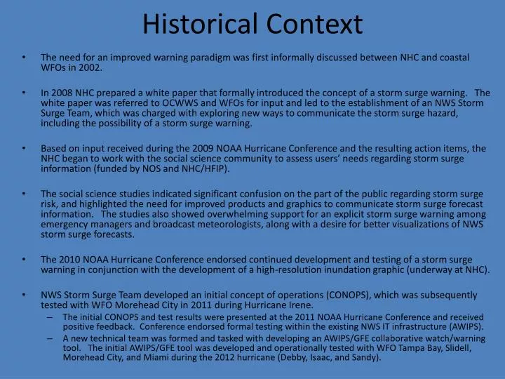
Historical Context • The need for an improved warning paradigm was first informally discussed between NHC and coastal WFOs in 2002. • In 2008 NHC prepared a white paper that formally introduced the concept of a storm surge warning. The white paper was referred to OCWWS and WFOs for input and led to the establishment of an NWS Storm Surge Team, which was charged with exploring new ways to communicate the storm surge hazard, including the possibility of a storm surge warning. • Based on input received during the 2009 NOAA Hurricane Conference and the resulting action items, the NHC began to work with the social science community to assess users’ needs regarding storm surge information (funded by NOS and NHC/HFIP). • The social science studies indicated significant confusion on the part of the public regarding storm surge risk, and highlighted the need for improved products and graphics to communicate storm surge forecast information. The studies also showed overwhelming support for an explicit storm surge warning among emergency managers and broadcast meteorologists, along with a desire for better visualizations of NWS storm surge forecasts. • The 2010 NOAA Hurricane Conference endorsed continued development and testing of a storm surge warning in conjunction with the development of a high-resolution inundation graphic (underway at NHC). • NWS Storm Surge Team developed an initial concept of operations (CONOPS), which was subsequently tested with WFO Morehead City in 2011 during Hurricane Irene. • The initial CONOPS and test results were presented at the 2011 NOAA Hurricane Conference and received positive feedback. Conference endorsed formal testing within the existing NWS IT infrastructure (AWIPS). • A new technical team was formed and tasked with developing an AWIPS/GFE collaborative watch/warning tool. The initial AWIPS/GFE tool was developed and operationally tested with WFO Tampa Bay, Slidell, Morehead City, and Miami during the 2012 hurricane (Debby, Isaac, and Sandy).
Storm Surge Social Science Strategy Decision Support for EMs WxEM – Tropical use case in NC RENCI, UNC-CH, ECU: multiple methods to assess EMs NOS/CSP & CSDL NOS/CSP NWS/OST Assess Public Need Phase 1 (TC) and Phase 2 (ET) Lazo & Morrow: interviews, focus groups, public surveys Assess Partner Needs Phase 3 Lazo & Morrow: media web interviews and online survey NWS/HFIP Product Prototyping and Evaluation Phase 4 (TC): Inundation graphic, Storm Surge watch/warning ERG: prototype evaluations via interviews, focus groups, public surveys Irene Service Assessment UCAR Community Advisory Committee NWS/NCEP Experimental Products 2013-2015 season Inundation graphic, storm surge watch/warning NOS/CSC Marketing and Outreach Integrating new products NWS/NCEP Operational Products 2014-2016 season Inundation graphic, storm surge watch/warning
PARTNER AND USER VIEWS OF A STORM SURGE WARNING • Supported by FEMA Administrator Fugate (conveyed to NHC directors Read and Knabb) • Other government met. services issue Storm Surge Warnings, e.g., Environment Canada • Survey results from coastal counties show overwhelmingly strong support: • Public • 90% support: sample: 700 respondents (2010 NWS survey) • 72% "yes"; sample: 900 Atlantic, Gulf and Pacific coastal residents (Lazo and Morrow 2010) • 92% "yes"; sample: 177 living within 10 miles of coast (Morrow and Nadeau 2012) • Emergency Managers: • 79% "completely agree" (68%) or "agree somewhat" (11%); 53 EMs NC-TX, HI, AK (Lazo and Morrow 2010) • 87% "strongly agree" (50%) or "agree" (37%); 110 Atlantic, Gulf and Pacific EMs (Lazo and Morrow 2012) • Majority support from local EMs and media contacted by SR WFOs and ER WFOs (NWS 2010) • NC: one of two most "fruitful area(s) for consideration" (NC State Deputy EM Director 2011) • Media: • 90% "strongly agree" (69%) or "agree" (21%); sample: 51 local broadcast met’s. (Lazo and Morrow 2012) • Weather Underground endorses (NWS feedback paper 2008) • "I'm totally supportive” (Norcross, The Weather Channel 2012) • Majority support from local EMs and media contacted by SR WFOs and ER WFOs (NWS 2010) • “…the National Hurricane Center's plan was to have a new surge warning system in place by 2015. That was an absurd time frame…” (NOLA.com editorial 2012)
Proposed Next Steps • 2013: • Further refine AWIPS tool based on 2012 results and WFO beta site input • Expand beta sites for 2013 hurricane season • Begin marketing and outreach study to investigate how a storm surge warning integrates into existing NWS product stream • Begin testing/evaluating various dissemination techniques • Evaluate current CONOPs and AWIPs tool within the ET arena • 2014 • Test existing tools/code on AWIPS2 platforms • Integrate planned upgrades to Psurge (tide, upgrade to basins, incremental probabilities, etc) into existing CONOPS/GFE tool for testing and evaluation during 2014 hurricane season • NWS outreach effort to prepare users/partners • 2015 • Experimental or Operational implementation?