Download
1 / 24
240 likes | 438 Vues
The South Broad Street Corridor Plan:. Planning Commission Workshop October 17, 2007 City of San Luis Obispo. Format of Meeting. Brief staff presentation to respond to several issues raised at previous hearing Review Development Capacity analysis

E N D
The South Broad Street Corridor Plan: Planning Commission Workshop October 17, 2007 City of San Luis Obispo
Format of Meeting • Brief staff presentation to respond to several issues raised at previous hearing • Review Development Capacity analysis • Breakout sessions to further discuss 3 topic areas: Circulation, Land Use, and Form-based Codes • Reconvene to feed back information to larger group • Discuss and give direction to staff
Commission Direction • Evaluate development capacity with regard to parking • Restudy land use types and transitions • Restudy street circulation and cul-de-sac street ends • Consider economic implementation tools • Clarify plan organization and how form-based codes would work • Set up special workshop to discuss alternatives
Staff Response • Analyzed development capacity, parking and access for 8-block area • Re-evaluate land use types and location • Reviewed examples of FBCs and identified needed changes for SBSC • Reviewed traffic count results and preliminary existing conditions analysis • Researched and rewrote section on ‘economic tools’
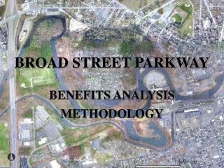
Analysis of Development Capacity • Estimate potential floor area and floor area ratios for an 8-block area of the South Broad Street Corridor Plan (SBSCP) • Evaluate massing model, potential land assembly and vehicle access based on development standards in the draft Plan • Provide a capacity baseline for environmental/traffic analysis • Explore how parking requirements affect achievable floor area ratios (FAR).
Methodology • Defined area of study: focus on center of planning area with oldest development • Described assumptions • Designed a typical block lot layout • Sited buildings and access ways • Applied development standards from draft SBSCP • Land use, FAR, height limits, setbacks, parking requirements. • Provided mixed building types and uses • Allow for cross-block access via alleys and pedestrian paths
Assumptions • Balance parking demand and supply on each block • Reciprocal parking and access easements on each block • Each block has a mix of commercial and residential uses following the draft plan. • Preserve most potentially historic buildings and rehabilitate for commercial uses • Assume 24 ft. wide cross-block access ways • 100 ft. setback for dwellings and 3-story buildings from Broad St. • Graphics reflect capacity estimates and show potential building height, placement, and massing; they do not reflect architectural styles from the draft plan.
Parking • Develop two parking scenarios for each block: • at grade level, covered • at grade plus below grade • 30% mixed-use parking reduction applied to each block • Guest parking provided on street • Parking requirements based on the following ratios: • Commercial / Office: 1 per 300 sq. ft. • Service Commercial (C-S): 1 per 500 sq. ft. • Residential: 1 per studio; 1.5 for first bedroom plus 0.5 spaces for each additional bedroom unit.
Combined Summary Findings * On site parking vehicles only
Summary Findings Estimated number and types of Dwelling Units:
Numbered Block Index Study Area 18 19 20 17 12 13 14 15
Demonstration Block 12A 12 Scenario A: At grade level parking Existing Property Lines Potential Building Area • Commercial / Office, Mixed-use, Live / Work, Retail • Height: 25 ft ● 162 Parking Spaces • Average FAR: 0.93 ● (30) 2 BR Buildings Preserved; Potential Historic Value
Demonstration Block 12B 12 Scenario B: At grade plus below grade level parking Existing Property Lines Potential Building Area Below grade level parking • Commercial / Office, Mixed-use, Live / Work, Retail • Height: 35 ft ● 209 Parking Spaces • Average FAR: 1.10 ● (30) 2 BR and (13) Studios Buildings Preserved; Potential Historic Value
Form-Based Code Discussion • Primary focus on form of streetscape as defined by buildings. Emphasis on building type, dimensions, facades, and parking locations. • Two different formats: transect vs districts, neighborhoods, and corridors – Broad Street Corridor uses the latter • Public participation
Form-Based Codes cont. • Regulating Plan Options - examplesFarmers Branch Texas City of Santa AnaCity of HerculesSalinas • Organization of Plan • Streets and Building types • Funky Character
Land Use Discussion Key Land Use Issues: • Are the proposed land use classifications and general locations appropriate (e.g. “Mixed-Use Neighborhood Commercial)? • What land uses not addressed in Draft Plan should be allowed? • Should new dwellings be allowed adjacent to Broad Street? • Should flexible parking requirements be applied, such as on-street guest parking? • What type of housing is appropriate off Orcutt?
Circulation Discussion Key Circulation Issues: • Should cul-de-sacs be provided at Broad Street? • Should an internal grid network of public or private streets be provided? • How should Bicycle Advisory Committee comments be included? • Identify key pedestrian, bicycle, public transit links and points of connection.
Breakout Session City of San Luis Obispo