Download
1 / 35
370 likes | 380 Vues
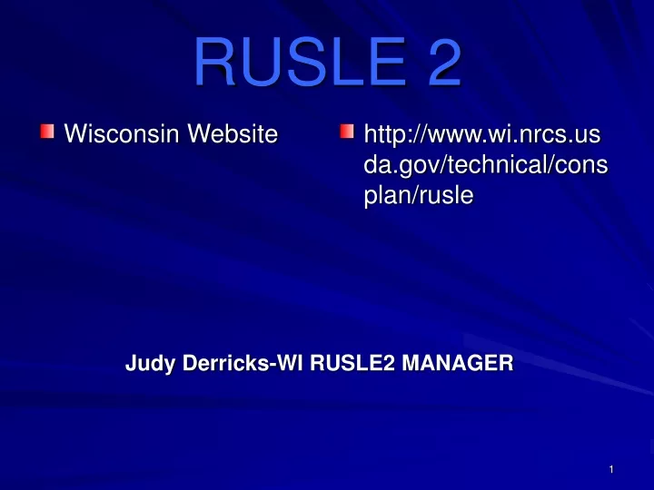
Wisconsin Website. http://www.wi.nrcs.usda.gov/technical/consplan/rusle. RUSLE 2. Judy Derricks-WI RUSLE2 MANAGER. OBJECTIVES. Understand erosion concepts important in RUSLE2 Understanding RUSLE2 updates & installations Understand the RUSLE2 factors affecting erosion rates and soil quality

E N D
Wisconsin Website http://www.wi.nrcs.usda.gov/technical/consplan/rusle RUSLE 2 Judy Derricks-WI RUSLE2 MANAGER
OBJECTIVES • Understand erosion concepts important in RUSLE2 • Understanding RUSLE2 updates & installations • Understand the RUSLE2 factors affecting erosion rates and soil quality • Understand the Application of Erosion Principles to Conservation Planning • Explore Additional Uses and Application for RUSLE2
Beyond…RUSLE 2 Sheet & Rill Only…..No Concentrated Channels
Types of Water Erosion Classic Gully Ephemeral Rill / Interill (Sheet & Rill)
Why Erosion Is a Concern(What are the impacts of erosion?) Produces sediment that carries other pollutants (eg. nutrients, pesticides) Produces sediment which is a pollutant Causes downstream sedimentation Degrades soil resource 1. Reduces soil productivity 2. Reduces soil O. M. 3. Removes plant nutrients
Erosion Contributing Factors? Climate (R) Soil (K) Topography (LS) Crops (C ) - Management Supporting Practices (P)
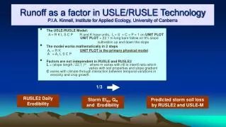
Erosion Factors – Climate Different geographic areas have different climates. Each climate has a unique pattern of rainfall and storm intensity. The influences of storm energy and volume of water combine to detach soil and transport it.
Las Vegas, NV 8 Phoenix, AZ 22 Denver, CO 40 Syracuse, NY 80 Minneapolis, MN 110 Chicago, IL 140 Ashland 100 Dodge 130 Manitowoc 110 Richland 140 Rock 150 Erosion Factors - Climate, Erosivity - R A measure of erosivity of climate at specific locations
Erosion Factors -Soil, Erodibility - K • During mapping, soils are assigned an erodibility factor based on their inherent potential to erode. • Soil erodibility factors assigned to soils usually range from values of 0.17 to 0.60. Organics can be as low as .02. • The higher the erodibility factor, the greater the inherent potential to erode.
Erosion Factors - Soil, Erodibility - K, Variable over Time • Varies during year • High when rainfall is high • Low when temperature is high • Very low below about 25 oF
Erosion Factors - Soil Tolerance to ErosionThe “T” Value • Different soils have different tolerances to erosion. • Soil scientists assign a soil loss tolerance “T” value to soil during mapping based on the soil’s properties and potential for the soil to lose productivity over time from erosion. • T values assigned to soils during mapping are 1, 2, 3, 4, or 5 tons per acre per year. • Soils with lower T values are much more quickly damaged from erosion than soil with higher T values.
Erosion Factors - Topography “The Planning L” Overland flow slope length Soil loss Remote deposition “L” Sediment yield Soil Loss for Planning Complex Slope – Convex/Concave
Cover-Management Effects Raindrops intercepted by canopy cover Raindrops not intercepted by canopy cover Canopy cover Ground cover Ridges Random roughness Buried residue Soil consolidation Live roots Dead roots
The presence or absence of crop canopy or crop residue is one of the most important factors determining whether erosion will actually occur, even during periods of high EI. Management – “C” Factors
Erosion FactorsCover Management Subfactors(Effect of Below Ground Biomass) • Roots mechanically hold the soil • Add organic matter that improves soil quality, reduces erodibility, increases infiltration • Affect rill erosion more than interrill erosion • Effect of buried residue over upper 3 inches, but depth decreases to 1 inch as soil consolidates (e.g. no-till)
Erosion FactorsCover Management Subfactors(Soil Consolidation) • Overall, freshly tilled soil is about twice as erodible as a fully consolidated soil. • Erodibility decreases with time > 6 years in Wisconsin
Supporting Practices Contour Stripcropping Contouring Contour Buffer Strips Terraces
Supporting Practices(Contour Farming) • Redirects surface runoff • Effectiveness is determined by ridge height (no ridge height = no contour effect). • Effect is greatest when rows are aligned on the true contour. • Fails on long slope lengths.
Supporting Practices(Contour Stripcropping) • Usually equal width strips. • Crops in the strips are rotated through a rotation cycle. • Crops are offset so that strips of close growing crops (small grain, perennial crop) separate strips with more erodible crops row crops (corn, soybeans)
Erosion PredictionConservation Planning Data Needed • Locate the “Significant Planning Area” for the field. • Length and Steepness of Slopes. • Crops grown and sequence of crops. • Field Specific Crop Yields. • Soil types. • Supporting Practices (where appropriate).
Significant “Planning Area” 8% @ 200 ft. 20% Area 6% @ 200 ft. 25% of area 4% @ 250 ft 40% Area 5% @ 250 ft 15% of Area
KEY CONCEPTS • Soil Condition Index (SCI) • Soil Tillage Intensity Rating (STIR) • Energy Calculator • Residue Levels (FLAT RESIDUE)
Soil Condition Index • Rotation—OM returned to the soil • Field Operations—Type, speed & number of passes • Erosion Factors • THE HIGHER THE NUMBER THE BETTER!! • “0” Means OM is being maintained (The numbers range from -2..0..+2)
ROTATION IS CRITICAL • OM • Canopy Cover • Residue composition
HOW CAN I IMPACT SCI?? • High residue crops in rotation • Cover crops where it matters • Mulch & Manure applications • Reduce the tillage • Reduce the soil disturbance • Minimize the erosion from wind & water • Increase crop production/residue levels
STIR (Soil Tillage Intensity Rating) • Operating speed • Tillage type—mechanical disturbance • Tillage Depth-Residue incorporation • Surface area disturbed as related to consolidation STIR VALUE=0-200 LOW NUMBER IS GOOD Prefer under 30
Improve STIR Value…….. • Reduce tillage • No Tillage Systems • Soil Conserving Crops such as Alfalfa/Grass
Most Common Errors • Don’t Capture Enough Information • Changing Yields & Residue Levels • Not Reviewing Soil Condition Index With Landowners • Using Profiles and not keeping common runs under worksheet • Not Using Manure Correctly • WI First 3 Went Away…Keep Current! • Not Using those Yellow Folders Enough
Set up Template for county and common soil & Save as “Dane” Change Column Widths Add several Profiles
Start Here! Add uniqueness Last Step Once & Label Put in notes