Download
1 / 20
210 likes | 374 Vues
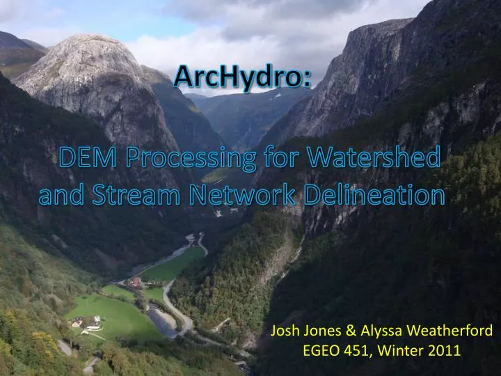
ArcHydro : DEM Processing for Watershed and Stream Network Delineation. Josh Jones & Alyssa Weatherford EGEO 451, Winter 2011. WHY?.

E N D
ArcHydro: DEM Processing for Watershed and Stream Network Delineation Josh Jones & Alyssa Weatherford EGEO 451, Winter 2011
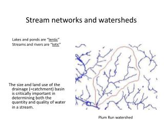
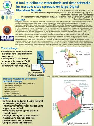
WHY? ArcHydro is used mainly by hydrologists or GIS professionals interested/working in the field of water resources. Even if you are not directly interested in water resources, it is at least beneficial to know some basic processes within a very powerful and extensive set of tools. Watershed analysis is used by many others because of how dependent humans and animals are on water. If a watershed becomes contaminated many problems can arise because of this watershed conservation is a big deal. This presentation outlines the necessary steps to develop stream network flow in regards to a Digital Elevation Model.
Step 1: Set Processing Output Locations Within the ArcHydro toolbar, ApUtilities allows you to set the output locations for the numerous files that will be created by the end of the exercise. Raster data can go in any file, but the vector data must have a Geodatabase as the output location.
Step 2: Import a DEM and Hydrology for Study Area. DEM: J:\GEO\GEO_data\WA_USGS\DEM_10_MOSAICS\Bham_Whatcom_Co\w_wc_dem Hydrology: USGS, National Hydrography Dataset, http://nhd.usgs.gov/
Step 3: Dem Reconditioning This step creates linear features between the raw DEM and the hydrography layer, which is needed to develop flow on the stream network.
Step 4: Fill DEM Sinks In a DEM there can be sinks or artificial ponds that are not present on the surface of the earth. This tool will smooth the DEM and eliminate these sinks.
Step 5: Flow Direction Based upon the DEM conditioning, this action will now assign flow direction to the surface of the DEM. Each pixel in the resulting DEM is assigned a direction of the path of steepest descent. Each number, although seemingly nonsensical values have been chosen, represents a direction. 1=E, 2=SE, 8=S, etc.
Step 6: Flow Accumulation For a stream network, calculations are made to figure out how many flow cells are upstream from each individual stream cell. Calculates the entirety of a system, computing the amount of flow that accumulates over the life of a stream network. Lower amounts at the headwaters, higher numbers nearer the pour point. Darker means higher flow accumulation.
Step 7: Stream Definition Creates a stream grid, assigning values of “stream” to cells that are within the flow accumulation network, and “no data” to any cells outside of the flow accumulation network. Same image as Flow Accumulation, but no magnitudes are assigned to pixels, simply stream/no stream.
Step 8: Stream Segmentation Defines portions of the stream network as either head segments, intermediate segments, or terminal segments.
Step 9: Catchment Grid Delineation Creates a raster layer that delineates the individual watersheds. Each watershed is assigned a value that corresponds to the values for the stream that drains the particular watershed.
Step 10: Catchment Polygon Processing Converts the Catchment Grid raster to a Catchment Polygon vector data set.
Step 11: Drainage Line Processing Converts the Stream Link Grid raster data set to the Drainage Line feature dataset and assigns an individual value to each segment based upon which catchment grid it resides within. Drainage Lines, usually located on higher order streams or on high topography
Step 12: Adjoint Catchment Processing Uses the catchment feature class to generate the set of aggregated upstream catchments from the drainage points. A polygon representing the adjoint catchments.
Step 13: Drainage Point Processing Generates the drainage points for each individual catchment from the previous Catchment Processing operations.
Problems • Watershed delineation did not always reflect the watersheds in their true form. Lake Whatcom was showed draining out of a channel in the Northeast instead of through Whatcom Creek at first. • After trying numerous DEM’s and different stream networks, it did finally show the correct drainage path. • This type of analysis is very picky, when you think you barely changed something it ends up not doing the analysis correctly.
Whatcom Watershed • There are two groups of people, one who want to develop the watershed and other who want to make the Whatcom watershed DNR land. • The Whatcom watershed is the main drinking water source for over 95,000 people. • Development and allowing to log can lead to contamination of water and landslides due to the areas steep slopes and high rain fall.
DEMO By Josh Jones
The End QUESTIONS?
Sources: • VaddeySesgu & Harman, Rhett. Basics of Arc Hydro: Building a New Foundation for Water Resources • USGS • Conservation Northwest. Next Step for a Whatcom watershed Preserve. November 9, 2009. http://www.conservationnw.org/oldgrowth/whatcom-county-council-approves-next-step-in-creating-the-lake-whatcom-forest-preserve. Retrieved Feburary 28, 2011 • For more Whatcom Watershed Information • About Our Drinking Water • http://lakewhatcom.whatcomcounty.org/http://www.ecy.wa.gov/biblio/99337.html • About Development • http://www.co.whatcom.wa.us/publicworks/water/lakewhatcom.jsp • About Conservation • http://www.conservationnw.org/oldgrowth/whatcom-county-council-approves-next-step-in-creating-the-lake-whatcom-forest-preserve • http://www.lakewhatcom.whatcomcounty.org/asub_fldrs/about_us/program_areas/land_preservation.shtml