Download

1 / 13
130 likes | 237 Vues
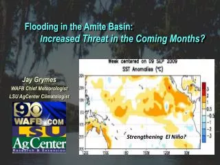
Flooding in the Amite Basin: I ncreased Threat in the Coming Months?. Jay Grymes WAFB Chief Meteorologist LSU AgCenter Climatologist. Strengthening El Niño?. Flooding in the Amite Basin: I ncreased Threat in the Coming Months?.

E N D
Flooding in the Amite Basin: Increased Threat in the Coming Months? Jay Grymes WAFB Chief Meteorologist LSU AgCenter Climatologist Strengthening El Niño?
Flooding in the Amite Basin: Increased Threat in the Coming Months? -- reviewed daily mean stage for ‘Amite nr Denham Springs’ for the period Oct 1974 – present . . . data courtesy of USGS, Louisiana -- “flood events” defined as at least one day with daily mean stage ≥ 29.0 ft -- “moderate flood” defined as at least one day with daily mean stage ≥ 35.0 ft -- “major flood” defined as instantaneous stage ≥ 39.0 ft
Nov-to-Mar Rainfall: Departure from Normal El Nino Winter/Springs: 1950 - 1995 Rainfall Below Normal Rainfall Above Normal
El Niño ‘Signature’ along the Gulf Coast: ‘Active’ Sub-Tropical Jet Sub-Tropical Jet More Frequent Gulf Lows “Warm” SSTs
December-thru-May Rainfall: Louisiana EC Climate Division 1974-75 thru 2009-10 El Niño La Nada “Neutral” El Niño/Southern Oscillation (ENSO) Ranking La Niña Series Median 6-mo. Rainfall (in.) Seasonal rainfall tends to be greater during El Niño events Rainfall Data: NOAA/National Climatic Data Center ENSO Ranks: NOAA/NWS Climate Prediction Center
Amite River near Denham Springs Flood Events: Oct 1974 – Present by Month 51 Events -- 4 as ‘tropical’ -- 3 in summer/fall ‘Babe’ (1977) ‘Juan’ (1985) ‘Allison’ (2001) ‘Gustav’ (2008) River Stage Data: USGS, Louisiana
Amite River near Denham Springs Flood Events: Oct 1974 – Present by Month 51 Events Apr 1977 & Apr 1983 . . . ‘major’ floods . . . both during El Niños 1983 1977 1990 ‘Major’ Floods: > 39 ft River Stage Data: USGS, Louisiana
Amite River near Denham Springs Flood Events by Year: 1974 – Present (All Months) River Stage Data: USGS, Louisiana
Amite River near Denham Springs Flood Events by Year: 1974 – Present (December thru May) ‘Major’ Floods: > 39 ft River Stage Data: USGS, Louisiana
NWS/CPC ENSO ONI Index: Jan-Feb-Mar Index Score 35 Seasons: 9 El Niños & 9 La Niñas El Niño La Niña ONI Index: NWS Climate Prediction Center
NWS/CPC ENSO ONI Index: Jan-Feb-Mar Index Score & Occurrences of Winter/Spring Floods 5 El Niños: 16 floods in 9 seasons 1 El Niño 1 2 3 1 1 0 2 La Niñas: 5 floods in 9 seasons 0 1 1 0 0 1 0 0 2 La Niña No ‘moderate’ to ‘major’ floods La Nadas: 23 floods in 17 seasons ONI Index: NWS Climate Prediction Center
Flooding in the Amite Basin: Increased Threat in the Coming Months? While flooding in the coming months is not a certainty, climatic signals (El Niño) point to an elevated threat of ‘high water’ along the Amite near Denham Springs . . . and therefore much of the greater Amite Basin.