Download
1 / 4
50 likes | 319 Vues
GTOPO30 Global 30-arc-second (1-km) elevation model. “ Best available” global DEM. Initial release: March 1997. Widely used for climate modeling, land cover characterization, hydrologic modeling, and EOS satellite image product generation.

E N D
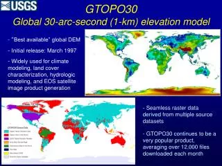
GTOPO30Global 30-arc-second (1-km) elevation model • “Best available” global DEM • Initial release: March 1997 • Widely used for climate modeling, land cover characterization, hydrologic modeling, and EOS satellite image product generation • Seamless raster data derived from multiple source datasets • GTOPO30 continues to be a very popular product, averaging over 12,000 files downloaded each month
The National Elevation Dataset (NED) • Seamless national coverage of “best available” raster elevation data • Geographic “projection” • 1-arc-second (30-meter), 1/3-arc-second (10-meter), and 1/9-arc-second (3-meter) grid spacing • Alaska: 2-arc-second grid spacing • Datum: NAD 83 horizontal; NAVD 88 vertical • Elevation units: decimal meters • Updated bi-monthly to incorporate all new USGS DEM production and other newly available source data • NED is the elevation layer of The National Map
Source Data Resolution 3 meters or better (3%) 10 meters or better (67%) 30 meters (30 %) National Elevation Dataset: Source Data April 2007 release: over 70% 10-meter DEM source or better