Download
1 / 21
250 likes | 409 Vues
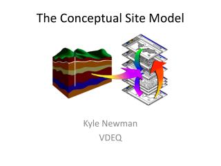
THE CONCEPTUAL SITE MODEL A Visual Journey Though Data and Time. October 29, 2013. Conceptual Site Model _. WHAT IS A CONCEPTUAL SITE MODEL ?. Conceptual Site Model _.

E N D
THE CONCEPTUAL SITE MODELA Visual Journey Though Data and Time October 29, 2013
Conceptual Site Model _ WHAT IS A CONCEPTUAL SITE MODEL ?
Conceptual Site Model _ A Conceptual Site Model (CSM) describes site features and surface/subsurface conditions to understand contaminants and the risk(s) they pose to receptors.
Conceptual Site Model _ A CSM is included in the Part 213 definition of RBCA which directly references the ASTM: Standard guide for development of conceptual site models and remediation strategies for light nonaqueous-phase liquids released to the subsurface, designation E 2531-06 E1, which references the Standard guide for development of conceptual site models for Contaminated Sites, designation E 1689-95 (Reapproved 2008), which states (paraphrased): A CSM is a written or pictorial representation of an environmental system and the processes that determine transport of contaminants from sources to receptors.
Conceptual Site Model _ A CSM describes site conditions by: Identifying sources, pathways and receptors for contamination. Identifying critical biological, chemical or physical processes. Identifying the presence (and absence) of contamination.
Conceptual Site Model _ The CSM is an EVOLVING document.
Conceptual Site Model _ DEVELOPMENT OF A CONCEPTUAL SITE MODEL
Conceptual Site Model _ Scope Summary Sources Pathways and Receptors Narrative and Visual Description
Conceptual Site Model_ Scope of the Conceptual Site Model What Needs to be Characterized Extent of Area to be Investigated Human and/or Ecological Receptors Contaminants of Concern (COCs) Applicable Remedial Criteria Immediate/Long Term Environmental Concerns
Conceptual Site Model _ 2. Summarize Available Information Property Description Historical Information Off-site and Regional Information Geologic and Hydrogeological Information Other
Conceptual Site Model _ Identify and Characterize Sources Operational and Ownership History Current and Historic Releases Location and Content of Releases Extent/Volume/Mass Prior Remedial Actions
Conceptual Site Model _ 4. Identify Pathways and Receptors - Exposure Pathways Current Potential Future Use - Human and/or Ecological Receptors
Conceptual Site Model _ 4. Identify Pathways and Receptors
Conceptual Site Model _ 5. A Narrative and Visual Description Puts all the pieces together in a summary fashion for the site as it is understood at that time. The CSM should describe the site, contaminants, pathways, and receptors. More complex sites should include a discussion of data gaps or uncertainties. Note: this is probably the most critical part of a CSM. You need to be able to provide a clear description of your model and graphics with an explanation are a great way to do this.
Conceptual Site Model _ LET THE FUN BEGIN…
Conceptual Site Model _ The Narrative: A release of NAPL occurred from a dispenser. That NAPL migrated into the subsurface and migrated along a clay layer at 10 feet and then entered an aquifer 30 feet west of the source. The NAPL then pancaked in a classical fashion and created a groundwater plume that is migrating to the NE. That plume included BTEX at levels representative of a NAPL source and has migrated 260 feet down-gradient. The source area presents a VI risk but soil vapor data indicate that the risk is contained and has not reached any structures. Down-gradient drinking wells are in the path of migration of the dissolved phase…
Conceptual Site Model _ Contact Information Joseph DeGrazia, C.P.G. Senior Geologist Michigan Department on Environmental Quality Remediation and Redevelopment Division Southeast Michigan District Office (586) 753-3812 degraziaj@michigan.gov