Download
1 / 17
170 likes | 317 Vues
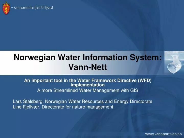
Norwegian Water Information System: Vann-Nett. An important tool in the Water Framework Directive (WFD) implementation A more Streamlined Water Management with GIS Lars Stalsberg, Norwegian Water Resources and Energy Directorate Line Fjellvær, Directorate for nature management.

E N D
Norwegian Water Information System: Vann-Nett An important tool in the Water Framework Directive (WFD) implementation A more Streamlined Water Management with GIS Lars Stalsberg, Norwegian Water Resources and Energy Directorate Line Fjellvær, Directorate for nature management
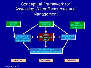
GIS in the Water Framework Directive • Implementation of The Water Framework Directive (WFD) (2000/60/EC) initiated the development of a Norwegian GIS based Water Information System (Vann-Nett) to able to: • implement the directive • delineate water bodies (WB) • add attributes to the WB • present the data for the public • Report the data to ESA/EU • Handle a large number of geographical data (today 16400 WBs) • Easy access to the WB which needs updating • Easy access for all users to retrieve data on an object • Easy to create statistics and maps for reports and the public
What is Vann-Nett? • Vann-Nett consists of three different applications • Vann-Nett Saksbehandler for executives who maintain WFD data (can be viewed by all stakeholders) • Vann-Nett Innsyn which is created for all stakeholders who need easy access to WFD data • Map • Statistics • Photos of WBs • Vann-Nett Rapport which is a temporary application for fetching reports on all administrative levels • Users ask for new reports which will be created in Crystal Reports as templates • Vann-Nett both a Norwegian and an English version
Why ArcGIS Server in the WFD work? • Our reasons for using an ArcGIS Server (AGS) and a multi-user ArcSDE database for Vann-Nett are that; • All users work via the Internet in the same interface • All users add data to the same central database (Oracle) • All users can see all data in real time • All users have got access to the same thematic datasets • All users have access to templates for reports/statistics/maps • Easy to centrally administer users, data and application • Easy to add new data and templates to the users via the application • Possible to hook up with other AGS, such as SFTs Vannmiljøsystem to fetch data in real time! • In the future hook up to other AGS
The WFD data input Vann-Nett • The users create new WB and update existing ones via the map interface or by using search engine
The WFD data output Vann-Nett • Vann-Nett Public is used for data output on all administrative levels (Municipalities, counties, RBDA, Country) and for WBs • Statistics on status and risk evaluation • Statistics on different pressure, quality elements etc • Detailed data on each WB
Thematic data • No WMS for thematic data yet, because; • Thematic data via WMS has a long response time in AGS • When a server is down, response time even longer • Not always a good legend for the data in the TOC • This might be improved in AGS 9.3, but still a little early to see how this works in practice • But, Vann-Nett has a service where users can add WMS locally! • So, in Vann-Nett we use locally stored data (still) • Gives good response time, but no updates from owners (of course, manual updates are no good solution) • Geocache for vector and orthophoto works very fast and parks WMS totally • Users are very concerned about response time • As time and money allows we will look into new ways of displaying thematic data in Vann-Nett
Who is using Vann-Nett? • Users of the Vann-Nett applications are (and will be): • Executive personnel administering the WBs and the data • Ministries and directorates • Municipalities • Press • The public • Eurostat, EEA, ESA and the EU • NGOs and other organizations
The future development of Norwegian Water Information System (2009) • Streamlining of database to be fully compatible with SEIS - WISE and reporting • Access to all documents and plans relevant for the WFD work fetched via Web-service • Connecting Vann-Nett and Vannmiljøsystemet (Water Environmental System) will be connected • And more……
Conclusion • Norwegian Water Information System improves water management because; • All data in one place/accessible for all stakeholders • Better coordination between authorities • Easier reporting to WISE (SEIS) • Data always updated • No copying and sending needed • Map interface makes it easy to find data (especially when all plans are connected to WBs) • Can be used from anywhere via Internet • More interesting presentation of data for the public and the press • In short, a more fluent and improved water management is possible with GIS and Vann-Nett
Feel free to test these links • Executive version: http://vann-nett.nve.no/vann-nett • Public version: http://vann-nett.nve.no • Reports in Norwegian: http://vann-nett.nve.no/rapport • Thank you for your attention