Download
1 / 14
140 likes | 219 Vues
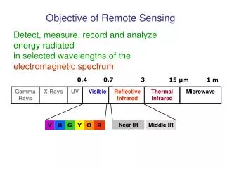
Landscape Heterogeneity of Riverine Wetlands of the Amazon Basin from a Remote Sensing Perspective. UCSB – INPE - UW Leal A.K. Mertes Evlyn Novo Yosio Shimabukuro Thelma Krug Jeffrey Richey Funding - NASA & W. Alton Jones Foundation. OUTLINE.

E N D
Landscape Heterogeneity of Riverine Wetlands of the Amazon Basin from a Remote Sensing Perspective UCSB – INPE - UW Leal A.K. Mertes Evlyn Novo Yosio Shimabukuro Thelma Krug Jeffrey Richey Funding - NASA & W. Alton Jones Foundation
OUTLINE • Relationships among floodplain morphology, vegetation distribution, and inundation hydrology. • Floodplain morphology and inundation hydrology 1. along mainstem Amazon River 2. across Amazon Basin. • Classification procedure for optical data. • Trends in spatial patterns of Amazon Basin wetlands
Amazon Basin Hydrology(based on unpublished data provided by Dunne & Newton) Averages based on data for 1972-1996 Average total rainfall - mm Coefficient of variation (by month)
Vegetation Zonation on Amazon River Wetlands low water (After Junk 1970)
macrophyte Classification of SMA Data clear water shade/clear turbid vegetation forest t turbid water v sh classified senesced/bare color composite
c a b FOREST I (LO DENSITY) FOREST II (HI DENSITY) MACROPHYTE I/ PASTURE (HI DENSITY) MACROPHYTE II/PASTURE (LO DENSITY) TURBID WATER CLEAR WATER CLEARWATER W/LOW VEGETATION SENESCED OR DEFOLIATED VEGETATION UNCLASSIFIED MUDDY PASTURE/MACROPHYTE BOTTOM REFLECTANCE SAND BARS URBAN/BARE PASTURE b a c
Vegetation Zonation on Amazon River Wetlands low water (After Junk 1970)
Amazon Mainstem Floodplain - Areal (km2) & Percent Cover • 30567 lo trees 8776 hi trees11610 lo macro 3328 hi macro 7595 clear17951 turbid 1010 lo veg 2708 dry veg 6383 pasture 173 sand bar • 90,275 all • 64,383 just veg25,546 just water
4 1 3 2 Summary for Mainstem • Landform and vegetation heterogeneity is most diverse in Zones 2 & 3 where there is significant mixing of river water and floodplain water during high water. Floodplain landforms available for colonization by vegetation include scroll bars, swales, lake shores, lake deltas, and floodplain drainage channels. • Zones 1 & 4 have less heterogeneous vegetation cover. However, where landforms are similar to the middle reaches, the spatial distribution of vegetation is similar. • Decreased forest cover downstream result of marked seasonality of precipitation and longer history of forest cutting.