Download
1 / 1
10 likes | 137 Vues
10B. 14A. Spatial and temporal free-ranging cow behavior pre and post-weaning D.M. Anderson 1 , C. Winters 1 , M. Doniec 2 , C. Detweiler 2 , D. Rus 2 , and B. Nolen 1

E N D
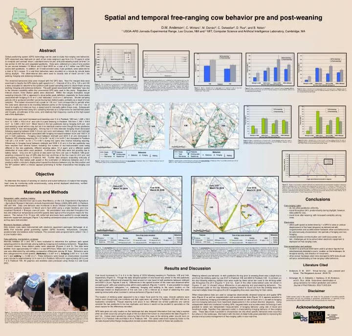
10B 14A Spatial and temporal free-ranging cow behavior pre and post-weaning D.M. Anderson1, C. Winters1, M. Doniec2, C. Detweiler2, D. Rus2, and B. Nolen1 1 USDA-ARS Jornada Experimental Range, Las Cruces, NM and 2 MIT, Computer Science and Artificial Intelligence Laboratory, Cambridge, MA Abstract Global positioning system (GPS) technology can be used to study free-ranging cow behaviors. GPS equipment was deployed on each of ten cows ranging in age from 3 to 15 years in order to compare and contrast mean ± standard errors for pre- and post-weaning travel (m∙time-1) in two similar (≤ 433 ha) arid rangeland paddocks. Data were collected at a rate of one position fix per second between 12 March and 8 April 2009 for a total of 8.7 million raw GPS fixes across both paddocks. In addition, all 10 instrumented cows, 5 per paddock, were observed for a total of 32 h across 13 d and their behaviors were recorded on a minute by minute basis during daylight. The observational data were used to classify rate of travel (m∙min-1) into walking, foraging and stationary behaviors. The observed behavioral data were merged with the GPS data. Next the merged data were examined to classify the GPS data by path speed (m∙s-1). Intervals of 30 s, 60 s, 120 s and 180 s were evaluated to determine the optimum path speed sampling period to discriminate among walking, foraging and stationary behavior. The path speed associated with “stationary” was due to the inherent variability within the uncorrected GPS data used in this study. Regardless of interval chosen, three distinct peaks were observed. Within the ranges evaluated, longer sampling intervals (180 s) appeared to show better peak definition, especially for those peaks associated with foraging (0.10 m∙s-1) and “stationary” (0.03 m∙s-1) behaviors. Shorter sampling periods (30 s) produced smother curves having less distinct peaks, probably as a result of more samples. The fastest movement had a peak at 1.00 m∙s-1and corresponded to periods when the cows were observed to be traveling between points on the landscape. A 1.00 m∙s-1 rate of travel is roughly 2.2 miles per hour, a speed used to manually gather these cows. Subsequent analyses were performed using 60 s sampling intervals as a compromise for well defined peaks and troughs, smoothness of the curve, and relatively high frequency counts at the high speed end of the distribution. Overall, mean cow travel increased post-weaning over 5 d in Paddock 10B from 1,428 ± 92.6 m∙d-1 to 1,955 ± 143.4m∙d-1 and over 8 d post-weaning in Paddock 14A from 1,166 ± 105.8m∙d-1 to 1,509 ± 92.0m∙d-1. Mean travel in the two paddocks during foraging both pre- and post-weaning varied within a day but not in an identical manner even though the two paddocks were similar in size and topography. Among four 6 h time intervals foraging travel decreased following weaning between 0600 h (6 am) and noon and between 1800 h (6 pm) and midnight in both paddocks while travel associated with foraging increased between noon and 1800 h (6 pm) in both paddocks. Foraging travel between midnight and 0600 h (6 am) decreased in Paddock 10B following weaning (64 ± 5.6 m∙6h-1 vs 42 ± 4.4 m∙6h-1) but increased in Paddock 14A (24 ± 6.6 m∙6h-1 vs 60 ± 7.3 m∙6h-1) during this same time interval following weaning. Differences in foraging travel between midnight and 0600 h (6 am) in the two paddocks may have resulted from several factors including: the number of non-instrumented cows being different in the two paddocks, different weaning dates 13 d apart, and a different spatial distribution of cows within each paddock. Furthermore, GPS data were lost possibly due to battery failure. Only one 24 h period of data were lost from one cow in Paddock 10B (post-weaning) compared to loss of GPS data from two and three of the five cows for 24 h pre- and post-weaning, respectively, in Paddock 14A. Further data analysis evaluating tortuosity of travel (a metric that relates path speed or the summation of distances between each of 60 positions within a minute to displacement speed the distance between only the first position and the 60th position within a minute) appears promising to further characterize free-ranging cow travel. Figure 3. Range in path speeds (m∙s-1) obtained from GPS devices worn by free ranging cows programmed to record fixes at 1 s intervals between 13 March and 7 April 2009 on each of five cows over 6 d during 12 h in Paddock 10B and on each of five cows over 7 d during 20 h in Paddock 14A on the Jornada Experimental Range. To categorize the GPS data into: stationary, foraging and walking behaviors, observations were manually recorded at I min intervals during these identical times. Approximately 35% of the walking among these 10 cows took place at a speed between 0.92 m∙s-1 and 1.10 m∙s-1. Figure 2. Plot of frequency of occurrence of cow 6034’s path speed (m∙s-1) determined by summing the displacement of 1 s global positioning system (GPS) fixes and dividing these displacements in meters by the sample length in seconds. Sample binning is geometric and starts at 0.10 m∙s-1 with a multiple of 1.1. Figure 4. Mean ± standard error of total travel (m∙d-1) among 5 cows on two arid rangeland paddocks ≤ 433 ha on the Jornada Experimental Range between 13 March and 7 April, 2009. Figure 5. Mean ± standard error of total travel (m∙6h-1) among 5 cows in Paddock 10B pre- and post-weaning during each of four 6 h intervals between 13 and 22 March, 2009 on the Jornada Experimental Range. Figure 6. Mean ± standard error of total travel (m∙6h-1) among 5 cows in Paddock 14A pre- and post-weaning during each of four 6 h intervals between 27 March and 7 April, 2009 on the Jornada Experimental Range. 10B 14A Figure 10. Mean ± standard error of travel (m∙6h-1) during foraging among five cows in Paddock 14A pre- and post-weaning during each of four 6 h intervals between 27 March and 7 April, 2009 on the Jornada Experimental Range. Figure 9. Mean ± standard error of travel (m∙6h-1) during foraging among five cows in Paddock 10B pre- and post-weaning during each of four 6 h intervals between 13 and 22 March, 2009 on the Jornada Experimental Range. Figure 8. Spatial location of three behaviors among 5 cows post-weaning in Paddocks 10B (17 to 22 March,2009) and 14A (30 March to 7 April, 2009) on the Jornada Experimental Range. Figure 7. Spatial location of three behaviors among 5 cows pre-weaning in Paddocks 10B (13 to 17 March,2009) and 14A (27 to 30 March, 2009) on the Jornada Experimental Range. Objective To determine the impact of weaning on inactive and active behaviors of mature free-ranging beef cows by monitoring cattle autonomously, using animal deployed electronics, verified with manual observations. Figure 13. Range in neck angles in degrees obtained from magnetometer and accelerometer hardware in electronic equipment packages worn by free ranging cows programmed to record every 0.1 s between 13 March and 7 April 2009 on each of five cows over 6 d during 12 h in Paddock 10B and on each of five cows over 7 d during 20 h in Paddock 14A on the Jornada Experimental Range. To categorize the GPS data into: stationary, foraging and walking behaviors, observations were manually recorded at I min intervals during these identical times. When walking, the 10 cows kept their necks between -5o and 0o approximately 17% of the time. Cow 3039 March 29, 2009 Cow 4127 March 18, 2009 Cow 4127 March 16, 2009 Cow 3039 March 31, 2009 Materials and Methods Rangeland, cattle, weather, training The study was conducted near Las Cruces, New Mexico, on the U.S. Department of Agriculture – Agricultural Research Service’s Jornada Experimental Range (USDA-ARS-JER) in Paddock 10B and 14A. Daily cow behavior was monitored in brush infested Chihuahuan Semidesert Grassland paddocks between 12 March and 8 April 2009 using a single Hereford, and nine crossbred Hereford x Brangus cow-calf pairs. No precipitation was recorded throughout the trial and ambient air temperatures and wind speeds were typical of the long-term means for this season. The mature (3 to 15 year old) cattle had previously been gentled to accept wearing electronic equipment packages (Figure 1) by feeding cottonseed cubes to each cow individually as they were instrumented. Electronic hardware, software Only mature cows were instrumented with electronic equipment packages (Schwager et al. 2008) that included global positioning system (GPS) receivers, temperature, compass, accelerometer and wireless radio hardware. The receivers were programmed to collect 1 Hz (1 s) cow location data. Data gathering, manipulation, analyses Intervals between 30 s and 180 s were evaluated to determine the optimum path speed sampling period to discriminate among walking, foraging and stationary behaviors. Regardless of interval chosen, three distinct peaks were observed (Figures 2 and 3). The data were distilled from approximately 8.7 million 1 s raw GPS fixes. Mean rate of travel (m∙s-1) for each cow was determined by calculating consecutive differences among 60 fixes. Behaviors were then categorized into travel speeds: Stationary (< 0.057 m∙s-1), foraging (0.057 m∙s-1 to 0.382 m∙s-1) and walking ( > 0.382 m∙s-1). These behaviors were based on observations recorded every minute for approximately 12 hr over 6 d in Paddock 10B and for approximately 20 hr over 7 d in Paddock 14A. All graphics and statistics were produced using ArcGis 9.3 and Excel 2003. • Conclusions • Free-ranging cattle: • do not utilize paddocks uniformly. • travel throughout 24 h, predominantly during daylight; however, • daily patterns vary. • travel more after weaning, with increased variability among • cows. • Electronics: • either path speed as determined by 1 s GPS fix rates or vertical displacement of the head (degrees) as determined with magnetometer and accelerometer hardware allow cow behaviors to be autonomously characterized into periods of foraging and non-foraging. • reliable wireless communication and continuous power are • two challenges yet to be solved when electronic equipment is • deployed on free-ranging cows. • Data presentation and analysis: • ArcGIS 9.3 and Excel 2003 were used to produce figures that simultaneously depicted a cow’s location on the landscape, its temporal activity, and direction of movement. • other sensor hardware when time-stamped to GPS data should enhance understanding of free-ranging cattle behaviors. 14A 10B 14A 10B Figure 11. The pre-weaningspatial and temporal behavior and direction of movement of two cows the day before weaning in Paddocks 10B and 14A on the Jornada Experimental Range. These data were determined from 1 s global positioning system (GPS) data obtained from battery/solar powered electronic equipment worn by each animal. Stationary (< 0.057 m∙s-1), foraging (0.057 (m∙s-1) to 0.382 (m∙s-1) , and walking (> 0.382 (m∙s-1) travel speeds were determined by observing and recording the behavior of these two cows and eight others minute by minute for approximately 32 h across 13 d. The observational data were used to characterize the displacement rate of consecutive 1 s global positioning system (GPS) fixes. The three daily behaviors were further characterized as occurring during specific times related to the sun’s angle above the horizon: Morning (solar elevation -12o to 45o rising, ≈ 0604 h to 1042 h), midday (solar elevation 45o rising to 40o setting, ≈ 1043 h to 1607 h), evening (solar elevation 40o to -12o setting, ≈ 1608 h to 2019 h), and night (solar elevation < -12o no sun, ≈ 2020 h to 0603 h). Figure 12. The post-weaning spatial and temporal behavior and direction of movement of two cows the day after weaning in Paddocks 10B and 14A on the Jornada Experimental Range. These data were determined from 1 s global positioning system (GPS) data obtained from battery/solar powered electronic equipment worn by each animal. Stationary (< 0.057 (m∙s-1) , foraging (0.057 (m∙s-1) to 0.382 (m∙s-1) , and walking (> 0.382 (m∙s-1) travel speeds were determined by observing and recording the behavior of these two cows and eight others minute by minute for approximately 32 h across 13 d. The observational data were used to characterize the displacement rate of consecutive 1 s global positioning system (GPS) fixes. The three daily behaviors were further characterized as occurring during specific times related to the sun’s angle above the horizon: Morning (solar elevation -12o to 45o rising, ≈ 0604 h to 1042 h), midday (solar elevation 45o rising to 40o setting, ≈ 1043 h to 1607 h), evening (solar elevation 40o to -12o setting, ≈ 1608 h to 2019 h), and night (solar elevation < -12o no sun, ≈ 2020 h to 0603 h). Results and Discussion Cow travel increased for 5 to 8 d in the Spring of 2009 following weaning in Paddocks 10B and 14A, respectively (Figure 4). Though the daily temporal pattern of total travel was similar in the two paddocks the night pattern differed and showed the least amount of cow travel in both paddocks between midnight and 0600 h (6 pm; Figures 5 and 6). Differences in the spatial location of the cows was observed when comparing pre- with post weaning data within each paddock (Figures 7 and 8). It was possible to assign movement behavior categories, i.e., stationary, foraging and walking to the cow’s location on the landscape based on displacement of the cow over a 60 s interval as a result of observing the cows wearing instruments when involved in various behaviors (Figures 2 and 3). The location of drinking water appeared to be a major focal point for the cows. Overall, patterns were similar even though total cow numbers and their ages were not similar in Paddocks 10B and 14A due to husbandry constraints. Though weaning took place in two different but similar paddocks one cannot consider the two paddocks to be true replicates and hence it would not be prudent to speculate on the exact causes for the differences recorded. GPS data gives not only location on the landscape but also temporal information that may help to explain when an event occurs by using the angle of the sun above the horizon to characterize the data (Figures 11 and 12). Calves were weaned by removing them from the cows at the drinking water around noon on March 17 in Paddock 10B and March 30 in Paddock 14A. The calves were then hauled by trailer to the Jornada Experimental Range headquarters located several kilometers north of these two paddocks. Weaning altered cow behavior. In both paddocks the day prior to weaning there was a single trip to and from the drinking water by cow 4127 in Paddock 10B and 3039 in Paddock 14A. In contrast, on the day following weaning multiple trips were made by these same two cows to the drinking water site throughout the 24 h (Figures 11 and 12). Each of the other instrumented cows not shown in Figures 11 and 12 showed unique differences in pre-weaning and post-weaning behaviors. The instrumented cattle on the day following weaning tended to travel out from the drinking water but returned multiple times throughout the 24 h suggesting they were searching for their calves. When observational data are used to categorize electronically obtained temporal and spatial GPS data (Figure 3) as well as magnetometer and accelerometer data (Figure 13) it appears possible to pick out stationary, foraging and walking behaviorsbased on rate of travel (m∙s-1) as well as foraging and non-foraging behaviors from head/neck displacement in the vertical direction (degrees). Using independent electronic hardware including GPS, magnetometer and accelerometer technology it was possible to obtain two independent measurements of foraging behavior using rate of travel and head/neck angle. Together they appeared useful in characterizing foraging behavior of free-ranging cows. These data made it possible to characterize not only when specific behaviors were occurring but where on the landscape. Information with this kind of detail holds great potential for improving the precise and accurate management of free-ranging cattle in near real-time. • Literature Cited • Anderson, D. M. 2007. Virtual fencing – past, present and future. The Rangeland Journal. 29:65-78. • Schwager, M., C. Detweiler, I. Vasilescu, D. M. Anderson, and D. Rus. 2008. Data-driven identification of • group dynamics for motion prediction and control. • Journal of Field Robotics. 25(6-7):305-324. Disclaimer Trade names used in this poster are solely for the purpose of providing specific information and do not constitute a guarantee, endorsement, or warranty of the product by the USDA-ARS and MIT over other products not mentioned. Acknowledgements Figure 1. Cow wearing a stretch-halter/neck saddle equipment package designated “M” that contains global positioning system (GPS) hardware and other electronic components (blue rectangular electronics box with solar panels facing skyward). A speaker for administering audio cues to the animal’s left ear is located in the yellow housing and the two copper cylinders that can administer electric stimulation surround the stretch-halter located behind the cow’s left ear. Similar hardware is located on the cow’s right side for administering cues to that side of the animal. Algorithms contained in the system’s central processing unit (CPU) determine to which side of the animal the cues are to be administered based on the animal’s angle of approach to a virtual boundary (VBTM) when the system is activated for controlling the animal’s location on the landscape (Anderson 2007). Power is supplied from a 3.7 V 17 Ah Lithium Polymer Battery located in a water-proof container that hangs beneath the cow’s neck on the green belt located towards the rear of the neck saddle. In this deployment, no cues were activated to elicit control; only GPS data were recorded to identify the animal’s location on the landscape. MIT - Computer Science & Artificial Intelligence Laboratory