Download
1 / 45
450 likes | 596 Vues
Gravity, Geoid and Heights. Daniel R. Roman National Geodetic Survey National Oceanic and Atmospheric Administration. Two-Plane Method of Interpolating Heights (Problem 8.3). We can approximate the shift at an unknown point (when observations are unavailable) using least squares methods.

E N D
Gravity, Geoid and Heights Daniel R. Roman National Geodetic Survey National Oceanic and Atmospheric Administration
Two-Plane Method of Interpolating Heights (Problem 8.3) • We can approximate the shift at an unknown point (when observations are unavailable) using least squares methods. • Need minimum of four points with known elevations in both vertical datums. • Need plane coordinates for all points. • Calculates rotation angles in both planes (N-S and E-W) as well as the vertical shift.
Function model • (NAVD88i-NGVD29i)=αE(Ni-N0)+ αN(Ei-E0)+tZ • Where we compute the following (all values in meters): • NAVD88i-NGVD29i =difference in heights • Ni-N0 = is difference of each North coordinate of known points from centroid • Ei-E0 = is difference of each East coordinate of known points from centroid
Solving Problem • Determine the mean value (centroid) for N and E coordinates (use known points only) • N0: 58762 E0: 1398370 (wrong in text) • Determine NAVD 88 - NGVD 29 for points with values in both systems. Note signs! ΔQ 547 = 1.085 Δ A 15 = 1.094 Δ AIRPORT 2: = 1.106 Δ NORTH BASE = 1.085
Compute parameters • B the design matrix consists of three columns: • Col.1: difference in Northings from centroid • Col.2: difference in Eastings from centroid • Col.3: all ones • F the observation matrix • Vector of height differences • Parameters are computed by least squares: (BTB)-1BTf
Applying parameters • Our matrix inversion solved for rotations in E and N as well as shift in height. • Compute the shift at our location using our functional model: αE(Ni-N0)+ αN(Ei-E0)+tZ • Result is the magnitude of the shift. • We calculate the new height by adding the shift to the height in the old system.
We validate the accuracy of our result by computing the variances.
OUTLINE OF TALK • Introduction • Overview of current gravimetric geoid models • Overview of current hybrid geoids • Heights and the datasheet • Plans for Geoid Modeling at NGS • Ongoing research areas • Of local interest • Conclusions
GEOIDS versus GEOID HEIGHTS • “The equipotential surface of the Earth’s gravity field which best fits, in the least squares sense, (global) mean sea level.”* • Can’t see the surface or measure it directly. • Can be modeled from gravity data as they are mathematically related. • Note that the geoid is a vertical datum surface. • A geoid height is the ellipsoidal height from an ellipsoidal datum to a geoid. • Hence, geoid height models are directly tied to the geoid and ellipsoid that define them (i.e., geoid height models are not interchangeable). *Definition from the Geodetic Glossary, September 1986
In Search of the Geoid… Courtesy of Natural Resources Canada www.geod.nrcan.gc.ca/index_e/geodesy_e/geoid03_e.html
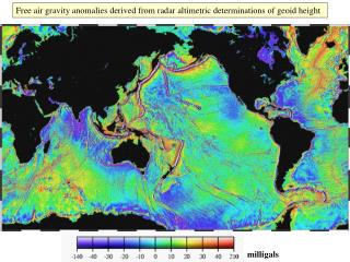
Long Wavelength - global Medium Wavelength - regional Short Wavelength - local High Resolution Geoid ModelsG99SSS (Scientific Model) • Earth Gravity Model of 1996 (EGM96) • 2.6 million terrestrial, ship-borne, and altimetric gravity measurements • 30 arc second Digital Elevation Data • 3 arc second DEM for the Northwest USA • Decimated from 1 arc second NGSDEM99 • Computed on 1 x 1 arc minute grid spacing • GRS-80 ellipsoid centered at ITRF97 origin
High Resolution Geoid ModelsUSGG2003 (Scientific Model) • 2.6 million terrestrial, ship, and altimetric gravity measurements • offshore altimetry from GSFC.001 instead of KMS98 • 30 arc second Digital Elevation Data • 3 arc second DEM for the Northwest USA • Decimated from 1 arc second NGSDEM99 • Earth Gravity Model of 1996 (EGM96) • Computed on 1 x 1 arc minute grid spacing • GRS-80 ellipsoid centered at ITRF00 origin
h N Geoid Height (GEOID03) Ellipsoid (NAD 83) Geoid (NAVD 88) Ellipsoid, Geoid, and Orthometric Heights H = Orthometric Height(NAVD 88) h = Ellipsoidal Height (NAD 83) H = h - N N = Geoid Height (GEOID 03) TOPOGRAPHIC SURFACE H A B
h h h h H h H H H N N N N N H Earth’s Surface Composite Geoids • Gravity Geoidsystematic misfit with benchmarks • Composite Geoidbiased to fit local benchmarks • e = h – H - N Ellipsoid Hybrid or Composite Geoid =~ NAVD 88 0.308 M in Montana – 2003 model 0.271 M in Traverse City – 1999 model Gravity Geoid
High Resolution Geoid ModelsGEOID03 (vs. Geoid99) • Begin with USGG2003 model • 14,185 NAD83 GPS heights on NAVD88 leveled benchmarks (vs. 6169) • Determine national bias and trend relative to GPS/BMs • Create grid to model local (state-wide) remaining differences • ITRF00/NAD83 transformation (vs. ITRF97) • Compute and remove conversion surface from USGG2003
High Resolution Geoid ModelsGEOID03 (vs. Geoid99) • Relative to non-geocentric GRS-80 ellipsoid • 2.7 cm RMS nationally when compared to BM data (vs. 4.6 cm) • RMS 50% improvement over GEOID99 (Geoid96 to 99 was 16%)
Sample Datasheet • National Geodetic Survey, Retrieval Date = DECEMBER 28, 2005 • PL0314 *********************************************************************** • PL0314 DESIGNATION - V 27 • PL0314 PID - PL0314 • PL0314 STATE/COUNTY- MI/GRAND TRAVERSE • PL0314 USGS QUAD - • PL0314 • PL0314 *CURRENT SURVEY CONTROL • PL0314 ___________________________________________________________________ • PL0314* NAD 83(1994)- 44 39 02.41202(N) 085 46 04.27942(W) ADJUSTED • PL0314* NAVD 88 - 257.838 (meters) 845.92 (feet) ADJUSTED • PL0314 ___________________________________________________________________ • PL0314 X - 335,419.145 (meters) COMP • PL0314 Y - -4,532,722.532 (meters) COMP • PL0314 Z - 4,459,971.520 (meters) COMP • PL0314 LAPLACE CORR- 5.18 (seconds) DEFLEC99 • PL0314 ELLIP HEIGHT- 223.17 (meters) (07/17/02) GPS OBS • PL0314 GEOID HEIGHT- -34.68 (meters) GEOID03 • PL0314 DYNAMIC HT - 257.812 (meters) 845.84 (feet) COMP • PL0314 MODELED GRAV- 980,508.8 (mgal) NAVD 88 • PL0314 H h N
Sample Datasheet • PL0314 • PL0314 HORZ ORDER - FIRST • PL0314 VERT ORDER - FIRST CLASS II • PL0314 ELLP ORDER - FOURTH CLASS I • PL0314 • PL0314.The horizontal coordinates were established by GPS observations • PL0314.and adjusted by the National Geodetic Survey in February 1997. • PL0314 • PL0314.The orthometric height was determined by differential leveling • PL0314.and adjusted by the National Geodetic Survey in June 1991. • PL0314 • PL0314.The X, Y, and Z were computed from the position and the ellipsoidal ht. • PL0314 • PL0314.The Laplace correction was computed from DEFLEC99 derived deflections. • PL0314 • PL0314.The ellipsoidal height was determined by GPS observations • PL0314.and is referenced to NAD 83. • PL0314 • PL0314.The geoid height was determined by GEOID03. • PL0314 • PL0314.The dynamic height is computed by dividing the NAVD 88 • PL0314.geopotential number by the normal gravity value computed on the • PL0314.Geodetic Reference System of 1980 (GRS 80) ellipsoid at 45 • PL0314.degrees latitude (g = 980.6199 gals.). • PL0314 • PL0314.The modeled gravity was interpolated from observed gravity values. • PL0314
Sample Datasheet • PL0314 • PL0314.The modeled gravity was interpolated from observed gravity values. • PL0314 • PL0314; North East Units Scale Factor Converg. • PL0314;SPC MI C - 149,194.606 5,888,865.237 MT 0.99992569 -0 59 23.3 • PL0314;SPC MI C - 489,483.62 19,320,424.01 FT 0.99992569 -0 59 23.3 • PL0314;UTM 16 - 4,944,883.803 597,700.224 MT 0.99971738 +0 51 57.6 • PL0314 • PL0314! - Elev Factor x Scale Factor = Combined Factor • PL0314!SPC MI C - 0.99996501 x 0.99992569 = 0.99989070 • PL0314!UTM 16 - 0.99996501 x 0.99971738 = 0.99968240 • PL0314 • PL0314 SUPERSEDED SURVEY CONTROL • PL0314 • PL0314 ELLIP H (02/03/97) 223.19 (m) GP( ) 4 1 • PL0314 NAD 83(1986)- 44 39 02.41257(N) 085 46 04.28315(W) AD( ) 1 • PL0314 NAD 83(1986)- 44 39 02.38347(N) 085 46 04.27988(W) AD( ) 3 • PL0314 NAVD 88 (09/30/91) 257.84 (m) 845.9 (f) LEVELING 3 • PL0314 NGVD 29 (??/??/92) 257.915 (m) 846.18 (f) ADJ UNCH 1 2 • PL0314 • PL0314 Superseded values are not recommended for survey control. • PL0314.NGS no longer adjusts projects to the NAD 27 or NGVD 29 datums. • PL0314
Sample Datasheet • PL0314_U.S. NATIONAL GRID SPATIAL ADDRESS: 16TEQ9770044884(NAD 83) • PL0314_MARKER: DB = BENCH MARK DISK • PL0314_SETTING: 7 = SET IN TOP OF CONCRETE MONUMENT • PL0314_SP_SET: CONCRETE POST • PL0314_STAMPING: V 27 1930 846.176 • PL0314_MARK LOGO: CGS • PL0314_MAGNETIC: N = NO MAGNETIC MATERIAL • PL0314_STABILITY: B = PROBABLY HOLD POSITION/ELEVATION WELL • PL0314_SATELLITE: THE SITE LOCATION WAS REPORTED AS SUITABLE FOR • PL0314+SATELLITE: SATELLITE OBSERVATIONS - October 24, 1992 • PL0314 • PL0314 HISTORY - Date Condition Report By • PL0314 HISTORY - 1930 MONUMENTED CGS • PL0314 HISTORY - 1951 GOOD NGS • PL0314 HISTORY - 1984 GOOD NGS • PL0314 HISTORY - 19890428 GOOD NGS • PL0314 HISTORY - 1990 GOOD USPSQD • PL0314 HISTORY - 19910701 GOOD NGS • PL0314 HISTORY - 19920824 GOOD MIDT • PL0314 HISTORY - 19921024 GOOD MIDT • PL0314 HISTORY - 19971029 GOOD USPSQD • PL0314 • PL0314 STATION DESCRIPTION • PL0314 • PL0314'DESCRIBED BY NATIONAL GEODETIC SURVEY 1951 • PL0314'IN INTERLOCHEN. • PL0314'AT INTERLOCHEN, 131 FEET EAST OF THE JUNCTION OF THE ABANDONED • PL0314'BRANCH OF THE MANISTEE AND NORTHEASTERN RAILROAD AND THE C AND
Sample Datasheet • National Geodetic Survey, Retrieval Date = DECEMBER 28, 2005 • PL0314 *********************************************************************** • PL0314 DESIGNATION - V 27 • PL0314 PID - PL0314 • PL0314 STATE/COUNTY- MI/GRAND TRAVERSE • PL0314 USGS QUAD - • PL0314 • PL0314 *CURRENT SURVEY CONTROL • PL0314 ___________________________________________________________________ • PL0314* NAD 83(1994)- 44 39 02.41202(N) 085 46 04.27942(W) ADJUSTED • PL0314* NAVD 88 - 257.838 (meters) 845.92 (feet) ADJUSTED • PL0314 ___________________________________________________________________ • PL0314 X - 335,419.145 (meters) COMP • PL0314 Y - -4,532,722.532 (meters) COMP • PL0314 Z - 4,459,971.520 (meters) COMP • PL0314 LAPLACE CORR- 5.18 (seconds) DEFLEC99 • PL0314 ELLIP HEIGHT- 223.17 (meters) (07/17/02) GPS OBS • PL0314 GEOID HEIGHT- -34.68 (meters) GEOID03 • PL0314 DYNAMIC HT - 257.812 (meters) 845.84 (feet) COMP • PL0314 MODELED GRAV- 980,508.8 (mgal) NAVD 88 • PL0314 H h N NAVD88 – Ellip Ht + Geoid Ht = … 257.838 – 223.17 – 34.953 = -0.285 USGG2003 257.838 – 223.17 – 34.68 = -0.012 GEOID03
Plans for Geoid Modeling at NGS • Near term plans are to define gravimetric geoids and hybrid geoids for all U.S. territories (USGG2006 & GEOID06). • Gravimetric geoids would all have a common Wo value (geoid datum) and be based on GRACE-based global gravity models such as the forthcoming EGM06 from NGA • Gravimetric geoids will be tested against tide gauges and lidar-observed sea surface heights to confirm choice of Wo. • Hybrid geoids would be tied to NAD 83 & local vertical datums • NAVD 88 for Alaska and CONUS • PRVD02 for Puerto Rico • Etc. • The quality of VDatum will be improved as the ties between the oceanic and terrestrial datums are better understood. • Likewise, it would be very useful in providing decimeter or better accurate heights to estimate flooding potential.
Plans for Geoid Modeling at NGS (cont.) • Long term goals are to define a cm-level accurate geoid height model valid for all of North America • Work is ongoing with the Canadians • Other nations joining in (Mexico/INEGI, etc.) • We likely will also adopt a vertical datum based on a refined geoid height model – the ultimate in Height Mod! • Conversion surface will provide means of transforming between this new datum and NAVD 88 – much as VERTCON does now between NGVD 29 and NAVD 88. • This maintains compatibility with archival data. • To do this, several major areas need work: • Gravity database cleansing/analysis/standardization • Acquisition of additional data sets • Refinement of geoid theory
Ongoing research areas • We must have a consistent and seamless gravity field at least along the shorelines if not across all the U.S. • Use GRACE data to test long wavelength accuracy. • Use aerogravity to locate and possibly clean systematic problems in terrestrial or shipborne surveys (biases, etc.). • Determine and remove any detected temporal trends in the nearly 60 years of gravity data held by NGS. Ensure consistency of datums, corrections and tide systems. • This solves problems of current remove-compute-restore approach, which honors terrestrial data over EGM’s. • Exploration of utility of coastal/littoral aerogravity • Need a consistent gravity field from onshore to offshore. • Aids in database cleansing; also fills in coastal gaps. • Ties to altimetric anomalies in deeper water. • In conjunction with tide gauges & dynamic ocean topography models, this will aid in determining the optimal geopotential surface for the U.S. (Wo).
Ongoing research areas (cont.) • Must acquire data and models for outlying regions. • Definitely need surface gravity (terrestrial and shipborne) and terrain models for Guam, CNMI, American Somoa. • Desire to get such for nearest neighbors including Mexico, Caribbean nations, Central American nations, etc. • Also need to get any available forward geophysical models for all regions (such as ICE-5G for modeling the Glacial Isostatic Adjustment). • GPS/INS evaluation of the gravity field. • GPS & IMU information were also collected on flights. • This data can be used to derive gravity disturbances and to estimate gravity anomalies. • It may be useful in benign areas for determining the gravity field. Possibly cheaper and more cost-effective than aerogravity (run with other missions?).
Ongoing research areas (cont.) • Geodetic theory improvements. • Downward continuation of high altitude gravity observations. • Merging of gravity field components. • Current approach is remove-compute-restore. • Spectral merging of EGM, gravity and terrain data. • Would honor long wavelength (GRACE). • Retain character of the terrain and observed data. • Determination of geoid height using ellipsoidal coordinates instead of the spherical approximation. • Resolution of inner and outer zone effects from terrain on gravity observations.
Gravity measurements help answer two big questions… How “high above sea level” am I? (FEMA, USACE, Surveying and Mapping) How large are near-shore hydrodynamic processes? (Coast Survey, CSC, CZM) Earth’s Surface Orthometric Ht From Leveling Geoid Coast Ocean Surface Ellipsoid Geoid Height From Gravity Ellipsoid Ht From GPS From Satellite Altimetry
Geoid = global MSL Average height of ocean globally Where it would be without any disturbing forces (wind, currents, etc.). Local MSL is where the average ocean surface is with the all the disturbing forces (i.e., what is seen at tide gauges). Dynamic ocean topography (DOT) is the difference between MSL and LMSL: LMSL = MSL + DOT Hence: error = TG – DOT - N N Tide gauge height ellipsoid LMSL DOT geoid Relationships NAVD 88
J24 J22 J21 J20 J18 J14 J12 J11 M30 M28 M24 M22 M21 M20 M18 M14 M12 M11 J25 J19 J17 J15 M29 M27 M25 M19 M17 M15 J26 J23 J16 J13 M26 M23 M16 M13 J10 J8 J4 J2 J1 M10 M8 M4 M2 M1 J9 J7 J5 M9 M7 M5 J6 J3 M6 M3 T1 T2 T3 T4 T5 T6 T7 T8
tidal benchmarks with a NAVD88 tie tidal benchmarks without a NAVD88 tie
Expected Results • A Consistent vertical datum between all U.S. states and territories as well as our neighbors in the region. • Reduce confusion between neighboring jurisdictions. • Local accuracy but national consistency. • This provides a consistent datum for disaster management. • Storm surge, tsunamis, & coastal storms. • Disasters aren’t bound by political borders. • Heights that can be directly related to oceanic and hydrologic models (coastal and inland flooding problems). • The resulting improvements to flood maps will better enable decision making for who does & doesn’t need flood insurance. • Updates to the model can be made more easily, if needed, to reflect any temporal changes in the geoid/gravity. • Finally, offshore models of ocean topography will be improved and validated. These models will provide better determination of offshore water flow (useful for evaluating the movement of an oil slick).
QUESTIONS? Geoid Research Team: Dr. Daniel R. Roman, research geodesist dan.roman@noaa.gov Dr. Yan Ming Wang, research geodesist yan.wang@noaa.gov Jarir Saleh, ERT contractor, gravity database analysis William Waickman, programming & database access Website: http://www.ngs.noaa.gov/GEOID/ Phone: 301-713-3202