Download
1 / 6
60 likes | 210 Vues
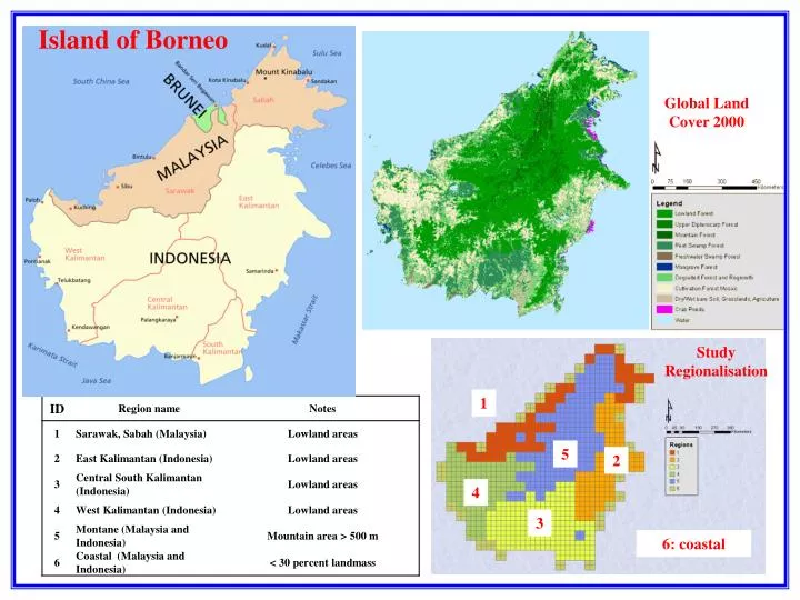
Island of Borneo. Global Land Cover 2000. Study Regionalisation. 1. 5. 2. 4. 3. 6: coastal. El Niño years: 1997, 1998, 2002, 2004, 2006. Sarawak & Sabah. East Kalimantan. Central-South Kalimantan. West Kalimantan. Montane. Coastal. ‘Whole of Island’ Relationship between

E N D
Island of Borneo Global Land Cover 2000 Study Regionalisation 1 5 2 4 3 6: coastal
El Niño years: 1997, 1998, 2002, 2004, 2006 Sarawak & Sabah East Kalimantan Central-South Kalimantan West Kalimantan Montane Coastal
‘Whole of Island’ Relationship between Area Burnt and Prior Rainfall • PAB month i = constant × e B1 × rainfall_lag k, • where k = 0 (present month’s rainfall), k=1 (average of current and previous month’s rainfall),…, and k=11 (average of last 12months rainfall, including current month’s rainfall). • Highly negative B1 values indicate a strong negative correlation between fire and rainfall.
Spatial Distribution of Relationship between Area Burnt and Prior Rainfall Strong negative correlation between fire and rainfall Weak correlation between fire and rainfall
% cover Landcover 2007 Landcover 1997 Mean Annual PAB
Increasing PAB Increasing –ve slope in PAB wrt RF Increasing –ve slope in PAB wrt RF Increasing –ve slope in PAB wrt RF