Download
1 / 23
300 likes | 629 Vues
Sea Level Changes. Sea-Level Change. Sea-levels are predicted to rise by 1m this century (by 2100). Why?. Sea-Level Change Key Terms. Eustatic – global-scale sea level change caused by a change in the volume of water in the ocean store

E N D
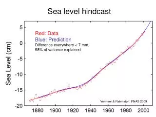
Sea-levels are predicted to rise by 1m this century (by 2100). Why?
Sea-Level Change Key Terms • Eustatic – global-scale sea level change caused by a change in the volume of water in the ocean store • Isostatic – local-scale sea level change caused by a change in the level of the land relative to the level of the sea. • Emergence – the impact of a relative FALL in sea level (Marine Regression) • Submergence – the impact of a RISE in relative sea level (Marine Transgression)
Eustatic change • A global sea level change, caused by climatic change which causes then size of ice caps to increase or decrease • During a period of glaciation sea level is much lower because water is stored as ice (during last ice age sea level was 150m below levels today)
Sea level changes in S. England Synoptic links with glaciation topic Flandrian Interglacial (last 10,000 yrs) The Devensian glacial advance
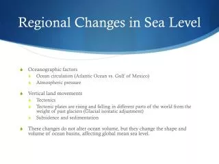
Isostatic change The change in the level of the land compared with the sea • During glaciation the ice puts pressure on the earth’s crust, causing the land to lower • When ice sheets melt the land rises (“readjustment”)
How fast is isostatic change? Land rising in NW Scotland by 1mm/yr Land sinking in SE England by 1.5 mm/yr
Sequence of sea level change Temperatures decrease. Ice sheets grow. Sea level falls Ice thickness increases. Land is lowered Temperatures rise. Ice melts. Sea levels rise Ice continues to melt. Pressure on land released. Land rises
But how do we know all this? • Accurate measurements can be made of past sea levels and rates of sea advance and retreat by …. • Shoreline deposits such as shells, wood and peat found in marine cores. • Exposed rock outcrops containing marine fossils. • Vegetated tidal flats above the high water mark. • Exposed coral reefs. • Marine rocks displaying evidence of wind-borne erosion. • Radiocarbon and Uranium series dating
Landforms of Submergence • Rias • Fjords • Fjards – submerged glacial lowlands • Dalmatian Coasts – submerged valleys running parallel to the coast
Rias Rias are submerged river valleys. The lowest part of the river’s course and the floodplains alongside the river may be completely drowned, but the higher land remains exposed, e.g. Kingsbridge Estuary, Devon
In cross section the ria has relatively shallow water becoming increasingly deep towards the centre. The exposed valley sides are quite gently sloping. • In long section rias are quite even with a smooth profile and water of uniform depth. • In plan view they tend to be winding, reflecting the original route of the river and its valley.
Fjords Fjords are submerged glacial valleys. They have steep, cliff-like valley sides and the water is uniformly deep (often 1000m in depth). These were formed when glaciers eroded below sea-level. When the ice melted the valleys were flooded, e.g. Milford Sound fjord, New Zealand
The u-shaped cross-section reflects the original shape of the glacial valley. • Unlike rias, fjords are not deepest at their mouths, but have a shallow section at the seaward end known as the threshold. • Fjords have much straighter routes, due to the erosive power of the glacier.
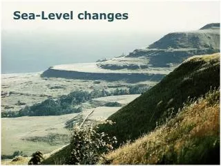
Landforms of Emergence • Raised Beaches • Abandoned Coastlines
Raised Beaches Raised beaches, e.g. Little Gruinard, Ullapool are areas of former wave-cut platforms and their beaches which are left at a higher level than the present coastline. Abandoned cliffs, caves and stacks can also be found.
Landforms resulting from net sea level rise – submerged coasts Rias • Drowned river valleys caused by rising sea levels during Flandarin Transgression (ice melt) • Eg Rivers Fal & Camel in Cornwall Fjords • Drowned U shaped glacial valleys • Eg Loch Torridan in Scotland, Oslo Fjord Fjards • Drowned glacial lowlands
Landforms resulting from net fall in sea level – emerged coastlines Raised beach • e.g Portland raised beach Relict cliffs • Previous coastal cliffs that are raised above current sea level Raised mudflats • e.g Carselands of River Forth
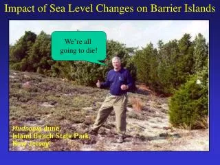
What will the effects of sea level rise be in the future? More than 60% of the world’s population lives on or within 60km of the coast. Synoptic link to AS climate change – find your notes!! You need to know causes, effects and responses.
Effects in the UK Environmental: • The threat of nuclear accidents will be higher at Sizewell and Dungeness as they are built on low lying land. Dungeness is built on a shingle spit which is moving eastwards. • 62 coastal SSSIs will be at risk from sea level rise. • Habitats will be lost - 10% of saline lagoons and 8% of salt marsh is at risk. • Coastal squeeze may result in more coastal ecosystems lost as they cannot migrate inland as the sea level rises. • Migratory birds such as the Grey Plover and Avocet over-wintering in The Wash, Thames and Humber estuaries will lose their habitat. • Of the 106 internationally important sites for wintering wildfowl, 16 are at risk and 11 are vulnerable.
Social 26 million people live in major urban areas in the coastal zones. People continue to build on low lying coastline despite the threat of increased flooding. Economic 40% of manufacturing and 57% of productive agricultural land is in the coastal zone. Coastal zone along the South coast is valued at £5745 million. Cost of protecting these areas will be high. Cost of insurance claims and repairs if storms to breach sea walls. Towyn in 1990 cost £35 million. Loss of tourist areas would result in a loss of income. Norfolk Broads are estimated to earn £15.5 million per year. Homes will be uninsurable.
Effects on the Maldives • The islands of Tebua Tarawa and Abanuea (both uninhabited) have disappeared underwater. • Most of the 29 atolls are suffering from increased erosion. • Severe flooding both storms and high tides have occurred. • Salt is poisoning the soil. • Beaches of a third of the 200 Maldives islands are being washed away affecting both erosion rates and tourism.