Download
1 / 1
10 likes | 116 Vues
Environmental Impact of Quarrying in the Province of Sidi Bennour (Doukkala, Morocco). Geological Society of America 2012 Annual Meeting - November 4-7 , 2012, Charlotte, North Carolina .

E N D
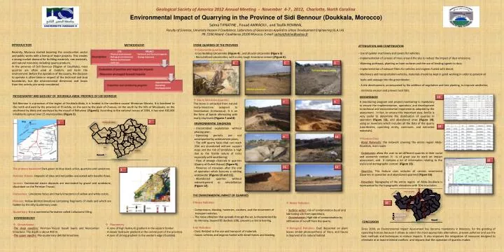
Environmental Impact of Quarrying in the Province of Sidi Bennour (Doukkala, Morocco) Geological Society of America 2012 Annual Meeting - November 4-7 , 2012, Charlotte, North Carolina Salma TIFRATINE , Fouad AMRAOUI , and Toufik REMMAL Faculty of Sciences, University Hassan II Casablanca, Laboratory of Geosciences Applied to Urban Development Engineering (G.A.I.A) PB .5366 Maarif- Casablanca 20100 Morocco. E-mail: salmatifratine@yahoo.fr INTRODUCTION Recently, Morocco started boosting the construction sector and public works with a lineup of major projects. This creates a strong market demand for building materials, raw materials, and natural resources including quarry products. In the province of Sidi Bennour (Region of Doukkala), most quarries are often used at random, and harm the environment. Before the operation of the quarry, the decision to operate is often taken in respect of the technical and land boundaries, but the environmental dimension and losses from this activity are rarely considered. METHODOLOGY STONE QUARRIES OF THE PROVINCE ATTENUATION AND COMPENSATION - Use of quieter machinery and covers for vehicles; - Implementation of screens of trees around the site to reduce the impact of dust emissions; - Watering pathways, planting on bare surfaces and the use of binding agents to dust; - Implementation of exhaust filters for vehicles and engines fueled with diesel; - Machinery and transportation vehicles, materials should be kept in good working in order to prevent oil leaks and seepage into the groundwater; - A site development, accompanied by the addition of vegetation and tree planting, to improve aesthetics, minimize erosion and prevent rock falls; • Calcarenite quarries : • Cross Bedding calcarenites (Figure 4) , and alluvial calcarenite (Figure 5) • - Recrystallized calcarenites, with a very tough limestone cement;(Figure 6). • PROJECT • Technical and financial aspects • Energy resources • SITE • Physical environment • Biological environment • Human Environment • Land use Silty Coverage 4 5 6 Calcarenite Recrystallized calcarenite • Implementation • Operating • Developpement Alluvial calcarenite PHYSIOGRAPHY AND GEOLOGY OF DOUKKALA-ABDA: PROVINCE OF SIDI BENNOUR Sidi Bennour is a province of the region of Doukkala-Abda, it is located in the southern coastal Moroccan Meseta. It is bordered to the north and west by the province of El Jadida, on the east by the plain of Chaouia, on the south by the hills of Mouissate, on the southwest by Abda and southeast by the massif of Rehamna (Figure1). According to the national census of 2004, it has over 400,000 inhabitants spread over 25 municipalities (Figure 2). GEODATABASE 13 • Marly limestone quarries : • The stone is extracted from natural marly-limestone assigned to Cenomanian (Cretaceous). It is on the form of bands alternating with marly-clay levels (Figures 7 and 8). 7 8 • A monitoring program and project monitoring is mandatory to ensure the implementation, operation, and development to technical and environmental requirements adopted by the assessment. In fact, to ensure this important step, ArcGis is very useful to determine the distribution of quarries in operation (Figure 13), and abandoned ones (Figure 14), using an inventory which includes all the Data of the quarry (coordinates, operating entity, commune, and extracted materials). 2 1 ENVIRONMENTAL DIAGNOSIS 14 • Uncontrolled exploitation without phasing plan; • Operating permits are not accompanied by achievement plans; • The stiff quarry faces that can reach 20m are abandoned without support steps and the risk of landslides is high due to the friable nature of rocks especially with weathering; • Flow of sewage channels in quarries (Quarry of Ouled Chaoui) (Figure 9); • Presence of crevasses after the end of operation which become a settling wastewater (Figures 10 and 11); • Abandoned quarries without redevelopment or rehabilitation (Figure 12); 9 10 • Feature Class • Road Networks: the network covering the entire region Abda-Doukkala, main roads • Communes: allow the user to set different quarries in their social and economic context. It is of great use to work on impact assessment, and it contains a lot of information relating to the social and demographic context (Figure 15) . • Quarries:This feature class includes all careers inventoried (Quarries in operation and abandoned quarries) (Figure 16). • Elevation:Topography of the entire region of Abda-Doukkala is represented by the topographic elevations with 30m resolution. 15 • The primary basement Dark green to blue-black schist, quartzite and sandstone • Permian Triassic:Deposits of clays and red pelites associated with basaltic flows. • Jurassic:Continental clastic deposits are dominated by gravel and sandstone, discordant on the Permian-Triassic. • Cretaceous: Limestone facies and marly limestones of yellow and white colors. • Pliocene: Yellow detrital limestone containing fragments of shells and which are hidden by the silty Quaternary cover. • Quaternary: It is a continental formation called Colluviums filling. 11 12 3 • THE ENVIRONMENTAL IMPACT OF QUARRIES • Noise Pollution • - Compressors, blasting, hammers, crushers, and the movement of • transport vehicles. • - The noise vibration that spreads through the air, is characterized by • its intensity, beyond 85 decibels (dB), presents a risk to hearing. • Air Pollution • - Dust: Related to the use and transport of materials. • - Gases: vehicles and engines fueled with diesel fumes and blasting. • Water Pollution • - Surface water:risk of contamination by oil and lubricating oils from operations. • - Groundwater: High risk of contamination by infiltration of runoff from the quarry. • Biological Pollution: Dust deposited on plant leaves inhibit photosynthesis of Flora, and Fauna is deprived of its natural habitat. 16 HYDROGEOLOGY CONCLUSION Since 2009, an Environmental Impact Assessment has become mandatory in Morocco, for the granting of operating licenses because it allows to select the most appropriate alternatives, prevent pollution and use the best methods and techniques to reduce impacts. It also improves the integration of measures designed to eliminate or at least minimize conflicts and impacts that the operation of quarries makes . • Groundwater • The deep aquifers:Permian-Triassic basalt layers and Neocomian limestone. The depth is about 400 m. • -The upper aquifer:Plio-quaternary detrital limestone. • Piezometry • - A zone of high hydraulic gradient in the eastern border. • - A slower hydraulic gradient in the central part of the province. • - A zone of strong gradient in the western edge (Oualidia).