Download
1 / 7
70 likes | 145 Vues
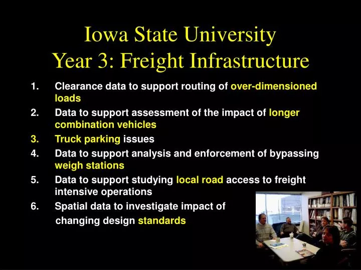
Iowa State University Year 3: Freight Infrastructure. Clearance data to support routing of over-dimensioned loads Data to support assessment of the impact of longer combination vehicles Truck parking issues Data to support analysis and enforcement of bypassing weigh stations

E N D
Iowa State UniversityYear 3: Freight Infrastructure • Clearance data to support routing of over-dimensioned loads • Data to support assessment of the impact of longer combination vehicles • Truck parking issues • Data to support analysis and enforcement of bypassing weigh stations • Data to support studying local road access to freight intensive operations • Spatial data to investigate impact of changing design standards
1. Over Dimensioned Shipments • Many states use manual methods • Automated routing software is available (and in use in some states) • Data requirements are a barrier • Can remote sensing provide some of the data? • Spatial resolution requirements • Temporal resolution requirements • Data types • Satellite imagery (photo interpretation or automated extraction) • Video processing (video log van, heads up measurement) • GIS (routes with functional class, ownership, capacity, bridge limits, etc.)
2. Longer Combination Vehicles • Longer combination vehicles (LCVs) are allowed in some western states, and proposed in others • There are safety and maneuverability issues • Infrastructure is limited, particularly in urban areas • No systematic data exist for LCV capacity • Propose to develop procedure for overlay of LCV turning templates on aerial photography to assess limitations • Useful in policy assessment and designation of truck routes • Data types • Satellite and aerial imagery • GIS (truck routes, business type and location)
3. Truck Parking Issues • Truck parking capacity • Rest areas • Private parking lots • Truck maneuverability issues • Private lots • Air quality impacts • Proximity to sensitive land use • Access management • Driveways to accommodate trucks may have negative impact on auto access • Reconfigured driveways may provide reduced truck impact • Data types • Satellite and aerial imagery • GIS (land use and business location/type)
4. Weigh Station Enforcement • Permanent weigh stations may be bypassed • Bypass routes may suffer damage, may be safety problem • Difficult to identify extent of problem • Identify likely bypass routes • Monitor truck behavior • Data types • Video vehicle matching (2 autoscope • trailers) • GIS truck AADT, pavement info
5. Local Freight Roads • The “last mile” • Heavy load freight generators dispersed • Grain elevators • Where are the generators? • What are the characteristics of these access roads? • How do trucks and farm vehicles use access roads? • Data types • Satellite or aerial imagery to identify generators • GIS (generators or markets)
6. Changing Standards • Low volume roads (AASHTO), Rail curvature standards (AREMA), Highway sight distance standards (AASHTO) • Shipment size affects frequency, communications and control • Additional service may require system “adjustments” • More feasible than providing infrastructure for larger shipments • Smaller, more frequent rail shipments provide unique challenges (Netherlands, Germany) • “Adjustments” may include siding, yards • Use sensing to determine feasible locations for system modifications • Impact of changing passing sight distance in combination with increasing truck volumes • Where are the passing zones now? • Data types • GIS (alignments, density) • Satellite or aerial imagery for ROW constraints


![The ONCE and FUTURE [e-] JOURNAL](https://cdn0.slideserve.com/1357417/the-once-and-future-e-journal-dt.jpg)