Download
1 / 25
250 likes | 424 Vues
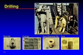
DEEP GROUNDWATER DRILLING. CENTRAL TEXAS BY WILLIAM FEATHERGAIL WILSON, PG #21 STRATA GEOLOGICAL SERVICES GSA - 2008. TEXAS HILL COUNTRY. Regional Cross-Section. KERR COUNTY. RESEARCH WELLS (12). 8. 4. 9. 6. 5. 7. 11. 3. 2. 1. RESEARCH WELLS (12).

E N D
DEEP GROUNDWATER DRILLING CENTRAL TEXAS BY WILLIAM FEATHERGAIL WILSON, PG #21 STRATA GEOLOGICAL SERVICES GSA - 2008
RESEARCH WELLS (12) 8 4 9 6 5 7 11 3 2 1
RESEARCH WELLS (12) • Drilled through the entire Cretaceous System • Depths ranges: 610’-1330’ (~ 11,000’) • Lithologic logs – stereo microscope @ 10’ intervals • Geophysical logs • Drilled 12 wells – 8 years – HGCD Conservation district
RESEARCH WELL RESULTS • MAPS • ISOPACH • FACIES • ISOTOPE AGES • FLOW DIRECTIONS • RECHARGE CONCEPTS • CROSS-SECTIONS • ANALYTICAL MODELING • AQUIFER AGE DATES – ISOTOPES • PUMP TESTS • DEMAND –SUPPLY PREDICTIONS
Cretaceous Stratigraphy Fm/Group Members Trinity Period Age 99 Edwards Albian Upper Lower Upper Glen Rose 112 Hensel Bexar Cow Creek Hammett Cretaceous Middle Pearsall Aptian 121 Sligo Neocomian Lower Hosston 144
C-14 Aquifer Age Dates (uncorrected) 1000-40,000 years <10,000 >20,000
% Modern Carbon High Low
GROUNDWATER STORAGE The Hammett clay wedge separates the Hensel South from the Hensel North via facies change 11,986 ac ft recoverable sans annual recharge 15,981 ac ft using 20% recovery Mean aquifer thickness
SUMMARY • REPRESENTS A SNAPSHOT OF DEEP GROUNDWATER DRILLING IN CENTRAL TEXAS • ADDITIONAL PRIVATE AND PUBLIC DEEP DRILLING HAS BEEN CARRIED OUT ACROSS THE TEXAS HILL COUNTRY UTILIZING THE SAME TECHNIQUES • RESEARCH CONTINUES IN COOPERATION WITH WATER DISTRICTS, DEVELOPERS, AND PUBLIC WATER SYSTEMS
SUMMARY • KERR COUNTY DETAILED REPORT (BOOK) BEING PREPARED (~120 PAGES), MAPS, CROSS-SECTIONS, ETC. • RESEARCH WILL BE EXPANDED TO INCORPORATE DEEP GROUNDWATER DRILLING DATA AND INTERPRETATION ACROSS ADJACENT COUNTIES
CONTACT INFORMATION • WILLIAM FEATHERGAIL WILSON, PG #21 • Strata Geological Services • 13505 FM 462 • Bandera (Tarpley), Texas 78003 • E-mail <featherg@hctc.net> • Office – 830-562-3680 • Thank You!