Download
1 / 7
70 likes | 247 Vues
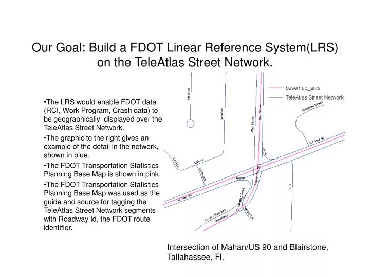
Our Goal: Build a FDOT Linear Reference System(LRS) on the TeleAtlas Street Network. The LRS would enable FDOT data (RCI, Work Program, Crash data) to be geographically displayed over the TeleAtlas Street Network.

E N D
Our Goal: Build a FDOT Linear Reference System(LRS) on the TeleAtlas Street Network. The LRS would enable FDOT data (RCI, Work Program, Crash data) to be geographically displayed over the TeleAtlas Street Network. The graphic to the right gives an example of the detail in the network, shown in blue. The FDOT Transportation Statistics Planning Base Map is shown in pink. The FDOT Transportation Statistics Planning Base Map was used as the guide and source for tagging the TeleAtlas Street Network segments with Roadway Id, the FDOT route identifier. Intersection of Mahan/US 90 and Blairstone, Tallahassee, Fl.
Step 1: FDOT Roadway Ids were transferred from the System Planning Base Map to TeleAtlas Street segments. If a FDOT Route is represented in the TeleAtlas Street Network as a double alignment, both sides received the FDOT Roadway Id.
Components of the LRS. • Each Segment is tagged with the Roadside, BMP (Begin Mile Post), and EMP (Ending Mile Post). • The mile post fields are based on linear length of the segment.
Calibration of the LRS. • Calibration nodes were snapped into the street network to force the mile post values to agree with mile posts shown in the straight line diagrams and intersection tables in RCI . • The final. adjusted BMP/EMP values are stored in the fields BMPADJ and EMPADJ.
FDOT Roadway Ids for Off System Roads. • Federal Highways has charged the Safety Office the task of identifying high crash risk segments on off system roads. • To be able to do this analysis, off system street segments had to be grouped in logical corridors/routes. Each corridor/route was given a pseudo FDOT Roadway Id. • The FDOT pseudo Roadway Id consisted of the two digit FDOT county number, “A”, and a unique number, 5 digits long, left filled with zeros. • Every off system segment in the state was tagged with a pseudo FDOT Roadway Id. • Roadside, mile post info were added. • The off system routes were incorporated into the All Roads LRS..
Benefits of the All Roads LRS • Individual segments can be tagged with data from RCI or work program. • If these segments were input for a model, they would have values for AADT, number of lanes, area type, functional class, and work program • RCI , Work Program data exists within the State Highway System. AADT at the corner of Mahan(US 90) and Blairstone in Tallahassee is shown above.
Generating Data for Non SHS Segments • TeleAtlas is no longer the official street network for the State of Florida. • All information will be moved to the NavTeq Street Network • The same LRS is being created using the NavTeq Street Network. • The NavTeq Street Network will be available to all state agencies, local governments, MPOs. • Any agency that adopts the NavTeq Street Network as its base map can directly share any data like local counts, number of lanes, etc. • Routines have been developed to create links between the LRS and any other network. • These are the same routines that were used to move the LRS from TeleAtlas to NavTeq. • In the near future there will be pilot projects to create links between a local GIS base map and the All Roads base map (the NavTeq version) • Data from the local agency could then flow to its counterpart in the All Roads LRS and vice versa. • These additional data sources would benefit both local and statewide models.