Download
1 / 29
290 likes | 444 Vues
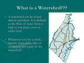
Paradise Stream Watershed Assessment – Preliminary Data Gap Evaluation. Principle Investigator/ Presented by: Mr. Brian Oram, PG, PASEO Co-PI’s: Dr. Dale Bruns & Mr. Bill Toothill Wilkes University, GeoEnvironmental Sciences and Engineering http://www.wilkes.edu 1-800-572-4444 ext 4619.

E N D
Paradise Stream Watershed Assessment – Preliminary Data Gap Evaluation Principle Investigator/ Presented by: Mr. Brian Oram, PG, PASEO Co-PI’s: Dr. Dale Bruns & Mr. Bill Toothill Wilkes University, GeoEnvironmental Sciences and Engineering http://www.wilkes.edu1-800-572-4444 ext 4619
Center for Environmental Quality Non-profit/ equal opportunity employer, is operated and managed, within the GeoEnvironmental Sciences and Engineering Department. Outreach Programs • Environmental and Professional Education and Training • Applied Research and Water Quality Monitoring • Community and Business Outreach Programs • Private Well Owner/ Watershed Group Programs • Certified Testing Laboratory Website: http://www.water-research.net
Data Gap Analysis • Compile Available Data (Multiple Sources) • Correct Typographical Errors • Remove (<, >, 0, nd, ?) • Correct Date Errors – like 02/12/1192 • Develop Spatial Information for Sampling Sites • Evaluate other Sources of Spatial Data for [Dams, USGS Stations, Hazardous Sites, Roads, Land-Use Non-Point Sources (Septic, Stormwater Run-off) Hydrography.] • Present Readily Available Data using a Geographic Information System (GIS) and Lay Foundation for the Development of a Geospatial and Relational Database.
What is GIS? A GIS is defined as an organized collection of computer hardware, software, geographic data, and personnel designed to efficiently capture, store, update, manipulate, analyze, and display all forms of geographically referenced information. (ESRI, 1995). GIS is a very powerful tool for storing and accessing geographic information, conducting geographic analysis, and producing high-quality maps and other types of graphic output.
Sources of Data (Water Quality) • Brodhead Watershed Association (BWA) • Pennsylvania Department of Environmental Protection (PADEP) • Monroe County Planning Commission (MC) • Paradise Township (PADTWP) • Normandeau Associates/ Aventis (RMC) • Mount Pocono Municipal Authority (ITC) • USGS- Paradise/Swiftwater Creek (1966- 1980) • ALLARM-Paradise Creek
Data Sources (Spatial-GIS Data) • Monroe County Planning Commission • Wilkes University Center for Environmental Quality and GIS/Remote Sensing Laboratories • EPA Basins(http://www.epa.gov/OST/BASINS/)* • USGS • PAGIS Consortium (http://www.pagis.org) • Pennsylvania Spatial Data Access (PASDA) * Data requires correction
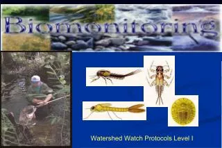
Importance of Volunteer Monitoring BWA- Brodhead Watershed Association
Overall Stream Quality Aquatic Life Cold Water Fishes—Maintenance or propagation, or both, of fish species including the family Salmonidae and additional flora and fauna which are indigenous to a cold water habitat. EV –CWF- Exceptional Value Cold Water Fishes Devils Hole – Basin to South Boundary of State Game Land HQ –CWF- High Quality Cold Water Fishes Devils Hole – From South Boundary of Games Land to MouthButz RunCranberry CreekSwiftwater CreekParadise Creek Unnamed Tributaries to Paradise Yankee Run Source:PACode93
Water Quality Data Needs • Establish Fixed Water Quality Stations and Establish Protocols for Testing, Monitoring, Sampling, and QC/QA Plan • Confirm Methods Used for Existing Data and Complete Screening of Existing Data • Develop a Field and Laboratory Data/ Reporting Format • Increase Monitoring Frequency (Monthly) at Selected Sites • Improve Field Monitoring Capability for Volunteer Groups • Stormwater or Storm Event Sampling • Real-Time/24-hour monitoring (?)
Hydrogeological Needs • Inventory of Water Sources (Wells and Springs) – PAGIS Data Inventory- Integration of Existing Wellhead Protection Program • Establish Stream Gauging Stations within the Watershed (Combination of Continuous and Fixed Point Stations) • Stream and Stream Bank Stability Assessment and Inventory
GIS Needs • Updated Land-Use/Land Cover Mapping and Base Maps for Project Area, and Intergrate Information from Pocono Watershed Assessment • Document Location and Description of Hazardous Sites (RCRA, LUST, UST, CERCLIS, TRI, RCRIS, NPDES, Large Volume Septic System, Spray Irrigation Systems etc) – Basins Database Outdated with Many Errors • Field Confirm Sampling Site Locations • Additional Corrections Needed to Available Public Datasets • Develop a Metadata Format and Acquire Metadata for Available Datasets
Paradise Stream Watershed Assessment – Preliminary Data Gap Evaluation Prepared by: Mr. Brian Oram, PG, PASEO Wilkes University, GeoEnvironmental Sciences and Engineering http://www.wilkes.edu1-800-572-4444 ext 4619