Download
1 / 26
260 likes | 264 Vues
This joint project between the U.S. Geological Survey and Florida Department of Environmental Protection aims to identify significant nutrient and pesticide inputs to the Chipola River/Floridan aquifer system. The study will characterize hydrologic and geochemical processes and test hypothetical scenarios to understand the impacts on water quality.

E N D
Nutrient and Pesticide Accounting in the Chipola River/Floridan Aquifer System A New Study Jointly Funded by U.S. Geological Survey and Florida Department of Environmental Protection By Christy Crandall
New Joint Project between FDEP and U.S. Geological Survey • Scheduled to start in January but all of the papers are still being signed • Hope to start next month
STUDY OBJECTIVES • Identify significant nutrients and pesticides inputs to the Chipola River/Floridan aquifer system using existing information • Characterize the hydrologic and geochemical processes occurring along flowpaths using a groundwater flow and tracking model and a geochemical model along flow paths. • Test 1 or possibly 2 hypothetical scenarios—tracking nitrate and maybe an organic compound to the Jackson Blue Spring and the Chipola River.
Study Area Location Chipola Watershed
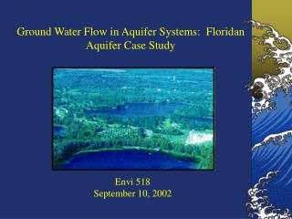
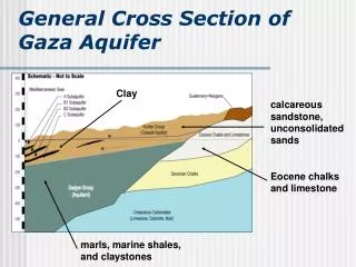
Vertically contiguous thick sequence of limestone and dolostone of late Paleocene to early Miocene age Highly potable--drinking water is derived from Floridan aquifer system Contains numerous springs, sinks and other karst features—highly vulnerable. Floridan Aquifer System
The Floridan aquifer and the Chipola River Basin • Recharge occurs mainly in unconfined and semi-confined areas • Potentiometric surface—flows southward from northern extent
The Floridan aquifer and the Chipola River Basin • Ground water makes up the majority of the Chipola River's discharge during low and medium flow conditions • At least 63 springs identified(Barrios and Chellette, 2004)
Why are we worried? • Higher nitrate concentrations and more occurrances of nitrate and pesticides in the Chipola River and Floridan aquifer in this area than in other areas of the Floridan aquifer system (U.S. Geological Survey data).
Groundwater Nitrate Concentrations were highest in ACFB Network Median NO3 ACFB 2.46 SANT 0.05 GAFL2 0.54 GAFL3 0.05 GAFL4 0.06
Number of Dectections ACF Basin pesticide detections in wells & springs Number of Dectections
Summary of SW Nutrients and Pesticides from 1995, USGS • Cowarts Creek nr. Cottonwood AL Median nitrate concentration 0.5 mg/L as N Nitrogen, Ammonia + Organic, Dissolved 0.25 mg/L as N Phosphorus, Total 0.03 mg/L as P Metolachlor 0.03 ug/L Atrazine 0.02 ug/L • Chipola River near Altha, FL Median nitrate concentration 0.5 mg/L Nitrogen, Ammonia + Organic, Dissolved 0.25 mg/L as N Phosphorus, Total 0.03 mg/L as P Metolachlor 0.05 ug/L
1.Acquire and compile existing data Water Quality Data FDEP USGS NWFWMD
Maps Land use Aquifer Vulnerability Potentiometric Surface Stream Aquifer Thickness
90000 80000 70000 60000 Houston County (Ala) 50000 Calhoun County 40000 Jackson County 30000 City of Marianna 20000 10000 0 1970 1980 1990 2000 Population Data Population in 2005
2. Use data to target top 30 source areas for nutrients and perform reconnaissance field sampling.Field ParametersNitrateBacteriaFew Pesticides?
3. Use new data to target 10 most significant source areas of nutrients and sample--analyses to include major ions, trace elements?, age tracers, isotopes, pesticides, etc.,.
4. During this time a ground-water flow and particle-tracking model will be compiled and calibrated for the Floridan/Chipola aquifer/river system
Start with existing Recent Models Lyn Torak USGS, Atlanta Hal Davis USGS, Tallahassee
5. Track particles along flow lines and identify geochemical processes occurring along flowpaths.
6. Use the model to test hypothetical scenarios such as: • the effects of changing BMPs • or zoning changes on predicted concetrations to the Chipola River and Blue Springs (3 to 5 locations).
Summary and Conclusions • New USGS MODFLOW CONDUIT FLOW PACKAGE can switch between laminar and turbulent flow • Project ends in 2009—I am hopeful that I may: • be able to provide some insight on travel time from aquifer recharge to river • identify some major source areas and vulnerable areas • and potentially say something about land use protection.