Download
1 / 16
160 likes | 419 Vues
Assessing Seismic (Cascadia Subduction Zone) Risk at Oregon Dams. Keith Mills, P.E., G.E. Dam Safety Engineer Oregon Water Resources Department. Oregon Statutory Dams. 10 feet or higher Over 9.2 acre feet of water Design review/approval Inspection frequency by hazard classification

E N D
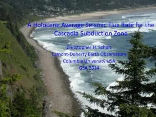
Assessing Seismic (Cascadia Subduction Zone) Risk at Oregon Dams Keith Mills, P.E., G.E. Dam Safety Engineer Oregon Water Resources Department
Oregon Statutory Dams • 10 feet or higher • Over 9.2 acre feet of water • Design review/approval • Inspection frequency by hazard classification • High – annual inspection • Plus Emergency Action Plans (EAPs) • Significant – Once every 2-3 years • Low – Once every 5-6 years • Federal Agencies responsible for their dams • Dam information in database on the web High Hazard 61/130 Significant Hazard 152/175 Low Hazard 733/939 1244
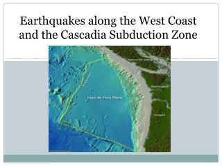
OWRD Seismic Hazards Assessment36 high hazard dams closest to Cascadia S.Z. • Dams west of longitude 123.0 degrees • 3 State regulated dams - current and satisfactory seismic analysis • 1 State regulated dam with analysis showing failure at 0.15 g • 3 State regulated dams with indicators of liquefaction potential • 1 USBR dam - unsatisfactory seismic analysis (deformation) • Remaining dams unknown (to OWRD) but with no major apparent indicators of liquefiable or highly compressible foundations or with hydraulically placed embankment materials.
Priorities for Seismic AnalysisNeed for seismic stability modifications • Big Creek Upper and Lower dams (Newport) • In progress (HDR/Cornforth) • Bear Creek dam (Astoria) • Re-investigation (City - OWRD scoping now) • Lower Pony Creek dam (Coos Bay – North Bend) • Proposed in dam owners next budget Northwest State Regulated High Hazard dams
Big Creek Dams • 65 feet of sandy silt below lower dam • Water treatment plant at base of dams • Half of SPT’s for lower dam: N = 0 • N = 0 not that uncommon around coastal estuaries • HDR lead consultant • Subsurface investigation complete • Soil testing and analysis in progress • Cornforth – seismic site characterization(just completed)
Big Creek Lower ML (sandy) with half blow counts N=0
Bear Creek Dam • Concrete dam on fractured rock • Dam above Knappa-Svensen – east of Astoria • Harza analysis (soil mechanics) – failure at 0.15 g • Emergency Action Plan (EAP) has Level 3 Special emergency condition • Self evacuate like those in Tsunami zone • OWRD D.S. in discussions with City of Astoria • Field investigation with instrumentation – uplift pressure, rock strength, concrete strength (cracks)
Concrete Gravity dam built 1912 and raised in 1953 Left abutment –fractured rock and leakage Foundation – fractured rock, unknown uplift pressure
Pony Creek Dam • Embankment dam • Designed in 1987 • No seismic analysis apparent • Above coastal slough • Foundation materials uncertain • Seismic analysis recommended and under consideration • Water treatment plant at base of dam
Dams to current seismic standard 2 rock-fill dams Rock Foundation and abutments Very little seepage Designed to current seismic standards Hillsboro (Barney reservoir) Dam McGuire Dam McMinnville W&L 1 earth-fill dam on rock - Upper Pony Creek Dam – Cascadia and crustal design
Preparing for Cascadia • Tsunami (rapid, no direct effects on high hazard dams) • Large (extremely) landslides with landslide dams (LiDAR) • Extreme liquefaction coastal valleys • Bridge failures (Bruce - ODOT) • Oregon Seismic Lifelines Identification Technical Documentation (CH2MHill for ODOT) - SECTION 3 Evaluation of Roadway Damage Risk Due To Dam Seismic Damage • Likely very limited coastal access by road • Inspections by helicopter (they will be in high demand) • Engineered Damsunlikely to be highest priority emergency Mapping tool with earthquakes (1 orange dot)
Emergency Action Plans • Oregon Template – will present at ASDSO annual meeting) • Notification short and up front • Emergency detection and evaluation • Level 3 Special – Severe shaking evacuation – no notification • Probable modes of failure • Liquefaction, crest displacement, slope instability, concrete failure, rock abutment displacement • Inundation (dambreak flood) maps • Sunny day for CSZ quake • Responsibilities - emergency manager – know maps and what to do – will they have resources?
Rapid Dam Breach Low hazard dam failed in 2011, in eastern Oregon near Baker City
Coordination with emergency managers • Evacuation responsibilities and resources • Inspection of infrastructure • May take a long time • EAPs for dams close to CSZ • Emergency Level 3 Special • Oregon Emergency Response Council • Dam Safety Engineer is currently OWRD representative • OWRD engineers input into Oregon Cascadia Plan • Also have roles in flood and drought
Seismic Analysis Issues • Possible conservatism in FLAC and Newmark analyses (Scoggins Consultant Review Board) • Actual behavior of dams in Subduction Event • Waiting to learn from dam performance during Tohoku great earthquake • ML behavior in subduction zone earthquake • Seismic analysis of fractured rock abutments
Summary • Aware (too much) of CSZ and what it can do • Using available resources on high priority dams • EAP grants • HEC-RAS/HMS inundation analysis for hazard classification • Seismic analysis coastal dams • Very conservative seismic analyses are unhelpful for evaluating risk at existing dams • Ground access to dams closest to Cascadia will at best be difficult after a major S.Z. earthquake • Repair of damaged dams will be prolonged