Download
1 / 1
10 likes | 118 Vues
Temporal Reduction of the Ice Shelf in Pine Island Bay Antarctica: 1972 - 2003.

E N D
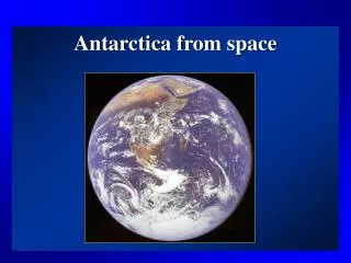
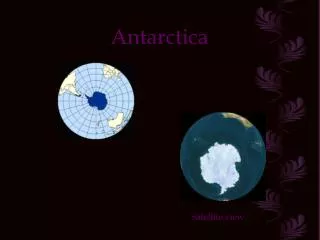
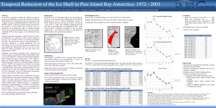
Temporal Reduction of the Ice Shelf in Pine Island Bay Antarctica: 1972 - 2003 Ya’ ShontiBridgers(ECSU), Jessica Brownlow (MVSU), Kirsten Hawk (Spelman), Mentor: Dr. Malcolm LeCompte Principal Investigator: Dr. Linda B. Hayden, 1704 Weeksville Rd, Box 672, Elizabeth City, North Carolina 27909 Determining the Area Once the new co-registered image was created, the GL was overlain upon it Multiple, individual iterations of the area were made, and an average was taken A standard deviation formula was used to establish the data’s variability Abstract In an effort to determine whether the Antarctic ice sheet is growing or diminishing over long time intervals, Dr. Robert Bindschadler led an international team of glaciologists and computer scientists, including Elizabeth City State University (ECSU) students, to obtain an accurate measure of the area of the Antarctic ice sheet. Before the ice sheet’s area was determined, the grounding line (GL), or boundary dividing the ice sheet resting on land from floating ice, was located by combining 2003 Landsat imagery and satellite-based laser altimetry. Landsat image data contemporary with that used to create the grounding line was compared to earlier Landsat imagery of the same area. A small ice shelf—now known as the ECSU Ice Shelf—near the eastern entrance to Pine Island Bay was previously identified as having diminished over an approximate 31-year span and the progressive reduction of its area qualitatively characterized. Here, the area loss of the ECSU Ice Shelf is quantified over time from 1972 to its disappearance in 2003. Departures from perfect geographic pixel registration in Landsat imagery of the ECSU Ice Shelf collected before 2003 was corrected with ITT’s Visualization Information Solutions’ ENVI image processing software using a 2003 Landsat 7 Enhanced Thematic Mapper (ETM) image as a reference. Older images from Landsat 4,5 Thematic Mapper (TM) and Landsat 7 (ETM) were registered to conform to the common fixed geographic control points visible on both images. By overlaying the GL on the registered (warped) images, the area changes in the ice shelf were computed. An average ice shelf area was determined from four independent measurement trials for each of the pre-2003 Landsat image. Landsat Images from 2003 used in creating the GL were obtained from the United States Geological Survey (USGS) archive. The older, cloud free Landsat 4, 5 TM and 7 ETM images of the Pine Island Glacier region were obtained from another USGS archive. Results provided: 1. A quantitative description of the disappearance of the ECSU Ice Shelf from 1972 through 2003; 2. Validation of the grounding line’s actual location; 3. A survey of Antarctic coastal features that may have experienced climate related change. Keywords-ENVI; GLAS, ground control points, grounding line; Landsat 7 ETM+; ECSU Ice Shelf Background Research by the U.S. Geological Survey has documented the retreat of every ice front in the southern part of the Antarctic Peninsula from 1947 to 2009. In subsequent research, an ECSU student team discovered that an ice shelf—now known as the ECSU Ice Shelf—had completely disappeared by the time that the grounding line was established in 2003. Prior work provided a qualitative description of the ice shelf’s disappearance. The actual area reduction of the ECSU Ice Shelf remained to be quantitatively evaluated. Conclusion Shelf area decreased from 1972 to ≈ 1981Shelf Area increased 1981 to ≈ 1986Shelf Area declined until it disappeared ≈ 2003Subsequent Landsat images shows no ice shelf return 2. Grounding Line Location was validated 3. Sea Ice cover is episodic Figure 1. Antarctic continent showing study areas of USGS study area, in black outline and ECSU research within red circle encompassing Pine Island Bay [1]. Figure 1. LANDSAT 5 image of the ice shelf in1986 Figure 2. 1986 LANDSAT 5 image with the ice shelf area now shown in red Figure 3. LANDSAT 7 image showing the current situation from 2003 through 2011, where the ice shelf has disappeared Methodology Through the use of ENVI software, Landsat images obtained from USGS archives were geo-registered to receive an accurate measure of the ECSU Ice Shelf’s area. Downloaded images from the years: 1972, 1981, 1986, 1989, 1991, 1997, 2000, 2001, and 2003. Images did not have the same pixel to coordinate registration as the older Landsat archived imagery. Results First trial – no specified limiting geographic points Second trial – two specified limiting geographic points: one lying to the SE of the ice shelf at 73°57’25’’ S, 102°16’00’’ W and one lying NW of the ice shelf at 73°55’55’’ S, 102°27’50’’ W. • Future Work • Investigate the remaining Pine Island Bay coastline and Larson Ice Shelf region • Continue grounding line validation and survey of Antarctic coastline • Examine using new NASA Goddard software • Examine as many data sets as possible • Incorporate other satellite image data sources: • SPOT-image: Better spatial resolution than Landsat • IKONOS: Better spatial resolution than Landsat • AQUA & TERRA (MODIS): Lower spatial resolution than Landsat Table 1. Average of four trials with unspecified limiting geographic points Image-to-Image Registration 2003 Landsat 7 images were used as reference images Five common geographic points in each image were selected as ground control points to which the new images could be warped or co-registered Table 2. Average of four trials with specified limiting geographic points Reference [1] R. Bindschadler, H. Choi, A. Wichlacz, R. Bingham, J. Bohlander, Kelly Brunt, et al, “Getting around antartica: new high-resolution mappings of the grounded and freely-floating boundaries of the Antarcic ice sheet created for the International Polar Year,” in press [2] “Ice shelves disappearing on Antarctic Peninsula,” February 2010, http://www.usgs.gov/newsroom/article.asp?ID=2409. [3] G. Casassa, W. Krabill, P. Gogineni, E. Rignot, A. Rivera, and R. Thomas, “Accelerated ice discharge from the Antarctic Peninsula following the Collapse of Larsen B ice shelf,” Geophysical Research letters, Vol. 31, L18401, doi: 10.1029/2004GL020697, 2004. [4] “About USGS,” http://www.usgs.gov/aboutusgs/. [5] “Global Visualization (Glovis) viewer,” October 2005, http://pubs.er.usgs.gov/djvu/FS/2005_3118.pdf. [6] “The Landsat Program,” http://landsat.gsfc.nasa.gov/. [7] “Landsat Image Mosaic of Antarctica,” http://lima.usgs.gov.