Download
1 / 21
210 likes | 511 Vues
Using the New ArcGIS Runtime SDK for Microsoft .NET Framework for Homeland Security: A Bomb Threat Analysis Example. Jo Fraley jfraley@esri.com. Bomb Threat Analysis Example. Agenda. Bomb Threat Stand-Off Distances Bomb Threat Example Application What it took to build

E N D
Using the New ArcGIS Runtime SDK for Microsoft .NET Framework for Homeland Security: A Bomb Threat Analysis Example Jo Fraley jfraley@esri.com
Bomb Threat Analysis Example Agenda • Bomb Threat Stand-Off Distances • Bomb Threat Example Application • What it took to build • ArcGIS Runtime SDK for .NET • Options for applications • Creating packages • Functionality • Deploying applications Using the New ArcGIS Runtime SDK for Microsoft .NET Framework for Homeland Security: A Bomb Threat Analysis Example
Bomb Threat Analysis Example Demo Using the New ArcGIS Runtime SDK for Microsoft .NET Framework for Homeland Security: A Bomb Threat Analysis Example
ArcGIS Runtime SDK for .NET Using the New ArcGIS Runtime SDK for Microsoft .NET Framework for Homeland Security: A Bomb Threat Analysis Example
ArcGIS Runtime • Runtime built using C++ • Exploits the capabilities of the device • Functionality exposed to developers via an API native to the platform • Intuitive to learn • Common functionality set and conceptual model • Eases multi platform development Using the New ArcGIS Runtime SDK for Microsoft .NET Framework for Homeland Security: A Bomb Threat Analysis Example
Device Platforms Phone Tablet Desktop Embedded Using the New ArcGIS Runtime SDK for Microsoft .NET Framework for Homeland Security: A Bomb Threat Analysis Example
Runtime Platforms Desktop OS X Desktop Client Windows Store QT .NET iOS JavaSE Mobile Android Embedded Windows Mobile Windows Phone Using the New ArcGIS Runtime SDK for Microsoft .NET Framework for Homeland Security: A Bomb Threat Analysis Example
Windows Desktop API • Build native apps for the Windows Desktop platform • Windows Presentation Foundation (WPF) • .NET 4.5 • 64-bit and 32-bit • Task-based Async Pattern • Designed for MVVM • Codebase shared with APIs for Store apps and Phone • Full capabilities of the ArcGIS Runtime • Plus LocalServer for advanced Geoprocessing Using the New ArcGIS Runtime SDK for Microsoft .NET Framework for Homeland Security: A Bomb Threat Analysis Example
Functionality Overview • Build a map • Edit • Search/Query • Geocoding and Routing • Perform analysis Using the New ArcGIS Runtime SDK for Microsoft .NET Framework for Homeland Security: A Bomb Threat Analysis Example
Options for applications • Online connected • Offline disconnected • All local services • All external services • Combination of both Using the New ArcGIS Runtime SDK for Microsoft .NET Framework for Homeland Security: A Bomb Threat Analysis Example
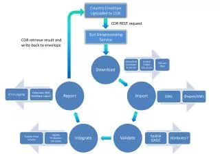
Local Data Sources • Map package: MPK • Tile package: TPK • Geoprocessing package: GPK • Locator package: GCPK Using the New ArcGIS Runtime SDK for Microsoft .NET Framework for Homeland Security: A Bomb Threat Analysis Example
Packages for local services Using the New ArcGIS Runtime SDK for Microsoft .NET Framework for Homeland Security: A Bomb Threat Analysis Example
Packages for local services Using the New ArcGIS Runtime SDK for Microsoft .NET Framework for Homeland Security: A Bomb Threat Analysis Example
Creating a local service LocalMapServiceschoolsAndhospitals = new LocalMapService(apppath + "\\MapFeatures.mpk"); await schoolsAndhospitals.StartAsync(); ArcGISDynamicMapServiceLayerarcGISDynamicMapServiceLayer = new ArcGISDynamicMapServiceLayer() { ID = "schoolsAndhospitals", ServiceUri = schoolsAndhospitals.UrlMapService, }; arcGISDynamicMapServiceLayer.IsVisible = false; mapView.Map.Layers.Add(arcGISDynamicMapServiceLayer); Using the New ArcGIS Runtime SDK for Microsoft .NET Framework for Homeland Security: A Bomb Threat Analysis Example
Using the Geometry Engine • Create geometries from existing geometries by performing operations • Buffer, Clip, Densify, Difference, Offset, Union, Intersection, Symmetric Difference, and Simplify • Basic relationsips • Contains, Crosses, Disjoint, Intersects, Overlaps, Touches, Within, and Equals • Project to different spatial references varbufferInside = GeometryEngine.Buffer(geom, BuildingEvacDistance); Using the New ArcGIS Runtime SDK for Microsoft .NET Framework for Homeland Security: A Bomb Threat Analysis Example
Using the QueryTask ArcGISDynamicMapServiceLayerlocalLayer = mapView.Map.Layers["schoolsAndhospitals"] as ArcGISDynamicMapServiceLayer; varqueryTask = new QueryTask(new Uri(localLayer.ServiceUri + "/0")); var query = new Query("1=1") { ReturnGeometry = true, OutSpatialReference = mapView.SpatialReference, Geometry = outsideBuffer, }; query.OutFields.AddRange(new string[] { "NAME" }); graphicSchool.Renderer = new SimpleRenderer() { Symbol = new SimpleMarkerSymbol() { Color = Color.FromRgb(255, 0, 0), Size = 8 } }; varqueryResult = await queryTask.ExecuteAsync(query); if (queryResult != null && queryResult.FeatureSet != null) { graphicSchool.Graphics.AddRange(queryResult.FeatureSet.Features); } Using the New ArcGIS Runtime SDK for Microsoft .NET Framework for Homeland Security: A Bomb Threat Analysis Example
Using a SceneView <esri:SceneView x:Name="sceneView" Visibility="Hidden"> <esri:Scene x:Name="map" > <esri:ElevationLayerServiceUri="http://services.arcgisonline.com/arcgis/rest/directories/cache_globe/GlobeCache/USGS_Elevation_US_20070531"/> <esri:ArcGISTiledMapServiceLayer x:Name="myService" ServiceUri="http://server.arcgisonline.com/ArcGIS/rest/services/ESRI_Imagery_World_2D/MapServer" /> <esri:SceneLayer x:Name="myscenelayer" ServiceUri="http://burlo.esri.com/arcgis/rest/services/Hosted/sfo/SceneServer/Layers/0"/> <esri:GraphicsLayer x:Name="myPointandText"/> </esri:Scene> </esri:SceneView> Using the New ArcGIS Runtime SDK for Microsoft .NET Framework for Homeland Security: A Bomb Threat Analysis Example
Drawing Threat Dome SphereSymbol sphere = new SphereSymbol(); sphere.Color = Color.FromArgb(155, 255, 0, 0); sphere.LatLOD = 10; sphere.LonLOD = 10; sphere.Radius = (float)OutdoorEvacDistance; //in meters sphere.SpherePosition = RuntimeCoreNet.SpherePosition.Center; Graphic graphic = new Graphic { Geometry = e.Location, Symbol = sphere }; Using the New ArcGIS Runtime SDK for Microsoft .NET Framework for Homeland Security: A Bomb Threat Analysis Example
Sessions on the ArcGIS Runtime SDK for Microsoft .NET Framework • Developing Mobile Apps with ArcGIS Runtime SDK for Microsoft .NET Framework • Thursday, July 17, 2014, 10:15 am – 11:30 am • Location: Room 5A Using the New ArcGIS Runtime SDK for Microsoft .NET Framework for Homeland Security: A Bomb Threat Analysis Example
Thank you… Please fill out the session survey: Using the New ArcGIS Runtime SDK for Microsoft .NET Framework for Homeland Security: A Bomb Threat Analysis Example Paper – pick up and put in drop box Using the New ArcGIS Runtime SDK for Microsoft .NET Framework for Homeland Security: A Bomb Threat Analysis Example
Using the New ArcGIS Runtime SDK for Microsoft .NET Framework for Homeland Security: A Bomb Threat Analysis Example